Tuesday, November 18, 2014

Fun stuff on the way!


Ok, get your hall passes ready because you might just miss this next swell if you blink!  Wednesday is going to be small…very small but by the end of the day we should start to see signs of life out of the WNW from a system that’s dropping in on us for a quick visit.  Thursday morning we should see a significant pick up in wave height with HH surf at most beaches around SD, slightly smaller in OC and LA but much improved from the past few days.  Fairly consistent with HH and some OH sets through the day as the swell peaks midday and starts to drop off fairly quickly in the evening.  Friday looks like chest high waves to start the day and a second WNW pulse in the waist/chest range to close out the work week.  There’s a decent amount of W so the west facing beaches will see some closeouts.

Saturday looks smaller with waist high surf or smaller around So Cal.  Sunday another but smaller WNW moves in and delivers some waist/chest high wind-type swell.  This swell hangs out through Monday with some slightly bigger waves Monday morning.  Tuesday we’ll see a new NW groundswell fill in but the energy looks like it’s aimed a bit more south of us so we’ll only really see waist/chest high surf throughout the day.  Not a lot of big swell makers looming out there right now.  Might get kind of quiet for the rest of the Thanksgiving holiday week and into the weekend.  Stay tuned and I’ll let you know if there’s anything juicy coming up!

Weather is definitely moving towards winter as we have cooler daytime air temps in the high 60s and nighttime temps dropping into the high 40s and low 50s.  Ouch…that makes for a brisk dawn patrol!  Morning and evening marine layer make way for sunshine midday for Wed. Thursday we’ll see more clouds and chances of showers for Thursday night and thru Friday.  Luckily this “storm” won’t bring much in terms of wind so fairly glassy calm days as those swells show up.  Things warm up a bit for the middle of the Thanksgiving week but we’ll still see those chilly nighttime temps.  Water temps have dipped a degree or two and are in the high to mid-60s.  We may see a little dip as that WNW stirs up the cooler water.  We’re starting to see those early morning high tides slow things down again and the negative lows draining out in the late afternoon.  

Looks like some fun surf with pretty nice conditions (minus the 30% chance of showers Friday).  Check the tides and pick your sessions accordingly if you can!  I’m calling the Thursday mid/late morning session to be pretty fun!

Stay wet So Cal!
Mish


Ida at her Secret Spot  5 years ago…Nov. 19, 2009

Tides for La Jolla (Scripps Institution Wharf) starting with November 18, 2014.

www.saltwatertides.com
Day        High      Tide  Height   Sunrise    Moon  Time      % Moon
           /Low      Time    Feet    Sunset                    Visible
 
Tu  18     High   6:12 AM     5.2   6:22 AM    Rise  2:37 AM      21
    18      Low  12:44 PM     0.8   4:46 PM     Set  2:32 PM
    18     High   6:44 PM     4.0
 
W   19      Low  12:13 AM     1.4   6:23 AM    Rise  3:33 AM      14
    19     High   6:40 AM     5.5   4:46 PM     Set  3:08 PM
    19      Low   1:18 PM     0.3
    19     High   7:25 PM     4.0
 
Th  20      Low  12:45 AM     1.5   6:24 AM    Rise  4:30 AM      7
    20     High   7:09 AM     5.8   4:45 PM     Set  3:47 PM
    20      Low   1:53 PM    -0.2
    20     High   8:05 PM     4.1
 
F   21      Low   1:18 AM     1.5   6:25 AM    Rise  5:29 AM      3
    21     High   7:39 AM     6.1   4:45 PM     Set  4:30 PM
    21      Low   2:29 PM    -0.6
    21     High   8:46 PM     4.1
 
Sa  22      Low   1:51 AM     1.6   6:26 AM    Rise  6:29 AM      0
    22     High   8:11 AM     6.3   4:45 PM     Set  5:17 PM
    22      Low   3:07 PM    -0.8
    22     High   9:28 PM     4.0

Saturday, November 15, 2014

Get on it!

Quick update...swell's actually on the rise and it's offshore early.  Tide's is on it's way out for the dawn patrol.  Should be fun and more sizable that originally forecasted.  

See ya at the beach!

Stay wet SoCal!

Mish

Tuesday, November 11, 2014

Small WNW heading our way...


Aloha!  We’re seeing the tail end of a smaller NW swell in the water.  The good news is that there’s a macking swell hitting Hawaii and the season opener for Pipeline, Waimea and Jaws.  The not-so-good news is that the bulk of the energy is going to miss So Cal as it’s aimed more south of us.   Wednesday will see smaller surf in the knee to waist high range with a hint of left over south swell at the better summer spots.  Thursday we should see a bump up in size as the energy from that WNW groundswell shows up with some waist/chest sets by evening.  Friday will see the majority of the swell.  I’m really not expecting much from this…waist/chest with a few stand out shoulder high sets at the best winter breaks later in the day Friday.  Saturday and Sunday the swell backs off and we’ll see waist high surf throughout the weekend.  Size dips Monday and then a bit of windswell kicks in late Monday and thru Tuesday as a little low pressure system moves into town.  We could see some showers from that but if there’s waves we’ll take it!   Things get a bit quiet in both hemispheres for awhile.  The northern hemi has a few small fairly gutless storms moving across the latitudes but I’m not seeing anything significant develop out of them.  Patience.

Weather wise we are definitely moving into late Fall and Winter.  We have cooler air temps in the high 60s for daytime (I love that we call that Fall/Winter temps!) and mid50s at night.  Chances of drizzle tonight, Wed and Thurs night/Fri.  The best chance for showers is actually next Tues and into Wed.  We’ll have a slight warming trend for the weekend before it cools down a little again.  Boy I hope we get some showers because we NEED THAT WATER!  Winds remain light with some light SW winds tomorrow and otherwise calm in the evenings and out of the N/NW by midday.  Looks like we’ll see mostly clouds until the weekend when we’ll see a bit more sunshine.  Tides are fairly flat during the day this week.  Water temps still in the high 60s though so that’s a bonus!

Make the most out of what WNW we get and enjoy the weather!  You could be stuck in Michigan’s deep freeze!

Stay wet So Cal!
Mish


Jeannette Prince sliding on a sunny day at Swamis.


Tides for La Jolla (Scripps Institution Wharf) starting with November 12, 2014.

www.saltwatertides.com
Day        High      Tide  Height   Sunrise    Moon  Time      % Moon
           /Low      Time    Feet    Sunset                    Visible
 
W   12     High   1:41 AM     3.6   6:17 AM     Set 11:07 AM      75
    12      Low   6:06 AM     3.0   4:50 PM    Rise 10:11 PM
    12     High  12:01 PM     4.4
    12      Low   7:31 PM     0.8
 
Th  13     High   3:03 AM     3.7   6:18 AM     Set 11:45 AM      66
    13      Low   7:41 AM     3.1   4:49 PM    Rise 11:04 PM
    13     High   1:12 PM     4.0
    13      Low   8:34 PM     1.1
 
F   14     High   4:06 AM     3.9   6:19 AM     Set 12:20 PM      57
    14      Low   9:26 AM     2.9   4:48 PM    Rise 11:57 PM
    14     High   2:39 PM     3.7
    14      Low   9:33 PM     1.2
 
Sa  15     High   4:47 AM     4.2   6:20 AM     Set 12:53 PM      48
    15      Low  10:41 AM     2.4   4:48 PM
    15     High   4:01 PM     3.6
    15      Low  10:23 PM     1.3
 
Su  16     High   5:18 AM     4.5   6:21 AM    Rise 12:50 AM      38
    16      Low  11:31 AM     1.9   4:47 PM     Set  1:26 PM
    16     High   5:07 PM     3.7
    16      Low  11:04 PM     1.3

Thursday, November 6, 2014

Where'd the swell go? Give it time...


Howdy!  Santa Anas, 80 degree daytime temps and 69 degree water…what more could you want? Oh, right…waves.  Well, the prognosis for the immediate future is not ideal but the long term forecast is looking up.  For the next week we’re looking at new SW swell for Friday in the waist high range at the better summer spots (Yes, I know it’s November!).  Then some NW windswell makes it way into town for Sat and Sun with swell in the knee/waist high range in SD but smaller in OC and LA.  Late Sun and thru Mon we’ll see knee high waves.  Tuesday things pick up a bit with some new NW groundswell.  This isn’t all that big with waves in the waist high with chest high sets for the day. For Wed I’ve seen mixed models. Some say not much swell for Wed/Thursday but others say we’ll see the start of some nice WNW groundswell.  The focus is more on the Hawaiian Island and the Baja Peninsula but SD should see some fun waves pick up from that Aleutian system.  I’ll call it at chest/head high for late Wed and into Thursday.  Things back down Friday and quiet down for a bit.  No monster swells on the way as far as I can tell.  Northern hemi is looking more active as the southern hemi starts to quiet down as they roll into summer.

I guess the good news is that at least the weather is going to be sunny and nice.  The Santa Anas will start to break down through the weekend with air temps in the mid-70s for most of the weekend and low 70s to start the week. Much cooler sleeping temps in the mid to low 50s with clear skies and plenty of moonshine at night and sunshine during the day.  A bit more marine layer moves in Sunday night and into Monday but burns off for sunshine by midday.  Winds are offshore for the dawn patrols and switch to SW/W winds by late morning and remain a little breezy for the afternoon before the evening glassoff.  Water temps in the high 60s still for most of So Cal.  Tides are swinging big time right now as we have a GORGEOUS full moon tonight.  My favorite moon is the November Dawn Patrol moonset over the water.  Huge morning high tides slowing the tiny swell way down and drained out late afternoon lows making for great tidepool conditions especially for the wee ones!  Not a drop of rain in site!  For the latest update on the El Nino (or lack thereof) from NOAA check out:


Not a lot of macking surf in the future but some ripples to keep you in the water for when the big stuff hits!

Stay wet So Cal!
Mish

In case you missed the Green Flash sunsets lately...
here's one for you from October 24th in Cardiff.


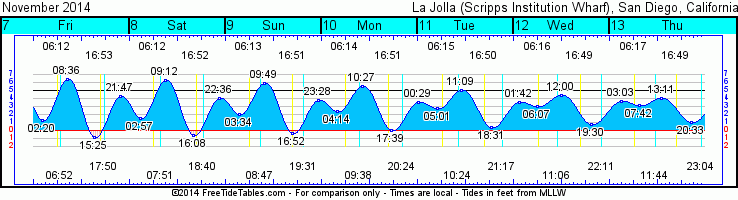
Tides for La Jolla (Scripps Institution Wharf) starting with November 7, 2014.

www.saltwatertides.com
Day        High      Tide  Height   Sunrise    Moon  Time      % Moon
           /Low      Time    Feet    Sunset                    Visible
 
F    7      Low   2:20 AM     1.3   6:12 AM     Set  6:52 AM      99
     7     High   8:36 AM     6.4   4:53 PM    Rise  5:50 PM
     7      Low   3:25 PM    -0.9
     7     High   9:48 PM     4.3
 
Sa   8      Low   2:57 AM     1.6   6:13 AM     Set  7:52 AM      98
     8     High   9:12 AM     6.3   4:52 PM    Rise  6:40 PM
     8      Low   4:07 PM    -0.7
     8     High  10:36 PM     4.0
 
Su   9      Low   3:34 AM     2.0   6:14 AM     Set  8:48 AM      95
     9     High   9:49 AM     5.9   4:52 PM    Rise  7:31 PM
     9      Low   4:51 PM    -0.4
     9     High  11:28 PM     3.8
 
M   10      Low   4:14 AM     2.4   6:15 AM     Set  9:39 AM      90
    10     High  10:27 AM     5.4   4:51 PM    Rise  8:24 PM
    10      Low   5:39 PM     0.0
 
Tu  11     High  12:28 AM     3.6   6:16 AM     Set 10:25 AM      83
    11      Low   5:01 AM     2.7   4:50 PM    Rise  9:17 PM
    11     High  11:09 AM     5.0
    11      Low   6:31 PM     0.5

Sunday, October 26, 2014

Bit of WNW leftover, S and W on the way...


Oh boy!  More good surf this past weekend!  Hope you all got a slice of the action!  There were plenty of WNW waves and plenty of people out there to surf ‘em!  Looks like Monday morning will see the tail end of that swell with some fun HH/OH sets in SD and chest/shoulder for OC and LA.  Size tapers off quickly through the day with the sunset sessions seeing waist/chest with the occasional shoulder high set.  Tuesday drops even a bit more with waist/chest high out of the WNW and a new steep S filling in for OC and LA.  San Diego won’t really be seeing much of that as it flies right by.  Wed looks smaller in SD with the very end of the WNW and some new short period groundswell in the second half of the day. OC and LA will continue to see smaller S.  Things bump up a hair Thursday with that smaller WNW and surf in the waist high range and chest high sets at the better winter spots.  A bit less of that old S for OC/LA as the angle moves easterly from their swell window but a small SW helping to bump up the waves a little.  Halloween Friday stays about the same for both with waist/chest high waves. Saturday there’s a W windswell swell starting to make it’s move and it fills in a bit more late Sat with chest high waves and into Sunday.  Waves bump up Sunday to chest/shoulder high and bit of winds getting on it as a low pressure system moves into town.  Slightly smaller in OC and LA with some island blockage but you’ll still get the weather!

Weather wise we’re definitely moving into Fall/Winter mode as the full suits are out for the dawn patrols and we’re starting to see some beautiful sunsets.  Morning temps are cool and in the low 60s and highs are only making it to the low 70s but we’re still seeing some nice sunshine.  We’ll see sunnier skies by Wed with a little warming and then the morning and evening fog rolls in for the end of the week.  Things cool down a bit for the weekend as a low pressure system moves south for the first time in awhile.  Highs in the high 60s and slightly cooler nights.  To kick off the week the winds look to be light offshore in the mornings and turn westerly in the afternoon. By the end of the week as that system moves south the winds will also become more southerly and even a slight chance of showers for Trick or Treat night and half of the way through Saturday. Water temps are still pretty darn nice for October with low 70s all along the SD coast and high 60s in the LA area.  Tides are swingin’ something nasty with big highs midday and drained out negative lows by sunset.  Looks like the AM sessions will be fun!

Can’t beat these October sessions with overhead waves and water!

Have fun and stay wet!
Mish

Sunday morning session


Sunday sunset


Tides for La Jolla (Scripps Institution Wharf) starting with October 26, 2014.

www.saltwatertides.com
Day        High      Tide  Height   Sunrise    Moon  Time      % Moon
           /Low      Time    Feet    Sunset                    Visible
 
Su  26      Low   4:18 AM     1.8   7:02 AM    Rise  9:39 AM      4
    26     High  10:39 AM     5.8   6:04 PM     Set  8:25 PM
    26      Low   5:41 PM    -0.1
 
M   27     High  12:06 AM     3.8   7:03 AM    Rise 10:36 AM      9
    27      Low   4:53 AM     2.2   6:03 PM     Set  9:19 PM
    27     High  11:17 AM     5.6
    27      Low   6:33 PM     0.1
 
Tu  28     High   1:09 AM     3.6   7:04 AM    Rise 11:31 AM      16
    28      Low   5:36 AM     2.5   6:02 PM     Set 10:17 PM
    28     High  12:04 PM     5.3
    28      Low   7:34 PM     0.3
 
W   29     High   2:27 AM     3.5   7:05 AM    Rise 12:23 PM      25
    29      Low   6:44 AM     2.9   6:01 PM     Set 11:19 PM
    29     High   1:08 PM     5.0
    29      Low   8:45 PM     0.4
 
Th  30     High   3:53 AM     3.7   7:05 AM    Rise  1:11 PM      35
    30      Low   8:33 AM     3.0   6:00 PM
    30     High   2:36 PM     4.6
    30      Low   9:58 PM     0.5

Monday, October 13, 2014

Lingering NW and then a little SW


Well, how about them apples?  That was a nice "little" NW swell!  It was a little bigger than I expected...that most people expected I think!  Hope you all got a few waves today and this weekend.  I saw some nice sharing going on and plenty of carnage at some of the more crowded breaks.  We’re coming off the NW on Tuesday but should still see some fun waist/chest high waves through the day.  There’s a background SW swell that the summer spots should get some smaller surf from…waist high with some NW mixed in.  Size backs down further on Wednesday to mostly waist high with some more background SW.  The SW becomes a little more dominant on Thurs and Fri with waves in the waist/chest range at the better summer spots with the winter breaks picking up some shorter period NW.  Saturday we’re looking at slightly smaller surf to kick off the weekend with small WNW swell in the knee/waist high range.  There should still be some lingering S in there but nothing to write home about.  Sunday another small NW looks to fill in.  Size picks up a little but there’s not a lot of juice in this one.  Waist/chest high waves at most of SD with OC and LA getting blocked by the island and just not picking up much of the swell.  There are a few nugget storms brewing in both hemispheres but nothing that I would call worth making notes of just yet.

We’re definitely seeing some fall weather these days with cooler daytime temps and definitely cooler nighttime temps.  Look for highs in the low 70s and nighttime lows in the high 50s all week.  More patchy fog and even a chance of drizzle late Tuesday night and into Wed as a little front flies thru. Slightly warmer in OC/LA but also chances of drizzles.  Pretty much the same into the weekend…70s daytime and high 50s nighttime with partial sunshine midday. We’ll see a bit of SW winds for Tuesday and W wind through the evening into Wed.  After that winds look fairly typical with calm overnight and onshore westerly winds picking up late morning and into the afternoon before calming down for the sunset session.  Tides aren’t moving much through the day as we come off that awesome Blood Moon last week.  Medium high mid-morning moves inches down to a medium low mid-afternoon. 

Get on the last bit of that NW and have fun!  Things will quiet down for awhile.

And stay wet San Diego!
Mish


Lines at sunset at a little spot I know of...

Tides for La Jolla (Scripps Institution Wharf) starting with October 14, 2014.

www.saltwatertides.com
Day        High      Tide  Height   Sunrise    Moon  Time      % Moon
           /Low      Time    Feet    Sunset                    Visible
 
Tu  14     High   3:28 AM     3.4   6:53 AM     Set 12:48 PM      68
    14      Low   7:46 AM     3.1   6:17 PM    Rise 11:35 PM
    14     High   1:56 PM     4.5
    14      Low   9:35 PM     1.0
 
W   15     High   5:15 AM     3.6   6:53 AM     Set  1:31 PM      59
    15      Low   9:36 AM     3.2   6:16 PM
    15     High   3:23 PM     4.1
    15      Low  10:51 PM     1.1
 
Th  16     High   6:13 AM     3.9   6:54 AM    Rise 12:28 AM      49
    16      Low  11:15 AM     2.9   6:15 PM     Set  2:10 PM
    16     High   4:49 PM     4.1
    16      Low  11:48 PM     1.0
 
F   17     High   6:46 AM     4.2   6:55 AM    Rise  1:21 AM      40
    17      Low  12:16 PM     2.4   6:14 PM     Set  2:47 PM
    17     High   5:56 PM     4.2
 
Sa  18      Low  12:30 AM     1.0   6:56 AM    Rise  2:13 AM      31
    18     High   7:11 AM     4.5   6:12 PM     Set  3:21 PM
    18      Low  12:57 PM     1.9
    18     High   6:46 PM     4.4

Tuesday, October 7, 2014

Smaller but still fun and warm!


Oh boy!  This whole endless summer thing is nice but I think we’re all ready for some winter swell!  Hurricane Simon sent some steep S passing most of SD and hitting OC/LA but we had some pretty fun surf over the past weekend.  We’re seeing the rail end of it for Wed morning and it drops off significantly from waist/chest at the better summer spots to knee high later in the day.  The good news is that the southern hemi is throwing a little something our way so surf will hit the waist/chest high range again by Thursday morning.  This next SW has much better angle than the previous swell so more of So Cal will see it.  Swell peaks Thursday and we’ll probably see a hint of NW windswell as well.  Friday things back down a little with waist high waves around most of town and slightly bigger sets at the summer spots.  Saturday the SW drops off and a NW groundswell delivers some surf to the winter breaks for the second half of the day. 

Sunday we’ll actually see some small SW. It’s not really aimed our direction and the energy level isn’t so hot so we’re looking at maybe some waist high waves out of that. Monday another NW ground swell makes it way into town. Winter breaks will see more swell in the waist/chest range.  It’s nothing huge but there’s plenty more activity in the Northern Hemi and it’s still early! Size holds for Tuesday and becomes more westerly. That means a little more closed out at the west facing beaches but still plenty of fun.  Looks like the southern hemi is squeaking out another ground swell but it’s a solid 10 days away so it’s no “gimme”.  The northern hemi, as I mentioned, is starting to crank up and will hopefully start firing some doozies at us. I think we’re due for a good winter of surf. Something tells me…it’s just a gut feeling.

Weather is hot and sticky! Holy hurricane weather Batman!  Post-tropical depression Simon is taking a turn east at least but like Hurricane Odile is dragging some of that heat and humidity up with him.  I think the worst heat is past us now (I hope) and we’ll see a slight cooling trend through the weekend.  Then things heat up yet again for the start of next week.  Wind patterns look pretty typical with calm and slightly offshore winds overnight and westerly mild to moderate breeze in the afternoon.  Water temps are back up after that nice boost of S swell.  We’re looking at low 70s along most of the SD and OC coast and slightly cooler in LA and down south of Pt. Loma.  Tides are swinging big time with tonight’s huge full moon.  Pretty spectacular stuff if you can stay awake long enough to watch the full lunar eclipse Wed at 3am PST.  Huge full mid-morning tides with negative lows late afternoon.  Lots of water movement all day so watch those tides as they’’ll make a big difference in your session.

Looks like more fun but not huge surf!

Stay wet So Cal!
Mish


A preview of winter surf - unknown surfer at Secret Spot
(Jan. 2010)

Tides for La Jolla (Scripps Institution Wharf) starting with October 8, 2014.

www.saltwatertides.com
Day        High      Tide  Height   Sunrise    Moon  Time      % Moon
           /Low      Time    Feet    Sunset                    Visible
 
W    8      Low   3:12 AM     0.2   6:48 AM     Set  6:59 AM      99
     8     High   9:28 AM     6.3   6:25 PM    Rise  6:45 PM
     8      Low   3:50 PM    -0.5
     8     High  10:05 PM     5.2
 
Th   9      Low   3:49 AM     0.6   6:49 AM     Set  8:04 AM      99
     9     High  10:04 AM     6.3   6:23 PM    Rise  7:28 PM
     9      Low   4:35 PM    -0.5
     9     High  10:53 PM     4.9
 
F   10      Low   4:25 AM     1.1   6:50 AM     Set  9:08 AM      97
    10     High  10:41 AM     6.2   6:22 PM    Rise  8:14 PM
    10      Low   5:22 PM    -0.3
    10     High  11:43 PM     4.4
 
Sa  11      Low   5:03 AM     1.6   6:51 AM     Set 10:10 AM      92
    11     High  11:20 AM     5.9   6:21 PM    Rise  9:02 PM
    11      Low   6:12 PM     0.0
 
Su  12     High  12:40 AM     4.0   6:51 AM     Set 11:07 AM      85
    12      Low   5:43 AM     2.1   6:20 PM    Rise  9:52 PM
    12     High  12:01 PM     5.4
    12      Low   7:09 PM     0.4