Showing posts with label Oz. Show all posts

Monday, August 26, 2013

Small SW swell coming!

Yes, it’s Monday!  So the way the models are shaping up right now it looks like we should see some SW swell making it’s way to shore by late Wed and things should pick up into the waist high range for Thursday with Friday seeing the peak of the swell and the occasional chest high set.  That swell should start to taper but then we’ll see some activity from a tropical storm that forming down off Mainland Mex. Looks like it’ll be a steep S but hopefully there’s enough energy that we will get some waist high waves from it through most of the Labor Day weekend (Saturday and Sunday).  Monday it looks like we’ll be interrupted by more NW windswell but surf will stay in generally the same range…waist high.

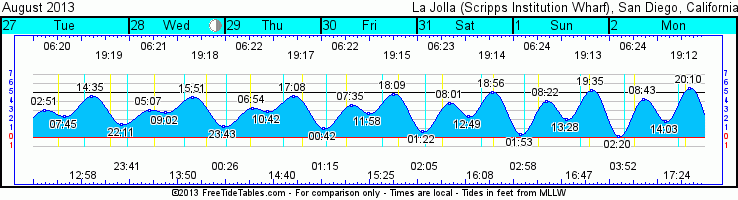
As far as this subtropical moisture is concerned get used to it.  Looks like it’ll be sticking around for the upcoming week.  Expect temps in the mid to upper 70s thru the weekend and high humidity.  As chances of coastal thunderstorms taper off tonight expect mostly sunny skies through Friday.  Clouds build Friday night but clear by mid-morning on both Sat and Sun with clear skies expected for Labor Day.  Expect pretty mild winds all week as well.  We’ll see glassy morning sliding conditions with some mild WNW winds by midday thru the holiday weekend.  Tides aren’t doing much as we are coming off that full blue moon last week.  Medium low I the morning heads to a medium high in the early afternoon before going back out after sunset.  Less and less difference in tides as we end the week.  Water temps have chilled down a little again too…mid to low 60s are our temps these days.  UGH!

Well, at least we’ll see a little swell!
Stay wet San Diego!
Mish

Ocean Notes:

Gotta love a place called "Cow Bombies"!!!!  The Mavs of Oz!  Thanks Surfline!  
Tonight's Sunset in Cardiff by the Sea, CA

Tides for La Jolla (Scripps Institution Wharf) starting with August 26, 2013.

www.saltwatertides.com
Day        High      Tide  Height   Sunrise    Moon  Time      % Moon
           /Low      Time    Feet    Sunset                    Visible
 
M   26     High   1:28 AM     3.7   6:20 AM     Set 12:04 PM      74
    26      Low   6:58 AM     1.9   7:21 PM    Rise 10:58 PM
    26     High   1:36 PM     4.9
    26      Low   8:37 PM     1.5
 
Tu  27     High   2:51 AM     3.1   6:21 AM     Set 12:59 PM      64
    27      Low   7:45 AM     2.4   7:20 PM    Rise 11:41 PM
    27     High   2:35 PM     4.6
    27      Low  10:11 PM     1.5
 
W   28     High   5:07 AM     3.0   6:21 AM     Set  1:51 PM      55
    28      Low   9:02 AM     2.8   7:19 PM
    28     High   3:51 PM     4.5
    28      Low  11:43 PM     1.3
 
Th  29     High   6:54 AM     3.3   6:22 AM    Rise 12:26 AM      45
    29      Low  10:42 AM     2.9   7:17 PM     Set  2:40 PM
    29     High   5:08 PM     4.6
 
F   30      Low  12:42 AM     1.0   6:23 AM    Rise  1:14 AM      36
    30     High   7:35 AM     3.6   7:16 PM     Set  3:26 PM
    30      Low  11:58 AM     2.7
    30     High   6:09 PM     4.8
 

Sunday, February 24, 2013

Fun surf and gorgeous weather!


Greetings SoCal!  We’ve got a nice shorter period W groundswell and mixed up windswell along the coast.  Surf in the shoulder/HH range with some OH sets. We’re looking at the backside of the swell to kick off the week with more shoulder high surf with the occasional HH set at the better winter spots for Monday.  Smaller surf for Tuesday with the tail end of the groundswell in the waist/chest high range throughout the day.  Looks like a new smaller groundswell for Wednesday but really just keeping things in the waist high range with some chest high sets.  The direction will make the southern end of the county see slightly bigger surf.  Pretty much the same deal with Thursday with some early season S swell thrown in there for kicks. The better summer beaches will see signs of that swell. Friday looks like a new NW groundswell. This has a little more angle to it so the better winter spots will definitely see more swell and size.  Look for waist/chest high surf for Thurs and slightly bigger for Friday but not by much…shoulder high sets at the best spots.  We should see a little more SW groundswell at the summer spots so North County is not out of the loop completely.  Waist high southies for the summer spots.  Saturday and the weekend sees a new WNW groundswell that will bump surf into the waist/chest early Saturday and into the chest/shoulder range for Sunday.  Better still we’re in for some sunshine and warm temps for the weekend!

Speaking of weather…we’re due for a warm up over the course of the week.  A nice high pressure ridge is setting up as the Jet Stream takes a hike and we’re expecting sunshine all week and increasingly warmer temps through the week and weekend.  We’re looking at mid60s to kick off the week.  Low70s by Wed.  High 70s Fri and Sat before cooling off a tad for Sun/Mon.  Oh and did I mention mild east winds almost all week.  Yes, a fine week shaping up indeed.  We’re coming up on a Full Moon on Tuesday which means more extreme tides.  Nothing too crazy but the early morning high will definitely slow things down a little as the swell fades.  The negative low tide in the mid-afternoon will drain out some of the beach breaks but there’s a lot of sand on most beaches so I think for the most part most spots should survive the low with a nice little turnaround push for the evening session.  Water temps are in the mid50s still…nothing some rubber can’t cure. 

Fun surf and gorgeous weather coming up this week…enjoy!

Stay wet San Diego!
Mish

Ocean Notes:
1)      Wow, some nice pics coming out of Oz for the Nikon's Australian Surf Photo of the Year contest.  Some big surf down there!

2)    Here’s a fun one…an underwater photographer with a sense of humor!

3)    Mark Healy (badass big wave surfer) deals out his list of the Top 10 most Bad Ass Surfers.

4)    Now THIS is my kind of surf camp!  Where was this when I was a grom?

5)    Here’s a fun 3-minute vid of Mr. Joel Tudor…stylemaster on any board but just so smooth on a log at Cardy.


Tides for La Jolla (Scripps Institution Wharf) starting with February 25, 2013.
www.saltwatertides.com
Day        High      Tide  Height   Sunrise    Moon  Time      % Moon
           /Low      Time    Feet    Sunset                    Visible
 
M   25      Low   2:24 AM     0.8   6:21 AM     Set  5:56 AM      98
    25     High   8:32 AM     5.4   5:43 PM    Rise  5:58 PM
    25      Low   2:57 PM    -0.6
    25     High   9:15 PM     4.7
 
Tu  26      Low   3:00 AM     0.5   6:20 AM     Set  6:31 AM      99
    26     High   9:07 AM     5.3   5:44 PM    Rise  6:58 PM
    26      Low   3:25 PM    -0.4
    26     High   9:43 PM     4.9
 
W   27      Low   3:38 AM     0.4   6:19 AM     Set  7:06 AM      98
    27     High   9:44 AM     5.0   5:45 PM    Rise  8:00 PM
    27      Low   3:53 PM    -0.1
    27     High  10:14 PM     5.0
 
Th  28      Low   4:21 AM     0.3   6:17 AM     Set  7:43 AM      95
    28     High  10:25 AM     4.5   5:46 PM    Rise  9:03 PM
    28      Low   4:22 PM     0.3
    28     High  10:47 PM     5.1
 
F    1      Low   5:10 AM     0.4   6:16 AM     Set  8:22 AM      89
     1     High  11:12 AM     4.0   5:46 PM    Rise 10:07 PM
     1      Low   4:53 PM     0.8
     1     High  11:27 PM     5.0
 

Sunday, July 1, 2012

NW wind swell and then some nice SW ground swell


Howdy all!  Another glorious SoCal weekend (well, minus much surf).  Things are cooling down but the light at the end of the tunnel is a nice SW ground swell by the end of the week.  But I’ll get to that in a minute.  First we have more NW wind swell knee high surf for Monday and Tuesday with surf bumping up on Wed to the knee/waist high range (try to contain your excitement!) from some more NW wind swell.  The next surf comes Thursday with some super steep S swell.  I’m thinking most of SD County won’t see a huge increase but the better summer spots should see some waist high peelers.  The light at the end of the tunnel I mentioned earlier is due on Friday.  We’ll see super inconsistent waves showing up early in the day and then building through the day into the waist/chest range.  By Saturday we’re looking at some steady chest/shoulder high surf through the day and well into Sunday.  It’ll start to fade off Monday as far as the models are concerned.  I’m just stoked that there’s some life down there in the Southern Hemi…man, we are OVERDUE! 

Weather wise we’re seeing some funky weather, if you hadn’t noticed.  After two glorious days of sunshine this weekend the afternoon beach day turned into clouds, wind and much cooler air temps.  The low pressure system will stick around until at least mid week.  That means slightly cooler air temps on the coast and onshore winds by midday.  By midweek we might see some higher humidity as well as some thunderheads move up from Mex.  We’ll see clouds thru Monday but decreasing clouds each day.  The 4th of July should see mostly clear skies through the day and some clouds making their way back just after the fireworks finales are over.  Tuesday is the full moon so that means big tide swings but mostly in the middle of the night.  There’s not huge tide swings midday but the afternoon low to the sunset high will have some push to it.  Water temps are feeling pretty nice these days as they sit in the mid60s.

Not a lot of surf going on thru Wed but a new swell for the end of the week/weekend!

Surfy surfy!
Mish

Ocean Notes:

1)  Just this one today…Oz, the Yellow Brick Road…and most importantly…the Emerald City…or in surf terms…The Green room!  Surfline has a pretty nice compilation of pics from an epic Fall Down Under.  


Tides for La Jolla (Scripps Institution Wharf) starting with July 2, 2012.

www.saltwatertides.com
Day        High      Tide  Height   Sunrise    Moon  Time      % Moon
           /Low      Time    Feet    Sunset                    Visible
 
M    2      Low   3:05 AM    -1.4   5:45 AM     Set  4:36 AM      94
     2     High   9:32 AM     4.0   8:01 PM    Rise  7:10 PM
     2      Low   2:22 PM     1.7
     2     High   8:45 PM     6.8
 
Tu   3      Low   3:49 AM    -1.6   5:46 AM     Set  5:41 AM      98
     3     High  10:17 AM     4.1   8:01 PM    Rise  8:04 PM
     3      Low   3:12 PM     1.6
     3     High   9:32 PM     6.8
 
W    4      Low   4:32 AM    -1.6   5:46 AM     Set  6:49 AM      99
     4     High  11:00 AM     4.3   8:01 PM    Rise  8:50 PM
     4      Low   4:02 PM     1.6
     4     High  10:17 PM     6.5
 
Th   5      Low   5:13 AM    -1.3   5:47 AM     Set  7:55 AM      98
     5     High  11:42 AM     4.4   8:01 PM    Rise  9:31 PM
     5      Low   4:51 PM     1.6
     5     High  11:02 PM     6.1
 
F    6      Low   5:53 AM    -0.9   5:47 AM     Set  8:59 AM      94
     6     High  12:25 PM     4.5   8:01 PM    Rise 10:07 PM
     6      Low   5:43 PM     1.7
     6     High  11:48 PM     5.4