Okeee dokee…it looks like we’ve got some decent NW windswell with a hint of S swell going on right now. The S is really aimed more south of us but the better summer spots might pick up a dribble of waves every now and then. Wind swell waves in the waist high range with the occasional chest high set. Waves don’t have a lot of gusto to them but are surfable and pretty fun with not a lot of folks out for the most part. Look for decreasing swell for Thursday and Friday with increasing winds so messier conditions out of the S and W. Saturday is more of the same…waist high wind chop with conditions cleaning up a bit for Sunday. Late Sunday we’ll start to see the very start of the first big S swell. This bad boy is kickin’ some butt down in the South Pacific right now. Things will pick up Monday with very inconsistent SW swell in the chest/shoulder range. Some background steep S swell from the year’s first hurricane, Alvin
The next few days and through the weekend look to be funky with a mix of clouds and steady SW winds. Worst winds look like Thursday night into Saturday morning. Booooooooooooooooo! Even a chance of drizzle Thursday evening through midday Saturday. Things start to clear up Sunday with early fog then clearing skies. Air temps only in the mid to high 60s. Water temps are pretty balmy with average temps in the low/mid 60s. With the messy S winds I would expect those temps to drop a little over the weekend. Luckily that slew of SW groundswells should bump it right back up over the course of next week. Pretty low tides in the morning with mild water movement as it head up to a medium high tide in the late afternoon and very little movement to the medium low tide a little after sunset.
Looks like less than ideal conditions for surf over the next few days and through the weekend but some fun stuff coming up for next week!
I feel summer coming on!
Stay wet San Diego
Mish
Ocean Notes:
1) The butt kickin’ S swell that’s heading our way is pumping out some insanity on Teahupoo. Not only were the waves going RICHTER, there were folks going over the falls, Laird on a SUP, boats crashing into each other and barely making it over the lip, lost passengers, and jet skis, surfers, photogs and all trying to stay out of each other’s way. Total Teahupoo insanity!
2) More warm water video coming out of the Caribbean …oh, to be in that gorgeous blue water with beautiful barreling waves!
3) Locally we’ve got some fun stuff going on. This Friday at the Patagonia shop in Cardiff
4) Put the Patagonia Board Swap on your calendar for June 1st starting at 8am. You can call to reserve your spot to swap/sell your board or just stop by to check out the goods! Always some great deals to be had here!
5) And if you’d like to support you local Surfrider Chapter how about heading to En Fuego in Del
6) And just to get you in a summery mood here’s a great recipe for some summer asparagus salad . I’ve also done a similar recipe with a squeeze of fresh Meyer lemon and roasted sliced almonds.
7) And I’ll end it with some fun local surf from that swell about a week ago. The Bu woke up, Santa Cruz
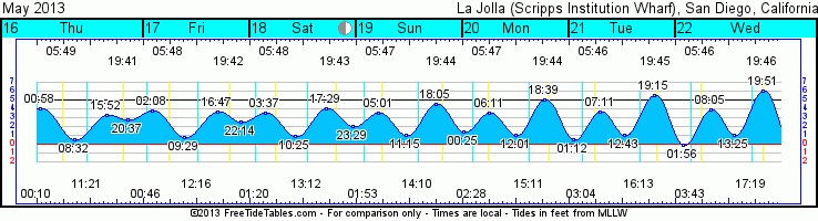
Tides for La Jolla (Scripps Institution Wharf
Day High Tide Height Sunrise
/Low Time Feet Sunset Visible
Th 16 High 12:58 AM 4.1 5:49 AM Set 12:11 AM 27
16 Low 8:32 AM 0.6 7:42 PM Rise 11:21 AM
16 High 3:52 PM 3.3
16 Low 8:37 PM 2.8
F 17 High 2:08 AM 3.8 5:48 AM Set 12:46 AM 36
17 Low 9:29 AM 0.8 7:43 PM Rise 12:16 PM
17 High 4:47 PM 3.7
17 Low 10:14 PM 2.6
Sa 18 High 3:37 AM 3.5 5:48 AM Set 1:20 AM 46
18 Low 10:25 AM 0.9 7:43 PM Rise 1:13 PM
18 High 5:29 PM 4.0
18 Low 11:29 PM 2.0
Su 19 High 5:01 AM 3.5 5:47 AM Set 1:54 AM 56
19 Low 11:15 AM 1.0 7:44 PM Rise 2:11 PM
19 High 6:05 PM 4.5
M 20 Low 12:25 AM 1.4 5:46 AM Set 2:28 AM 66
20 High 6:11 AM 3.6 7:45 PM Rise 3:11 PM
20 Low 12:01 PM 1.0
20 High 6:39 PM 5.0

