Showing posts with label Surfrider. Show all posts

Sunday, December 8, 2013

A little chilly surf!


Salutations!  A new NW wind swell is on its way in with some waist/chest high surf along the coast for Monday morning.  The not-so-good news is that we’re looking at some NW winds to kick up as well and a blustery day will make mincemeat out of whatever swell there is.  Tuesday the swell backs off rather quickly with waist high to start the day and ankle/knee high to end the day.  Wednesday is looking up for some new waist high surf out of the NW that should stick around all day and half way through Thursday.  The second half of Thursday things taper off and Friday we’re back into the really small stuff with knee high surf and interestingly some background SW swell…yes, SOUTHWEST swell. The better summer beaches will really only see an occasional waist high set out of it but we’ll take anything at this point eh? Saturday we’ll see some SW in the morning but for the most part we’re looking at NW wind swell in the knee high range that will move on into Sunday.  The tail end of Sunday should see some new NW groundswell making its way onto our shores.  At this point it’s looking like waist high waves at best but we’ll have to re-evaluate in a few days. 

Weather wise we’re looking at some pretty chilly weather with the dawn and sunset patrols taking a beating!  Brutally chilly air temps in the mid to low 40s a night and east winds overnight make for insanely cold dawn patrols this week.  Daytime temps along the coast only make it up into the low 60s. Skies will be clear so at least we’ll see sunshine all week.  Monday will have some significant west winds with gusts up to 25mph.  Through the week middays it looks like we’ll have some moderate westerly winds.  Water temps are consistently in the low 60s which will feel warm compared to the brisk morning and evening air.  Tides are fairly flat for most of the day with a medium low first thing in the morning moving to a medium high just after midday/mid-afternoon before moving out to a pretty low tide a few hours after nightfall.

Tough call on the surf with a little bit to work with and some chilly winter air temps. Best bring some rubber to the beach this week!

Stay wet San Diego!
Mish

Ocean Notes:
1)      I don’t know about you but I NEVER get tired of seeing perfect…or near perfect Pipeline even if there are 70 guys out. 

2)    Star Trek meets Foodieville.  A group in Barcelona is working on a 3D printer that prints…yes, “fresh” food.  Beam me…and my pizza…up Scotty!

3)    Stick this one on your calendar…December 18th is the Surfrider Volunteer Appreciation Party Stone Brew in Liberty Station.  Want to thank Surfrider’s Volunteers for your clean water and clean beaches?  Hit up the holiday party and get some beverages, tasty treats and live homegrown music!

4)    Tired if flat surf?  Head to the mountains to keep those legs in shape!  Mammoth has 12-16” of freshies to give them a nice 25-30” base!  Get carving San Diego!  For current conditions click here.

5)    And just in case you didn’t know…tulips aren’t the only thing going on in Holland !  How about some mega-cold waves!  Ok, so maybe December in Lake Michigan might be better than Holland but who knew?

Tides for La Jolla (Scripps Institution Wharf) starting with December 8, 2013.

www.saltwatertides.com
Day        High      Tide  Height   Sunrise    Moon  Time      % Moon
           /Low      Time    Feet    Sunset                    Visible
 
Su   8     High   1:48 AM     4.3   6:40 AM    Rise 11:18 AM      30
     8      Low   7:18 AM     2.3   4:43 PM     Set 11:20 PM
     8     High   1:06 PM     4.4
     8      Low   7:54 PM     0.3
 
M    9     High   2:53 AM     4.6   6:40 AM    Rise 11:55 AM      41
     9      Low   8:55 AM     2.0   4:43 PM
     9     High   2:34 PM     3.9
     9      Low   8:55 PM     0.7
 
Tu  10     High   3:52 AM     4.9   6:41 AM     Set 12:22 AM      52
    10      Low  10:25 AM     1.5   4:43 PM    Rise 12:31 PM
    10     High   4:07 PM     3.6
    10      Low   9:55 PM     1.1
 
W   11     High   4:44 AM     5.2   6:42 AM     Set  1:22 AM      63
    11      Low  11:35 AM     0.9   4:43 PM    Rise  1:07 PM
    11     High   5:31 PM     3.5
    11      Low  10:50 PM     1.4
 
Th  12     High   5:29 AM     5.5   6:43 AM     Set  2:21 AM      72
    12      Low  12:28 PM     0.3   4:44 PM    Rise  1:44 PM
    12     High   6:37 PM     3.6
    12      Low  11:38 PM     1.6
 

Thursday, August 22, 2013

Hiccup of S, then a bit more


There’s a light at the end of the tunnel…and it’s been a long tunnel!!!  We’re looking at a small new S swell to fill in for Friday Funday.  Don’t expect miracles but look for the occasional waist high wave at a south facing beach near you.  Waves stay in the knee to waist range all day then tapers off Sat with the ever lingering NW wind swell on top.  Sunday we’ll see more knee high surf with a bit more NW wind swell Monday.  There could be the occasional waist/chest high wave from the Tropical Depression “Nine” that’s heading our way but the angle is really aimed SE which means it should mostly fly right past us.  The more northerly summer breaks might catch a hint of it.   Otherwise, surf in the knee/waist high range with shorter periods from the windswell.  Tues and Wed is looking knee high again BUT Thursday looks like we’ll have some new SW groundswell and it might actually bump our swell past the waist high range.  We might actually see some chest high surf from this one.  It’s still a week away so we’ll have to see what happens to the storm creating this swell.  Think positive!!!

Speaking of Friday Funday we’re looking at a mighty fine beach day Friday with sunny skies, lots of heat and humidity too!  There’s a wee tropical depression down south that’s making its way towards us and pushing the clouds away and bumping up the tropical humidity for a few days.  Friday and Sat look for mostly sunny skies and air temps in the mid to high 70s.  Sunday and the rest of the week should be in the mid 70s with a few more clouds until Tues then clear skies and sunshine!  We could have a thundershower or two and maybe even the random hail Sunday night and thru Monday but those models are backing off so we might just have some cool looking thunderheads.  Water temps are all over the map with warm water in the low 70s in the northern end of the county and some chilly mid to low 60 degree water down south.  Tides are swinging a lot with the Blue Moon we had last night.  We’re looking at a zero tide an hour before sunrise moving up to a pretty high tide midday and then back out again for the sunset session (good for a Friday evening walk on the beach!) and then back up to a high around midnight. 

Looks like some tiny waves for the gorgeous weekend but hopefully something on the way for the Labor Day weekend!

Stay wet San Diego!
Mish

Ocean Notes:
1)  Tahiti has been seeing some fun waves for the Billabong Pro…nothing monstrous but perfect, beautiful and pro surfers ripping them left and right…well, left anyway.  Check out Adrian Buchan  as he takes out Slater in the finals!

2) Surfrider’s at it again. Always cleaning up our beaches!  Go ahead and join in the fun this weekend in PB!  Click here for more info and details on other beach clean ups this fall!

3)  One of the greatest super foods for surfers to power up before or after a great surf session is beans.  “Bean, beans…good for the heart…” isn’t that how it goes?  Anyway, Treehugger  has some great recipes for beans and lentils.  Fuel up before paddling out!

4)  If you are looking to kill some time check out photographer Rob Gilley’s blog on Surfer Mag’s site.  Not only are there some great photos but some interesting insight as to how surfing has touched people all over the world…how the stoke has fueled folks in all walks of life and in tough times.  Check it out!

5)  This Sunday is the Leucadia Artwalk  from 10am – 5pm.  One of the cool local artists owns Swell Stuff wetsuit sales and repair.  Check out the swell hand knit beanies and other surf accessories while you’re in there.  Wetsuits on sale, consignment shop and even wetsuit recycling!!!  And bonus…local artist Golden Poppy Design  will be at Swell Stuff too!  Awesome handcrafted jewelry from local surfer girl Poppy deAnda.

6)  And to end on something totally surfy…Jon Jon and Buchan in Tahiti…doesn’t get much more surfy  than that right now!


Tides for La Jolla (Scripps Institution Wharf) starting with August 23, 2013.

www.saltwatertides.com
Day        High      Tide  Height   Sunrise    Moon  Time      % Moon
           /Low      Time    Feet    Sunset                    Visible
 
F   23      Low   5:09 AM     0.0   6:18 AM     Set  9:05 AM      95
    23     High  11:28 AM     5.4   7:25 PM    Rise  9:01 PM
    23      Low   5:32 PM     0.7
    23     High  11:40 PM     5.0
 
Sa  24      Low   5:44 AM     0.6   6:19 AM     Set 10:07 AM      90
    24     High  12:07 PM     5.3   7:24 PM    Rise  9:38 PM
    24      Low   6:24 PM     1.0
 
Su  25     High  12:29 AM     4.3   6:19 AM     Set 11:06 AM      82
    25      Low   6:20 AM     1.3   7:22 PM    Rise 10:17 PM
    25     High  12:48 PM     5.2
    25      Low   7:23 PM     1.2
 
M   26     High   1:28 AM     3.7   6:20 AM     Set 12:04 PM      74
    26      Low   6:58 AM     1.9   7:21 PM    Rise 10:58 PM
    26     High   1:36 PM     4.9
    26      Low   8:37 PM     1.5
 
Tu  27     High   2:51 AM     3.1   6:21 AM     Set 12:59 PM      64
    27      Low   7:45 AM     2.4   7:20 PM    Rise 11:41 PM
    27     High   2:35 PM     4.6
    27      Low  10:11 PM     1.5
 

Wednesday, May 15, 2013

Windy then Southern Hemi South!

Okeee dokee…it looks like we’ve got some decent NW windswell with a hint of S swell going on right now.  The S is really aimed more south of us but the better summer spots might pick up a dribble of waves every now and then.   Wind swell waves in the waist high range with the occasional chest high set.  Waves don’t have a lot of gusto to them but are surfable and pretty fun with not a lot of folks out for the most part.  Look for decreasing swell for Thursday and Friday with increasing winds so messier conditions out of the S and W.  Saturday is more of the same…waist high wind chop with conditions cleaning up a bit for Sunday. Late Sunday we’ll start to see the very start of the first big S swell.  This bad boy is kickin’ some butt down in the South Pacific right now.  Things will pick up Monday with very inconsistent SW swell in the chest/shoulder range.   Some background steep S swell from the year’s first hurricane, Alvin.  The angle of the hurricane looks like it will by-pass most of SD County but North County, OC and LA should see additional energy on top of the SW groundswell.  Things kick in more on Tuesday with more solid shoulder/HH surf especially at the better summer spots…some nice HH/OH sets there.  Plenty of surf through the week as a secondary SW swell keeps the surf pumping Wed. (more shoulder/HH+ surf) and starting to taper off a little on Thursday.  Looks like we’ve got more SW on tap and even a late NW storm that looks to be sending us some late season NW swell towards the end of next week.

The next few days and through the weekend look to be funky with a mix of clouds and steady SW winds.  Worst winds look like Thursday night into Saturday morning.  Booooooooooooooooo!  Even a chance of drizzle Thursday evening through midday Saturday.  Things start to clear up Sunday with early fog then clearing skies.  Air temps only in the mid to high 60s.  Water temps are pretty balmy with average temps in the low/mid 60s.  With the messy S winds I would expect those temps to drop a little over the weekend.  Luckily that slew of SW groundswells should bump it right back up over the course of next week.  Pretty low tides in the morning with mild water movement as it head up to a medium high tide in the late afternoon and very little movement to the medium low tide a little after sunset.

Looks like less than ideal conditions for surf over the next few days and through the weekend but some fun stuff coming up for next week!

I feel summer coming on!
Stay wet San Diego!
Mish

Ocean Notes:

1) The butt kickin’ S swell that’s heading our way is pumping out some insanity on Teahupoo.  Not only were the waves going RICHTER, there were folks going over the falls, Laird on a SUP, boats crashing into each other and barely making it over the lip, lost passengers, and jet skis, surfers, photogs and all trying to stay out of each other’s way.  Total Teahupoo insanity!

2)      More warm water video coming out of the Caribbean…oh, to be in that gorgeous blue water with beautiful barreling waves!

3)      Locally we’ve got some fun stuff going on.  This Friday at the Patagonia shop in Cardiff you can come see Thomas Campbell’s slide show and book signing with Dan Malloy.  Live music from Mattson 2.  Call the shop for more info – 760-634-9886.

4)      Put the Patagonia Board Swap on your calendar for June 1st starting at 8am.  You can call to reserve your spot to swap/sell your board or just stop by to check out the goods!  Always some great deals to be had here!

5)     And if you’d like to support you local Surfrider Chapter how about heading to En Fuego in Del Mar on May 29th.  Ten percent of their sales will go to Surfrider and you benefit with tasty food and delicious beverages!  For more info click here!

6)      And just to get you in a summery mood here’s a great recipe for some summer asparagus salad . I’ve also done a similar recipe with a squeeze of fresh Meyer lemon and roasted sliced almonds.

7)      And I’ll end it with some fun local surf from that swell about a week ago.  The Bu woke up, Santa Cruz and Trestles was fun and there were still secret spots with hardly a soul out!  Offshore and S swell…yes, summer’s on it’s way!


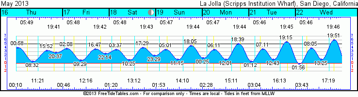
Tides for La Jolla (Scripps Institution Wharf) starting with May 16, 2013.

Day        High      Tide  Height   Sunrise    Moon  Time      % Moon
           /Low      Time    Feet    Sunset                    Visible
 
Th  16     High  12:58 AM     4.1   5:49 AM     Set 12:11 AM      27
    16      Low   8:32 AM     0.6   7:42 PM    Rise 11:21 AM
    16     High   3:52 PM     3.3
    16      Low   8:37 PM     2.8
 
F   17     High   2:08 AM     3.8   5:48 AM     Set 12:46 AM      36
    17      Low   9:29 AM     0.8   7:43 PM    Rise 12:16 PM
    17     High   4:47 PM     3.7
    17      Low  10:14 PM     2.6
 
Sa  18     High   3:37 AM     3.5   5:48 AM     Set  1:20 AM      46
    18      Low  10:25 AM     0.9   7:43 PM    Rise  1:13 PM
    18     High   5:29 PM     4.0
    18      Low  11:29 PM     2.0
 
Su  19     High   5:01 AM     3.5   5:47 AM     Set  1:54 AM      56
    19      Low  11:15 AM     1.0   7:44 PM    Rise  2:11 PM
    19     High   6:05 PM     4.5
 
M   20      Low  12:25 AM     1.4   5:46 AM     Set  2:28 AM      66
    20     High   6:11 AM     3.6   7:45 PM    Rise  3:11 PM
    20      Low  12:01 PM     1.0
    20     High   6:39 PM     5.0
 

Tuesday, April 9, 2013

Springtime wind and windswell


WHOA!  How about that wind?  I was not expecting that much wind.  Too bad it made such a mess of all that beautiful swell.  Well, that’s Springtime in SoCal for ya!  Looks like we’ve got more lumpy swell with the leftover the NW wind swell to give us some slightly cleaner surf for Wed.  Surf still decent size in the chest/shoulder range but dropping through the day.  Thursday looks waist high with some background S swell but most of that will miss SD County and overnight winds looks to make things pretty messy.  Friday looks like a little more NW windswell with size keeping in the waist/chest range with the occasional shoulder high set.  Saturday the swell backs down pretty quickly and surf drops to knee/waist high.  Sunday is about the same with some longer period but fairly steep S swell starts to build in.  That swell will have some pretty nice energy but will mostly miss SD due to the steep angle.  Far North County and OC/LA areas will see the best that swell has to offer.  We hope to see some stragglers from that one.  That swell builds Monday and doesn’t peak until about Tuesday with some sizable shoulder/HH surf and OH sets not uncommon by Tuesday in the LA area.

Definitely seeing some springtime weather with winds all over the place…onshore…offshore…side shore…all in a 24hr period.  More of the same all week with some clear skies for Wed/Thurs and slightly warmer air temps (high 60s) before the marine layer and a little midday sunshine comes back for the weekend.  Tough to see the good wind windows…I’m thinking mid-Thurs morning we might see some SE winds but overnight NW winds might make it just a jumbled mess.  Friday morning doesn’t look too bad with SE winds overnight.  Some cooler water temps in the high 50s…maybe feeling a little cooler with the super low tides in the early morning this weekend.  Still some big tide swings from the medium high to the mid-afternoon low for the next day or so before things start to even out. 

So I think this next week will just be a week of “just GO” cause it’ll never be super clean but just degrees of more or less clean.

Have fun and stay wet San Diego!
Mish


Ocean Notes:

1)      Is what you do extreme?  You might think twice after checking out these daredevils…secret spot highlining.  Shoot, what’s 192’ up in the air on a thin rope?

2)    Hey, tickets to Surfrider’s 13th Annual Art Gala are on sale!  They’ve got a new look and live artists!  Tickets are only $50 and that includes the event, food AND drinks! WHAT?  Get your tickets now!

3)    With summer close on our heels and those pallet bonfires looking more enticing every day it’s time you learned which pallets are safe and which are not. Not safe?  Who knew?

4)    If you missed the first few showings of Jack McCoy’s Deeper Shade of Blue there’s still time!  It’s still showing at La Paloma Theater in Encinitas thru Thursday April 11th!  Beautifully show and some insane footage...old and new, telling the story of surfing! Here’s the trailer!  http://www.youtube.com/watch?v=Gr5SxtOP_W4

5)    Gotta end on a surfy surfy note…late NW swell…Pipeline…need I say more?


Tides for La Jolla (Scripps Institution Wharf) starting with April 10, 2013.

www.saltwatertides.com
Day        High      Tide  Height   Sunrise    Moon  Time      % Moon
           /Low      Time    Feet    Sunset                    Visible
 
W   10      Low   3:56 AM    -0.4   6:25 AM    Rise  6:26 AM      0
    10     High  10:08 AM     4.4   7:16 PM     Set  7:53 PM
    10      Low   3:45 PM     0.7
    10     High   9:59 PM     5.5
 
Th  11      Low   4:32 AM    -0.5   6:24 AM    Rise  7:03 AM      0
    11     High  10:46 AM     4.0   7:16 PM     Set  8:49 PM
    11      Low   4:14 PM     1.1
    11     High  10:28 PM     5.4
 
F   12      Low   5:08 AM    -0.3   6:22 AM    Rise  7:43 AM      2
    12     High  11:26 AM     3.8   7:17 PM     Set  9:44 PM
    12      Low   4:41 PM     1.4
    12     High  10:57 PM     5.2
 
Sa  13      Low   5:46 AM    -0.1   6:21 AM    Rise  8:25 AM      5
    13     High  12:08 PM     3.4   7:18 PM     Set 10:37 PM
    13      Low   5:08 PM     1.7
    13     High  11:27 PM     5.0
 
Su  14      Low   6:29 AM     0.2   6:20 AM    Rise  9:10 AM      11
    14     High  12:59 PM     3.1   7:19 PM     Set 11:26 PM
    14      Low   5:35 PM     2.1
 

Tuesday, February 19, 2013

Rain but it's the wind...


Here she comes!  No, not the rain, well, ok some rain but it’s the swell I’m talking about.  We’ve got some NW groundswell on the way for Wednesday. The buoys are picking up steadily with 20 second periods on the local buoys.  The big spoiler will be the wind that’s about to blast through and make chop liver out of everything. We’re looking at surf to pick up into the chest high range tonight with super inconsistent sets in the shoulder high range by Wednesday morning.  Through the day the swell will pick up but the windswell is going to really jump by midday and I’m expecting things to be big but messy as this cold storm moves through.  Wave heights hitting well overhead by sundown but winds gusting to 35mph.  Big windswell sticks around for Thursday morning but winds will die down.  The windswell diminishes all day with chest/shoulder high surf by sunset.  That groundswell will technically still be in the background but it’ll taper off to waist/chest by Friday morning and then waist high by evening.  Smaller WNW swell for Sat with waist high surf.  A new shorter period groundswell looks to fill in for Sunday with a little more windswell on top of it.  Waves in the waist/chest range for the early morning session bumping up to chest/shoulder by sundown.  Monday morning actually looks decent with calmer winds, less windswell and the tail end of a NW groundswell.  Size in the waist/chest range with some shoulder high sets sneaking in through the morning.  Some interesting smaller bursts of WNW swells look to be lining up across the North Pacific. Not huge by any means but some consistent surf to play on.  We’ll see how those little buggers pan out over the next few days.

Oh, the weather…what shall we do with the weather.  Well, technically as I type it’s raining but it’ll probably be over by the time I finish this sentence.  The big story here at the coast is the cold air temps and wind.  LOTS of gusty winds.  Forecast says hail and thunderstorms too. WOOHOOOOOO!  But don’t blink or you’ll miss it!  The bulk of the worst rain and wind will be overnight and then some stiff 15-20mph winds with gusts to 35mph during the day Wednesday.  Winds and chances of rain decrease Wed night.  A second little spritz of rain might squeeze out of a cloud or two Thursday but we’ll see mostly clouds.  Clearing and mostly sunny as we slide into the weekend. Air temps will be cold though…mid50s through Thursday and then highs in the low 60s for Fri/Sat.  The nicest day will be Sun/Mon…sunny and mid/high60s along the coast.  Water temps are in the mid50s.  Tides are working their way towards the more extreme side as we approach the full moon.  Medium high dawn patrol tide will drain out to a midday low near zero feet then back up for a medium sunset tide.  We’re past the King Tide phase so the weekend extreme highs won’t be too bad nor will the drained out afternoon lows.

Surf’s probably gonna be a mess for a few days…weekend looks like of fun though!

Stay wet (but warm) San Diego!
Lates,
Mish

P.S.  It's still raining!  :-)

Ocean Notes:

1)      Not sure why I haven’t posted about Wildcoast yet but this group does a lot of great work to help keep our coastline clean.  They work mostly in the southern end of the county along the border and have Chapters thoughout Baja California. They’re sponsoring a beach cleanup this weekend down in the Tijuana Slough Wildlife Refuge. Check ‘em out and lend them a hand!  It’s your ocean too!

2)    And while we’re on the topic of ocean protection why not check out CoastKeeper’s beach clean up calendar?

3)    Don’t worry I’m not forgetting Surfrider San Diego!  Their advocacy work has led to the protection of many great SD County surf breaks…not to mention great events like the V Elements Festival in April.  What’s that?  Click here and find out!

4)    Surfline and Waterways Surf Adventures are sponsoring a contest for best user-submitted travel slideshow.  Here's  the latest from Baja…fun sliders and some ripping surf! 

5)    I’ll send on a super surfy note… Pipeline Perfection.


Tides for La Jolla (Scripps Institution Wharf) starting with February 20, 2013.

www.saltwatertides.com
Day        High      Tide  Height   Sunrise    Moon  Time      % Moon
           /Low      Time    Feet    Sunset                    Visible
 
W   20     High   5:25 AM     4.5   6:27 AM     Set  2:41 AM      68
    20      Low  12:43 PM     0.2   5:39 PM    Rise  1:14 PM
    20     High   7:22 PM     3.3
    20      Low  11:59 PM     2.1
 
Th  21     High   6:10 AM     4.9   6:26 AM     Set  3:25 AM      76
    21      Low   1:11 PM    -0.1   5:40 PM    Rise  2:07 PM
    21     High   7:41 PM     3.6
 
F   22      Low  12:39 AM     1.7   6:24 AM     Set  4:06 AM      84
    22     High   6:48 AM     5.2   5:41 PM    Rise  3:02 PM
    22      Low   1:38 PM    -0.4
    22     High   8:01 PM     3.9
 
Sa  23      Low   1:15 AM     1.4   6:23 AM     Set  4:45 AM      90
    23     High   7:24 AM     5.3   5:41 PM    Rise  3:59 PM
    23      Low   2:04 PM    -0.6
    23     High   8:24 PM     4.1
 
Su  24      Low   1:49 AM     1.1   6:22 AM     Set  5:21 AM      95
    24     High   7:58 AM     5.4   5:42 PM    Rise  4:58 PM
    24      Low   2:30 PM    -0.6
    24     High   8:49 PM     4.4