Showing posts with label Kelly Slater. Show all posts

Tuesday, March 12, 2013

In for a week of small surf...really small.


Aloha fellow surfers!  I hope you’ve enjoyed the past few days of surf because things are going to be kind of small for a while.  We’re looking at knee to waist high waves out of the NW and a little out of the SW next week.  It’ll be a week of small or smaller?  How big a board to you have?  The northern hemisphere is quieting down as we find the southern hemi waking up a bit.  Wednesday through the weekend we’re looking at knee/waist high waves.  Next Tuesday it looks like a small SW swell will show up to give us a little reprieve with some waist high waves at the better summer beaches.  The southern hemi looks like it’s going to throw us a few more bones and hopefully the northern hemi will spit out a few more juicy swells before it’s done for the Winter.  Sorry not much to report…

The good news is that the weather looks like it’s going to be rain-free for at least the next week.  With the cool water and high pressure system keeping the inland air temps warm we’re due for some fairly consistent marine layer this week.  That means fog in the morning and evenings and scattered sunshine midday and into the afternoon.  Morning winds will be out of the NE through the end of the week with afternoon winds turning out of the W.  Weekend looks like we might see a bit more onshore wind earlier in the day.  Tides are coming off the new moon Monday so we’re coming off a negative high tide for the dawn patrol and have a medium high tide in the late morning before going out to a medium low tide in the late afternoon. Luckily with the time change we now have time to surf before the sun sets after work.  Water temps are trying to warm up ever so slightly with the small south swells rolling in.  The last bit of wind cooled them down but with the next set of souths we should see an increase of a few degrees.

Looks like some good clean conditions for logging or SUPping.  Watch out for that fog and don’t get lost!
I’m outta here!
Mish

Ocean Notes:
1)     Kirra =  Kelly and his 52nd career win!  The mags are making us wait for photos and video on this one but the story is here.
 
2)   We can, however, watch the quarter finals and some pretty darn good surfing at Snapper Rock.

3)   Puerto Rico…it’s not just for rum anymore!

Tides for La Jolla (Scripps Institution Wharf) starting with March 13, 2013.
Day        High      Tide  Height   Sunrise    Moon  Time      % Moon
           /Low      Time    Feet    Sunset                    Visible

W   13      Low   4:47 AM    -0.1   7:01 AM    Rise  7:52 AM      1
    13     High  10:56 AM     4.6   6:56 PM     Set  9:07 PM
    13      Low   4:51 PM     0.3
    13     High  11:07 PM     5.2

Th  14      Low   5:27 AM     0.1   7:00 AM    Rise  8:28 AM      4
    14     High  11:36 AM     4.1   6:56 PM     Set 10:04 PM
    14      Low   5:19 PM     0.8
    14     High  11:38 PM     5.0

F   15      Low   6:10 AM     0.3   6:59 AM    Rise  9:06 AM      9
    15     High  12:19 PM     3.6   6:57 PM     Set 11:00 PM
    15      Low   5:46 PM     1.4

Sa  16     High  12:11 AM     4.7   6:57 AM    Rise  9:47 AM      16
    16      Low   6:58 AM     0.7   6:58 PM     Set 11:54 PM
    16     High   1:10 PM     3.0
    16      Low   6:12 PM     1.8

Su  17     High  12:48 AM     4.4   6:56 AM    Rise 10:30 AM      24
    17      Low   7:59 AM     1.0   6:59 PM
    17     High   2:25 PM     2.7
    17      Low   6:37 PM     2.2

Sunday, September 23, 2012

More surf...S AND NW...!


Greetings Earthlings!  Looks like we’re coming off some pretty small swell but will start the week of right with some building SW groundswell Monday and our first NW groundswell starting to fill in late Monday and into Tuesday (Just check the Pipeline cams if you don't believe me!).  Surf looks to be only thigh/waist high Monday morning with some slightly bigger waist high surf by the evening out of the NW.  Tuesday morning will see waist high surf building through the day to waist/chest and peaking late in the day with the occasional shoulder high wave at the better N facing winter spots.  I would hardly call it “Opening Day” but it’s definitely the first good NW groundswell that’s popped up from the Aleutians.  Wed things start to back off as we see some background surf from Hurricane Miriam as she heads NW.  This is a very good thing as right now she’s a little too far SE so the swells will start off too steep for most of SD (OC and LA I’m talking to you here!) but if she moves up in the forecasted path then we should see some pretty nice hurricane swell in the chest/shoulder range by Thurs and Fri with swell peaking in the occasional HH range at more of the SD beaches by Sat.  It’ll never be SW mind you so still hit the better summer spots to take advantage of this swell.  The good news is there is another SW ground swell that looks to be heading into our swell window.  This one looks to have some kick in it as the storm that created it is sitting in our window and is just sitting there stirring up swell. Look for surf to bum up next Sunday throughout the county…Saturday afternoon and Sunday.  As the week passes I’ll keep you updated on how that swell is going to show up…don’t want this to just be another “internet hype” swell eh?

The Fall weather is upon us…sort of.  We’re still going to see some pretty nice temperatures in the high 70s along the coast but we’ll also see a bit more onshore west wind midweek as the high pressure system breaks down a little, temperatures cool and the system that created that NW groundswell nudges us a little.  I don’t think we’ll actually see water fall from the sky just yet but we might see a few more clouds for the latter part of the week.  The best part is that we’ll see cooler nighttime temps Mon-Thurs…much more pleasant sleeping weather.   The morning sessions look like they might have a little light offshore for the first few days of the week before the breezes pick up.  Nice!  And as we near the Full Moon on Saturday we’re going to start seeing a bit more water movement throughout the week.  We’ll start with medium high early AM, medium low midday to big high at sunset and then see more extreme movement by Wed.  Water temps are trying to warm up but we’re still seeing the high 60sa and low 70 here and there with slightly warmer temps in N. County in the mid 70s.  I’m hoping this steep hurricane swell combo’d with the NW groundswell doesn’t cool things down too much this week.

Looks like a fun week of surf on into the weekend.  The early and sunset sessions might be your best bet as winds might become an issue midday.  Enjoy it…this is the best part of the year (if you ask me!).

Lates,
Mish

Ocean Notes:

1)       This Wednesday catch Taylor Steele’s This Time Tomorrow at La Paloma Theater at 8pm.  You can’t beat the combo of a Taylor Steele surf flick with Dave Rastovich and Craig Anderson tracking a Pacific swell.  Gonna be some fine surfing!  Catch it!

2)      Here’s a good one…have you been munching on the pricey water-grown veggies from your local farmer’s market?  Well now you can do hydroponic gardening thanks to IKEA!  Yes, just click on the link…you’ll be pleasantly surprised!

3)      Put this on your calendar…the Patagonia store in Cardiff will be having another Board Swap on Sat. October 13th from 8-noon.  Email store_cardiff@patagonia.com to reserve a spot. It’s free to have your boards there and Patagonia doesn’t take a cut.

4)      Yup, Slates sets another record for us to gawk at…50 WCT wins with #50 happening last week at Trestles in some inconsistent and fading S swell but it was enough to get the man his trophy.  Must be nice!

5)      And here’s more eye candy to end these notes…crankin’ Tassie surf…big and cold.  Dang…I mean BIG AND COLD!


Tides for La Jolla (Scripps Institution Wharf) starting with September 24, 2012.

www.saltwatertides.com
Day        High      Tide  Height   Sunrise    Moon  Time      % Moon
           /Low      Time    Feet    Sunset                    Visible
 
M   24     High   6:41 AM     4.0   6:39 AM     Set  1:16 AM      61
    24      Low  11:42 AM     2.5   6:42 PM    Rise  3:18 PM
    24     High   5:47 PM     5.2
 
Tu  25      Low  12:42 AM     0.1   6:40 AM     Set  2:19 AM      72
    25     High   7:20 AM     4.5   6:41 PM    Rise  3:58 PM
    25      Low  12:45 PM     1.9
    25     High   6:48 PM     5.3
 
W   26      Low   1:24 AM     0.0   6:40 AM     Set  3:20 AM      81
    26     High   7:52 AM     4.9   6:40 PM    Rise  4:34 PM
    26      Low   1:34 PM     1.4
    26     High   7:38 PM     5.4
 
Th  27      Low   2:00 AM     0.1   6:41 AM     Set  4:20 AM      88
    27     High   8:21 AM     5.2   6:38 PM    Rise  5:08 PM
    27      Low   2:15 PM     0.9
    27     High   8:22 PM     5.4
 
F   28      Low   2:32 AM     0.2   6:42 AM     Set  5:19 AM      94
    28     High   8:49 AM     5.4   6:37 PM    Rise  5:41 PM
    28      Low   2:53 PM     0.6
    28     High   9:02 PM     5.2
 

Friday, July 20, 2012

Some fun SW late Sat and into Sun


Hola SoCal!  We’re seeing the tail end of some smaller SW swell that provided us with some surface peelers.  We’re looking at Saturday to start off small in the knee/waist high range but we should start to see that new SW by sundown.  Look for super inconsistent sets by sundown in the waist high range with slightly larger surf in the waist/chest range by Sunday morning and through the day.  Surf will pick up steadily through the day but really make it’s mark on Monday with waves in the chest high range and slightly bigger at the best summer spots.  Tuesday we’ll continue to see surf in the chest/shoulder range…farther N. County and OC/LA will see some HH surf.  Wednesday and Thursday will continue to see fun surf and then things will start to back down late Thursday and back into the waist/chest range for Friday.  The weekend looks smaller but the forecast is not grim.  Seems to be some more SW swell looming in the distance.  Small for next weekend but perhaps some new SW for the start of next week!

We’re seeing mostly clear skies as we wake up with minimal winds through the day.  Look for a lot of the same through the weekend.  The biggest change will be Sunday as the remnants of the last Hurricane Faaaaaaabio pass through town so we’ll see more humidity, some clouds and a chance of thunder storms.  Not much wind activity associated with that though so look for some nice beach and surf weather for the entire weekend and into next week.  Air temps in the mid to low 70s along the coast.  Some patch clouds in the morning but should burn off pretty early.  Water temps are fantastic…high 60s and low 70s everywhere.  Tides are pretty low (negative low) for the early morning dawn patrol with some decent but not extreme movement midday and then a nice push for the high tide for the sunset session.   Keep your eye out for the big black/purple jellies (you can’t miss ‘em) and sting rays.  Shuffle shuffle shuffle! 

Looking forward for some serious summer fun this weekend and well into the week!

Aloooooooooooooha!

Mish

Ocean notes:

1)  This Sunday is the Carlsbad Lagoon Day walk/Run to raise money to preserve the lagoon.  Don't worry, you don't have to do a marathon...there's a 1.2mile casual walk, 2 mile fun run/walk and 3.5 mile run/walk around Agua Hedionda lagoon.  All for fun and all routes end at the BBQ from Tip Top meats at the Discovery Center on Cannon Road.  For more info email lisa@aguahedionda.org or show up on the day of the event or click here for more info.

2)  This is awesome…if there’s anyone I would want leading me into the line up at Trestles it would be Kelly Slater…ESPECIALLY if I was blind!  Check out Slates and blind Brazilian surfer Derek Rabelo catching a few together.  Head high and really feeling the waves…sweet!


Tides for La Jolla (Scripps Institution Wharf) starting with July 21, 2012.

www.saltwatertides.com
 
Day        High      Tide  Height   Sunrise    Moon  Time      % Moon
           /Low      Time    Feet    Sunset                    Visible
 
Sa  21      Low   5:19 AM    -0.5   5:56 AM    Rise  8:30 AM      3
    21     High  11:47 AM     4.4   7:55 PM     Set  9:23 PM
    21      Low   5:08 PM     1.7
    21     High  11:11 PM     5.4
 
Su  22      Low   5:50 AM    -0.1   5:56 AM    Rise  9:31 AM      7
    22     High  12:23 PM     4.6   7:54 PM     Set  9:58 PM
    22      Low   5:57 PM     1.7
    22     High  11:53 PM     5.0
 
M   23      Low   6:24 AM     0.3   5:57 AM    Rise 10:33 AM      14
    23     High   1:02 PM     4.7   7:54 PM     Set 10:33 PM
    23      Low   6:56 PM     1.7
 
Tu  24     High  12:44 AM     4.3   5:58 AM    Rise 11:36 AM      23
    24      Low   7:00 AM     0.8   7:53 PM     Set 11:10 PM
    24     High   1:48 PM     4.9
    24      Low   8:10 PM     1.6
 
W   25     High   1:51 AM     3.6   5:58 AM    Rise 12:41 PM      33
    25      Low   7:42 AM     1.3   7:52 PM     Set 11:50 PM
    25     High   2:42 PM     5.1
    25      Low   9:39 PM     1.4

Wednesday, June 13, 2012

More NW wind swell and some small S too!


(I’m heading out on vacation so the next report won’t be until next Monday the 18th)

Oh boy it’s another holiday weekend coming up AND (sing it with me now…) “SCHOOOOOOOOOOOOL’S OUT FOR SUMMER!!!!!”  To kick off the first weekend of many kiddos summer vacation we’re looking at some combo WNW pseudo groundswell (ok, just call it wind swell) mixed in with some super long period SW groundswell.  For Thursday that translates into waist/chest high decently consistent surf at W and N facing beaches with very VERY inconsistent waist high surf at the S facing beaches.  A bit more S on Friday with decreasing WNW.  The weekend (Sat/Sun) is looking like mostly the left overs of the S swell so…hmmmmmm, waist/knee high.  The W and N facing beaches should see some tiny NW wind swell in the background.  Best to hit the beach breaks with a fun shortboard and the reefs with a log…a BIG log!  Late Monday is looking like the next opportunity for new swell with more NW wind swell showing up to help the toe high surf into the knee high range.  Luckily Tuesday we’re also looking at some new SW ground swell that looks to finally have a little gusto in it with surf picking up for the end of next week.  Again, that’s a ways off but the storm models look promising.

Our weather patterns seems sort of painfully steady with overcast skies sticking to the coastline and low to mid60s.  A small system will deliver a chance of drizzles tonight (yes, really!) with a bit more sunshine for Fri and Sat.  Father’s Day looks like a decently nice day with the warmest air temps all weekend (high 60s/low 70s) and maybe even some sunshine by midday.  We’ll have a little S winds tonight and early east winds before becoming westerly.  S winds on Thurs night and Fri as our pal “coastal Eddy” swoops into town for the day.  Nicer days with lighter S winds Sat and light W winds by midday Sun.  We’re seeing only minor tidal movement midday with big tide swings starting up around sunset (big high tides) and negative lows through the middle of the night.  Water temps have cooled off a tad with temps in the 64-66 degree range around the county.

I hope everyone has a nice Father’s Day weekend and if you’re getting out of school…have a great first summer weekend!

Outta here!
Mish

Ocean Notes:

1)       Here’s an app you might not have… Trash Backwards…an upp for UPCYCLING your garbage…do something with it before it heads to the recycling center!  Figure out what to do with just any anything you have that you might want to recycle!  Just try it…you’ll be surprised!

2)      And Dad probably doesn’t need ANOTHER pair of on-sale boardshorts.  Why not check out the Treehugger Green Gift Guide to give you some ideas.  Shoot…upcycle the boardshorts using the Trash Backwards app!

3)      Don’t forget about International Surfing Day on Wednesday June 20th!  Head over to Paradise Point Resort and Spa with the San Diego Surfrider for some fun eats, treats, beverages and the world premiere of Taylor Steele’s new surf flick Here & Now.

4)      And if you’re one of the thousands who will flock to the Fair this weekend also check out Surfrider’s award winning Ocean Friendly Garden display.  Get some good ideas for your own backyard while you’re there!

5)      Well, by now you might have heard that it was PUUUUUUUUMPING for the Volcom Pro in Fiji this past week.  If you don’t believe it then here’s the proof. Put your seat belt on cause this might just blow you AWAY!

6)      And I try to save the best for last…you’ll sleep soundly tonight dreaming about this…Kelly Slater just rocked the house and made it look so amazingly easy to rip during the finals of the Volcom Pro to win first place.  A-MA-ZING!!!


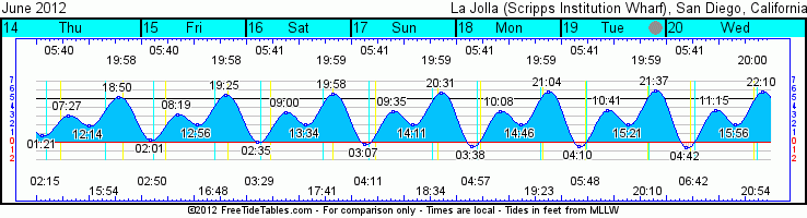
Tides for La Jolla (Scripps Institution Wharf) starting with June 14, 2012.

www.saltwatertides.com
Day        High      Tide  Height   Sunrise    Moon  Time      % Moon
           /Low      Time    Feet    Sunset                    Visible
 
Th  14      Low   1:21 AM     0.8   5:40 AM    Rise  2:15 AM      27
    14     High   7:27 AM     3.1   7:59 PM     Set  3:55 PM
    14      Low  12:14 PM     1.9
    14     High   6:50 PM     5.2
 
F   15      Low   2:01 AM     0.3   5:40 AM    Rise  2:50 AM      19
    15     High   8:19 AM     3.2   7:59 PM     Set  4:49 PM
    15      Low  12:56 PM     2.0
    15     High   7:25 PM     5.4
 
Sa  16      Low   2:35 AM     0.0   5:40 AM    Rise  3:28 AM      12
    16     High   9:00 AM     3.4   7:59 PM     Set  5:42 PM
    16      Low   1:34 PM     2.1
    16     High   7:58 PM     5.6
 
Su  17      Low   3:07 AM    -0.3   5:41 AM    Rise  4:10 AM      6
    17     High   9:35 AM     3.5   8:00 PM     Set  6:34 PM
    17      Low   2:11 PM     2.1
    17     High   8:31 PM     5.7
 
M   18      Low   3:38 AM    -0.5   5:41 AM    Rise  4:57 AM      2
    18     High  10:08 AM     3.6   8:00 PM     Set  7:24 PM
    18      Low   2:46 PM     2.1
    18     High   9:04 PM     5.8