Sunday, May 19, 2013

South swell is here all week!

Goodness…what fun swell we are having!  That SW groundswell that graced Teahupoo and the Hawaiian Islands the past few days has finally made it to our shores.  We’re seeing surf in the chest/shoulder high range out of the SW this evening with bigger sets at the better summer spots. There is some lingering NW windswell in the background so things aren’t quite as clean as they could be but it doesn’t seem to be hampering the surf any.  The new swell continues to fill in Monday as it peaks late morning.  Surf in the shoulder/HH range around most of town with HH/OH+ sets not uncommon at the south facing beaches.  I would imagine some of the better known summer spots will be a wee bit crowded for most of the day.  Plenty of surf Tuesday even as the swell backs off just a little.  Shoulder/HH surf throughout the day and on into Wednesday as a new little SW moves in to give the surf a continued boost.  Wednesday we’ll see some new WNW windswell move in as a small system that’s sitting offshore right now pushes it’s way east.  That will be accompanied by yet another SW groundswell.  Plenty of surf in the shoulder/HH and OH range for Thursday and finally starting to drop off for Friday.  Saturday looks to be the smallest day of the week with surf starting off in the waist high range but we’re looking at another medium sized SW swell that will send a little surf our way for the second half of the holiday weekend.  Wave heights look to bump back up onto the chest/shoulder range through the day Saturday and into Sunday.    Some smaller surf on the way after that swell as the S. Pacific starts to quiet down for a bit.

The good weather news is that we’ve got some pretty nice weather for most of the week. The best stuff is at the start of the week with mostly sunny skies after some early morning clouds.  That will be the story through Wed when a small low pressure system butts its head in and a few more clouds move I for the second half of the week.  We should still see plenty of midday sunshine though.  Air temps along the coast in the low 70s to start the week and down into the high to mid 60s for the middle and end of the week.  As it’s still technically Spring we’re going to continue to see some SW winds pickup by midday.  The morning’s look fairly calm so the dawn patrols should be pretty clean for this new swell.  As we head towards the Full Moon this weekend we’re looking at some more extreme tidal movement.  There’s a medium high in the early morning for the dawn patrol that goes to a medium low midday. Then we’ll see a moderate tide push for the late afternoon/early evening sunset session with a fairly decent high tide.

Some fun surf all week for everyone and for the holiday weekend as many kids kick off the start of summer vacation!

Stay wet this week!
Mish


Tides for La Jolla (Scripps Institution Wharf) starting with May 20, 2013.
Day        High      Tide  Height   Sunrise    Moon  Time      % Moon
           /Low      Time    Feet    Sunset                    Visible
 
M   20      Low  12:25 AM     1.4   5:46 AM     Set  2:28 AM      66
    20     High   6:11 AM     3.6   7:45 PM    Rise  3:11 PM
    20      Low  12:01 PM     1.0
    20     High   6:39 PM     5.0
 
Tu  21      Low   1:12 AM     0.6   5:46 AM     Set  3:04 AM      76
    21     High   7:11 AM     3.7   7:46 PM    Rise  4:15 PM
    21      Low  12:43 PM     1.1
    21     High   7:15 PM     5.5
 
W   22      Low   1:56 AM    -0.2   5:45 AM     Set  3:44 AM      85
    22     High   8:05 AM     3.9   7:46 PM    Rise  5:20 PM
    22      Low   1:25 PM     1.1
    22     High   7:51 PM     6.0
 
Th  23      Low   2:40 AM    -0.8   5:45 AM     Set  4:28 AM      92
    23     High   8:55 AM     4.0   7:47 PM    Rise  6:28 PM
    23      Low   2:07 PM     1.2
    23     High   8:30 PM     6.3
 
F   24      Low   3:24 AM    -1.4   5:44 AM     Set  5:18 AM      97
    24     High   9:45 AM     4.0   7:48 PM    Rise  7:36 PM
    24      Low   2:50 PM     1.3
    24     High   9:12 PM     6.6
 

South is filling in!

That south Seau swell is kicking in today. It's inconsistent but some nice chest high+ sets around town.  More update tonight during the weekly forecast...

Stay wet!

Mish

Wednesday, May 15, 2013

Windy then Southern Hemi South!

Okeee dokee…it looks like we’ve got some decent NW windswell with a hint of S swell going on right now.  The S is really aimed more south of us but the better summer spots might pick up a dribble of waves every now and then.   Wind swell waves in the waist high range with the occasional chest high set.  Waves don’t have a lot of gusto to them but are surfable and pretty fun with not a lot of folks out for the most part.  Look for decreasing swell for Thursday and Friday with increasing winds so messier conditions out of the S and W.  Saturday is more of the same…waist high wind chop with conditions cleaning up a bit for Sunday. Late Sunday we’ll start to see the very start of the first big S swell.  This bad boy is kickin’ some butt down in the South Pacific right now.  Things will pick up Monday with very inconsistent SW swell in the chest/shoulder range.   Some background steep S swell from the year’s first hurricane, Alvin.  The angle of the hurricane looks like it will by-pass most of SD County but North County, OC and LA should see additional energy on top of the SW groundswell.  Things kick in more on Tuesday with more solid shoulder/HH surf especially at the better summer spots…some nice HH/OH sets there.  Plenty of surf through the week as a secondary SW swell keeps the surf pumping Wed. (more shoulder/HH+ surf) and starting to taper off a little on Thursday.  Looks like we’ve got more SW on tap and even a late NW storm that looks to be sending us some late season NW swell towards the end of next week.

The next few days and through the weekend look to be funky with a mix of clouds and steady SW winds.  Worst winds look like Thursday night into Saturday morning.  Booooooooooooooooo!  Even a chance of drizzle Thursday evening through midday Saturday.  Things start to clear up Sunday with early fog then clearing skies.  Air temps only in the mid to high 60s.  Water temps are pretty balmy with average temps in the low/mid 60s.  With the messy S winds I would expect those temps to drop a little over the weekend.  Luckily that slew of SW groundswells should bump it right back up over the course of next week.  Pretty low tides in the morning with mild water movement as it head up to a medium high tide in the late afternoon and very little movement to the medium low tide a little after sunset.

Looks like less than ideal conditions for surf over the next few days and through the weekend but some fun stuff coming up for next week!

I feel summer coming on!
Stay wet San Diego!
Mish

Ocean Notes:

1) The butt kickin’ S swell that’s heading our way is pumping out some insanity on Teahupoo.  Not only were the waves going RICHTER, there were folks going over the falls, Laird on a SUP, boats crashing into each other and barely making it over the lip, lost passengers, and jet skis, surfers, photogs and all trying to stay out of each other’s way.  Total Teahupoo insanity!

2)      More warm water video coming out of the Caribbean…oh, to be in that gorgeous blue water with beautiful barreling waves!

3)      Locally we’ve got some fun stuff going on.  This Friday at the Patagonia shop in Cardiff you can come see Thomas Campbell’s slide show and book signing with Dan Malloy.  Live music from Mattson 2.  Call the shop for more info – 760-634-9886.

4)      Put the Patagonia Board Swap on your calendar for June 1st starting at 8am.  You can call to reserve your spot to swap/sell your board or just stop by to check out the goods!  Always some great deals to be had here!

5)     And if you’d like to support you local Surfrider Chapter how about heading to En Fuego in Del Mar on May 29th.  Ten percent of their sales will go to Surfrider and you benefit with tasty food and delicious beverages!  For more info click here!

6)      And just to get you in a summery mood here’s a great recipe for some summer asparagus salad . I’ve also done a similar recipe with a squeeze of fresh Meyer lemon and roasted sliced almonds.

7)      And I’ll end it with some fun local surf from that swell about a week ago.  The Bu woke up, Santa Cruz and Trestles was fun and there were still secret spots with hardly a soul out!  Offshore and S swell…yes, summer’s on it’s way!


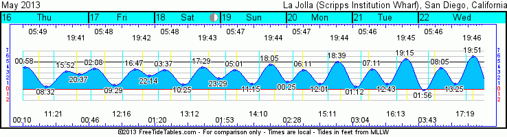
Tides for La Jolla (Scripps Institution Wharf) starting with May 16, 2013.

Day        High      Tide  Height   Sunrise    Moon  Time      % Moon
           /Low      Time    Feet    Sunset                    Visible
 
Th  16     High  12:58 AM     4.1   5:49 AM     Set 12:11 AM      27
    16      Low   8:32 AM     0.6   7:42 PM    Rise 11:21 AM
    16     High   3:52 PM     3.3
    16      Low   8:37 PM     2.8
 
F   17     High   2:08 AM     3.8   5:48 AM     Set 12:46 AM      36
    17      Low   9:29 AM     0.8   7:43 PM    Rise 12:16 PM
    17     High   4:47 PM     3.7
    17      Low  10:14 PM     2.6
 
Sa  18     High   3:37 AM     3.5   5:48 AM     Set  1:20 AM      46
    18      Low  10:25 AM     0.9   7:43 PM    Rise  1:13 PM
    18     High   5:29 PM     4.0
    18      Low  11:29 PM     2.0
 
Su  19     High   5:01 AM     3.5   5:47 AM     Set  1:54 AM      56
    19      Low  11:15 AM     1.0   7:44 PM    Rise  2:11 PM
    19     High   6:05 PM     4.5
 
M   20      Low  12:25 AM     1.4   5:46 AM     Set  2:28 AM      66
    20     High   6:11 AM     3.6   7:45 PM    Rise  3:11 PM
    20      Low  12:01 PM     1.0
    20     High   6:39 PM     5.0
 

Tuesday, May 14, 2013

Biiiiiiiiiiiiiiig Teahupoo!

Remember that HUGE Surfer Mag cover with Laird at Teahupoo that BLEW everyone’s mind?  This latest swell is right up in the “Mind blowing” category.  Some insanely huge waves hitting the South Pacific right now…and the good news is that it’s heading our way next!  YEAH BABY!  More details on that tonight…for now, just check out this link and HOLD ON!


http://www.surfline.com/surf-news/teahupoo-returns-part-one_96130/


Stay wet!

Mish


The information contained in this e-mail is intended only for the individual or entity to whom it is addressed.
Its contents (including any attachments) may contain confidential and/or privileged information.
If you are not an intended recipient you must not use, disclose, disseminate, copy or print its contents.
If you receive this e-mail in error, please notify the sender by reply e-mail and delete and destroy the message.

Thursday, May 9, 2013

Small S, wind swell and warm water!

Getting back to the grind!  This will be a quick one!  We’re getting a little bump up of SW swell overnight and into Friday with some waist high waves at the better summer spots along with some shorter period wind swell out of the west that will keep most beaches in the knee/waist high range, consistent but not a lot of guts.  Saturday looks like it starts small but another and slightly steeper SW swell fills in later in the day and into Sunday.  Surf for Sunday looks warm and sunny and in the waist/chest high range.  Swell peaks midday Monday and then we might see some funky S that’s really not aimed into our swell window but we’ll catch some dregs out of the S.  We will, however, see more WNW wind swell Tuesday and into Wed with some waist and even the occasional chest high set showing up in town.  Things taper off and slowly quiet own as that swell fades out during the second half of the week.  Good news is that the Southern Hemi is alive and well so it looks like we might see some nice SW groundswell in about a week and a half. 

Weather looks pretty nice for the weekend with decreasing clouds into the weekend, air temps in the high 60s to mid-70s along the coast.  Monday and Tuesday actually look the nicest with temps reaching the high 70s along the coast and plenty of sunshine.  Mild winds with the standard mild west wind kicking up for the afternoon and then calming again into nighttime.  Water temps are really nice with low to mid 60s around town. More warm stuff heading our way too!  New moon tides going on right now with early pre-dawn morning drained out lows, medium highs mid-morning, medium low mid-afternoon then zipping up with a big tide push for the evening sunset sessions.

Gotta go unpack and hit the sack…travel is good but I’m beat!
Stay wet San Diego!
Mish


Tides for La Jolla (Scripps Institution Wharf) starting with May 10, 2013.

Day        High      Tide  Height   Sunrise    Moon  Time      % Moon
           /Low      Time    Feet    Sunset                    Visible
 
F   10      Low   4:19 AM    -0.6   5:53 AM    Rise  6:21 AM      0
    10     High  10:41 AM     3.8   7:38 PM     Set  8:30 PM
    10      Low   3:42 PM     1.6
    10     High   9:57 PM     5.6
 
Sa  11      Low   4:53 AM    -0.5   5:53 AM    Rise  7:06 AM      0
    11     High  11:20 AM     3.6   7:38 PM     Set  9:21 PM
    11      Low   4:12 PM     1.8
    11     High  10:27 PM     5.4
 
Su  12      Low   5:29 AM    -0.4   5:52 AM    Rise  7:53 AM      3
    12     High  12:01 PM     3.4   7:39 PM     Set 10:08 PM
    12      Low   4:43 PM     2.1
    12     High  10:58 PM     5.2
 
M   13      Low   6:07 AM    -0.1   5:51 AM    Rise  8:42 AM      7
    13     High  12:47 PM     3.3   7:40 PM     Set 10:52 PM
    13      Low   5:16 PM     2.3
    13     High  11:31 PM     4.9
 
Tu  14      Low   6:50 AM     0.1   5:50 AM    Rise  9:34 AM      12
    14     High   1:42 PM     3.2   7:41 PM     Set 11:33 PM
    14      Low   5:57 PM     2.6
 

Sunday, April 28, 2013

First good South for San Diego

Hola amigos! Actually typing this on the way to the airport...gonna be away for a little over a week. The good news for you is that a sweet new SW swell is on it's way. We're looking at some nice groundswell to start filling in late Monday with size picking up into the waist/chest range but very inconsistent for early Tuesday. Swell builds through Thursday peaking early in the HH/OH range at the better summer spots.  Swell fades as we approach the weekend with some shoulder/HH to end the week.  Still lingering swell through the weekend though.

Looks like we're in for a little fog as things heat up inland this week. Mostly cloudy in the morning with some clearing midday.Low 70s for the first half of the week along the coast. Thursday looks like the best day with air temps in the low 80s. Winds don't look too bad with calm winds in the morning and some mild to moderate winds in the afternoon.  Water should warm up too!  

Gotta jet!

Stay wet San Diego!

Mish

"Sent from where ever I happen to be right now."

Tuesday, April 23, 2013

SD Surf Film Festival

Now this looks fun!  The San Diego Surf Film Festival is coming to town May 8-12th!  It’s at Bird’s Surf Shed and will be an event not to be missed! They even added another day because the event last year was so popular!  Individual day tickets run form $5 (for Groms)-$20 (for you salty dogs) but a VIP All Access pass is only $100.  When did you only pay $100 for this much STOKE?  Tickets are going like hotcakes!!!  Grab yours now!


“The SDSFF will highlight over 35 international films, a surf art gallery, amazing live music, beach clean- ups, shaping demos and surf expression sessions.”


http://www.sandiegosurffilmfestival.com/tickets/general-admission/


The information contained in this e-mail is intended only for the individual or entity to whom it is addressed.
Its contents (including any attachments) may contain confidential and/or privileged information.
If you are not an intended recipient you must not use, disclose, disseminate, copy or print its contents.
If you receive this e-mail in error, please notify the sender by reply e-mail and delete and destroy the message.