Showing posts with label Peahi. Show all posts

Thursday, March 6, 2014

Winter's not over...more fun surf!


Well THAT was fun! I hope everyone survived the MASSIVE waves we had last weekend.  There’s more where that came from. Plenty more swell on the way for the next week.  Chest/shoulder high waves out of the WNW on tap for the Friday morning session.  Surf should start picking up too so there might be some HH sets…even slightly bigger in the southern half of the region.  A new WNW is filling in so by midday we should see some fairly decent HH/OH waves. This groundswell doesn’t have super long intervals so surf will be decently consistent.  Well OH-OH+ by nightfall.  The swell peaks Saturday morning with OH waves at first light. Things taper off to abut shoulder/HH by evening.  Sunday sees chest/shoulder high waves tapering off quickly to waist high by sunset.  Another new NW makes it way into town for Monday with surf staring off on the smaller side and then filling in to chest/shoulder high by midday.  Size holds through the night and through most of Tuesday.  There’s more N in this one so the breaks farther south and the better Winter spots will see slightly larger surf.  Size decreases for Wednesday with waist/chest high surf and waist high by the evening session.  Smaller surf Thursday but it looks like there may be yet another small NW waiting in the wings.  The storms are sort of small so the swells aren’t huge…fun but not huge.

The So Cal version of the Polar Vortex brought us some much needed rain and some INSANELY big surf but that’s all gone now and we’re looking at Santa Ana type weather for the weekend. Before that we have a little chance of drizzle tonight and in the morning with partly cloudy skies all day…probably more so at the coast with some sunshine inland.  Then we’ll see some sunshine all weekend with air temps in the high 60s for Friday and then mid to high 70s and maybe even 80 by Sunday and clear skies.  Evenings will see east winds and light to moderate west winds by midday.  Things cooling off and clouding up a little for the start of the week but then warming up midweek and sliding into a sunny weekend next week.  Water temps got a boost with that last swell as it swept up from the south.  Readings are in the low 60s around most of town and maybe a hair cooler closer to the border and at the lower tides.  Mid-morning medium low moving slightly up to a late-afternoon/early evening high.

Looks like some fun surf for this weekend and nice weather on top of that!  Stay wet San Diego!

Mish

Ocean Notes:
1)      Well, I couldn’t very well pass up all the insane fotos of the massive swell on the biggest days EVER.  There’s Youtube (lots more on YouTube), Surfline, Surfing Mag, and of course, Surfer Mag.

2)    Peahi was doing it’s thing and almost took a few surfers down.

3)    And how about this wipeout down in Tazzieland!  This is their SUMMER surf!!!  It amazes me that we don’t see more wipeouts like this.  Glad the dude survived!


La Jolla Cove March 1, 2014
Photo:Rick Avena


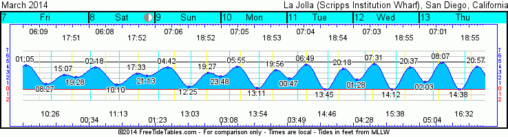
 Tides for La Jolla (Scripps Institution Wharf) starting with March 7, 2014.

www.saltwatertides.com
Day        High      Tide  Height   Sunrise    Moon  Time      % Moon
           /Low      Time    Feet    Sunset                    Visible
 
F    7     High   1:04 AM     4.4   6:09 AM    Rise 10:25 AM      33
     7      Low   8:27 AM     1.0   5:51 PM
     7     High   3:09 PM     2.7
     7      Low   7:28 PM     2.3
 
Sa   8     High   2:17 AM     4.1   6:08 AM     Set 12:34 AM      43
     8      Low  10:09 AM     0.9   5:52 PM    Rise 11:13 AM
     8     High   5:31 PM     2.9
     8      Low   9:15 PM     2.5
 
Su   9     High   4:43 AM     4.0   7:07 AM     Set  1:23 AM      52
     9      Low  12:24 PM     0.6   6:52 PM    Rise  1:02 PM
     9     High   7:26 PM     3.2
     9      Low  11:50 PM     2.4
 
M   10     High   5:56 AM     4.2   7:05 AM     Set  3:08 AM      62
    10      Low   1:12 PM     0.4   6:53 PM    Rise  1:53 PM
    10     High   7:55 PM     3.5
 
Tu  11      Low  12:48 AM     2.0   7:04 AM     Set  3:50 AM      71
    11     High   6:50 AM     4.5   6:54 PM    Rise  2:45 PM
    11      Low   1:45 PM     0.1
    11     High   8:17 PM     3.7
 

Thursday, January 23, 2014

Plenty more good surf on the way!


Oh boy…what a few days it’s been.  Surf is up. Crowds are up…and unfortunately attitudes are up too!  There were a lot of folks jawing for waves out there this week. Hopefully you all had some fun ones!  There’s plenty more where that came from!  Friday morning we’re looking at slightly smaller surf to star the day.  By small I chest to shoulder high through the morning.  Buoy reading show that we should see some VERY INCONSISTENT bigger sets in the morning but the real stuff will pick up later in the afternoon.  By sunset we’ll see waves in the HH to OH+ with the bigger waves in the southern half of the county and at the winter wave magnet spots.  Saturday morning we’re going to wake up to some OH to OH++ around most of San Diego.  Expect some DOH sets at the best winter breaks. The swell peaks mid-morning and then tapers off to HH/OH by nightfall but still packing a punch.  The jet stream whisks that storm to the north pretty quickly so size will back down Sunday.  Look for the HH/OH first thing in the morning with some decent consistency and shoulder/HH with HH+ sets by nightfall. 

There’s another smaller WNW swell for Monday.  Waves start in the shoulder/HH range and then the swell starts to fill in mid-morning.  Swell peaks midday with HH+ sets and with lots of west in this swell most of SD County will see plenty of fun surf all day.  Size backs off Tuesday morning with shoulder/chest high surf for most of the day.  The next WNW fills in right after that for Wednesday with waves bumping back up into the HH/slightly OH range by midday as that swell peaks and then backs off again.  Not a lot of major activity in the northern hemi after that.  A few smaller storms but definitely much calmer than this week. 

We’re looking at some pretty dense morning fog for the next two mornings and slightly cooler air temps in the high 60s/low 70s along the coast.  A bit more clearing for the weekend with air temps in the low 70s but warming up into the high 70s and sunny by Tuesday thru Thursday.  Friday looks pretty cloudy with a wee chance of moisture but I wouldn’t put money on it!  Evening winds look light for the next few nights with E winds on tap for Friday and then some slightly more typical light to moderate NW winds for the weekend and the start of the work week.  Water temps are looking about average or even a bit on the warm side for late Jan…high 50s/60.  Tides are starting to swing a bit more as we approach next week’s new moon.  Not much movement Friday but the late morning low gives way to a very early morning high and near negative to negative midday lows through the weekend and into next week.  The draining out morning and sunset medium high tide push will help that incoming swell on Fri PM and Sat AM.

Looks like plenty more swell!  Play nicely out there and stay wet San Diego!

Lates,
Mish

Ocean Notes:

1)      Friday the Body Glove Maverick's Invitational is ON!!!  The big waves and great conditions should make for some outstanding competition! Watch it live!

2)    You have to see some of the big waves coming through Hawaii the past few days.  It’s just amazing what these guys put their bodies through!  Laird was out towing Peahi and took a digger…I mean, a REALLY BIG DIGGER!

3)    Don’t count CA out of the big wave picture!  With near perfect conditions and plenty of sunshine the photogs were almost as happy as the surfers up and down the coast!


January 21, 2014 Secret Spot
Photo: Mishfish Photos (that's me!)

Tides for La Jolla (Scripps Institution Wharf) starting with January 24, 2014.

www.saltwatertides.
Day        High      Tide  Height   Sunrise    Moon  Time      % Moon
           /Low      Time    Feet    Sunset                    Visible
 
F   24     High   2:45 AM     4.4   6:49 AM    Rise 12:25 AM      54
    24      Low  10:04 AM     1.3   5:14 PM     Set 11:33 AM
    24     High   3:56 PM     2.7
    24      Low   8:39 PM     1.9
 
Sa  25     High   3:52 AM     4.8   6:48 AM    Rise  1:26 AM      43
    25      Low  11:17 AM     0.6   5:15 PM     Set 12:19 PM
    25     High   5:33 PM     2.9
    25      Low  10:05 PM     2.0
 
Su  26     High   4:54 AM     5.2   6:48 AM    Rise  2:29 AM      32
    26      Low  12:11 PM    -0.2   5:16 PM     Set  1:11 PM
    26     High   6:36 PM     3.2
    26      Low  11:16 PM     1.9
 
M   27     High   5:49 AM     5.8   6:47 AM    Rise  3:31 AM      22
    27      Low  12:57 PM    -0.9   5:17 PM     Set  2:10 PM
    27     High   7:22 PM     3.7
 
Tu  28      Low  12:15 AM     1.6   6:46 AM    Rise  4:31 AM      13
    28     High   6:39 AM     6.3   5:18 PM     Set  3:15 PM
    28      Low   1:40 PM    -1.4
    28     High   8:03 PM     4.0
 

Thursday, October 11, 2012

Weather and WNW swell to end the week


(I'm heading out of town from Oct. 11-16th so I'll be back bloggin' next Wed...unless I decide to post from the beach on my vacation...)
 
All sorts of activity going on as we swing from Summer to Fall and back again.  After a few nice SW swells it looks like Mother Nature is tossing us another small WNW groundswell.  You might have heard about the North Shores of the Hawaiian Islands the past few days (see Ocean Notes)…it was CRAN-KING!  The swell isn’t really directed at us but we’re still going to benefit from the leftovers.  We’re already seeing the buoys increasing.  Surf should pick up to waist/chest high for Thursday morning with some slightly better waves at the winter North facing beaches but expect some unfavorable weather to put a bit of bump overnight on the surface.  The swell will hold up through Fri, Sat and Sun with surf in the chest/shoulder range.  Weather and wind will be the biggest factor Fri and Sat. By Sun things should clean up and surf looks pretty nice.  The swell fades Monday with a little pick-me-up from some small SW. Surf in the waist/chest range but slightly better at summer beaches.  That’ll be a short and small swell but we’re expecting another medium NW groundswell for Tues of next week with size at west and north facing beaches back into the waist/chest range with some fun shoulder high sets.  Swell holds for Wed as the swell peaks with some nice chest/shoulder high surf.  Kinda quiet after that with what looks like some smaller NW and a small late SW swell developing. 

We’ve got our first weather maker coming to town tonight with moderate S winds tonight making things a little lumpy in the morning and for most of the day.   Looks like a nice window of light winds in the early hours of the day before winds pickup more out of the S.  Sustaining S winds for most of Thurs night and through Fri and pretty gusty for Sat.  And then we have the rain.  The latest models are actually looking more favorable with about a 0.25” along the coast for the day starting overnight and kind of just drizzling all day.  Definiletly some colder air temps (mid-60s) than we’ve had lately and snow…yes, snow levels to 7000’.  Showers should taper off by Friday dawn with some left over clouds  but then  expect sunshine for the windy Sat and a pretty gorgeous day Sunday and air temps back into the mid 70s.  Big high pressure brings sunshine and high 70s back to town for the first half of the week.  Still some cooler nights though to remind you that it’s Fall.  Some big tide swings as we approach Monday’s New Moon.  Look for fuller morning highs to slow things down a bit and negative lows to really drain out the beach breaks by Sunday.  Water temps still in the low 70s/high 60s.  Expect that to cool down with the NW swells that are moving in.  Yup, time for a full suit!

Looking like some fun surf if you can find a nice window between wind and rain but better conditions for the second half of the weekend.  Surf Sunday…Charger’s aren’t on til Monday!

I’m outta here for warm water, fun waves and a mai tai or two!

Alooooooooooooha!
Mish

Ocean Notes:

1)       One word: PEAHI! (translation: JAWS!)  This is some of the most gorgeous and perfect HUGE surf I've ever seen!  The video will leave you in awe!  Watch Shane Dorian rock the house with a mammoth sized barrel yesterday.

2)      With the rainy season upon I’ll remind everyone not to surf in poo!  This storm will be the FIRST FLUSH.  Yes, it’s as bad as it sounds.  Check out Coast Keeper’s County Beach Status website.  And watch the water around Ponto.  9000 gallons of sewage spilled there two days ago…POOPY WATER!!!!!!!!! That’s just gonna get flushed out even more as it rains.  Be mindful!

3)      The newest high profile surf flick to hit the theaters later this month is getting some pretty good reviews. Check out the trailer for Chasing Mavericks , the story of Jay Moriarty and his passion for a well know deadly surf spot.

4)      And to end the Ocean Notes let’s just take a nice look back at some fun clean California October sessions.


Tides for La Jolla (Scripps Institution Wharf) starting with October 11, 2012.

www.saltwatertiedes.com
Day        High      Tide  Height   Sunrise    Moon  Time      % Moon
           /Low      Time    Feet    Sunset                    Visible
 
Th  11      Low  12:44 AM     0.6   6:51 AM    Rise  2:46 AM      25
    11     High   7:16 AM     4.7   6:20 PM     Set  3:49 PM
    11      Low   1:03 PM     1.6
    11     High   7:02 PM     4.9
 
F   12      Low   1:18 AM     0.5   6:52 AM    Rise  3:48 AM      16
    12     High   7:42 AM     5.2   6:19 PM     Set  4:25 PM
    12      Low   1:43 PM     0.9
    12     High   7:47 PM     5.1
 
Sa  13      Low   1:50 AM     0.5   6:52 AM    Rise  4:52 AM      9
    13     High   8:10 AM     5.6   6:18 PM     Set  5:01 PM
    13      Low   2:24 PM     0.2
    13     High   8:32 PM     5.2
 
Su  14      Low   2:23 AM     0.6   6:53 AM    Rise  5:58 AM      3
    14     High   8:41 AM     6.1   6:17 PM     Set  5:40 PM
    14      Low   3:05 PM    -0.3
    14     High   9:17 PM     5.1
 
M   15      Low   2:57 AM     0.8   6:54 AM    Rise  7:06 AM      0
    15     High   9:14 AM     6.4   6:15 PM     Set  6:23 PM
    15      Low   3:49 PM    -0.7
    15     High  10:04 PM     4.9
 
Tu  16      Low   3:32 AM     1.1   6:55 AM    Rise  8:16 AM      0
    16     High   9:51 AM     6.5   6:14 PM     Set  7:10 PM
    16      Low   4:36 PM    -0.9
    16     High  10:54 PM     4.5
 
W   17      Low   4:09 AM     1.4   6:55 AM    Rise  9:25 AM      2
    17     High  10:30 AM     6.5   6:13 PM     Set  8:03 PM
    17      Low   5:26 PM    -0.8
    17     High  11:50 PM     4.1
