Showing posts with label SDGE. Show all posts

Thursday, October 4, 2012

Fading steep SW, smaller SW and NW on tap


Aloha!  Some fading steeper SW swell for the Friday session in the waist high range at most spots but some chest high waves at the better summer spots.  Swell fades even more Sat with some NW wind swell on top of the small fading S.  A bit of low pressure will make it down our way on Monday bringing more NW wind swell with some background small S. Waves in the waist/chest high range but a little messy I’m thinking with the wind swell dominating. Mostly NW wind swell in the waist high range for Tues and Wed. South Pacific is showing signs of some groundswell development but we don’t see it for at least a week or so.  The big story is the NW ground swell that looks to show up around Thurs/Fri. Looks like some good energy with plenty of west in it to make for some fun sessions throughout SoCal!

Weather is definitely turning towards Fall as temperatures start to cool down into the low 70s along the coast, some moderate morning and late evening marine layer and cooler nighttime sleeping temps in the mid to low 60s.  We should still see sunshine midday though.  There’s a slight chance of drizzle late Monday and into Tuesday.  Calm morning breeze turning E early and then SW by the afternoon.  This will definitely put some bump on most spots mixing with that NW wind swell.  More westerly winds by Monday.  Water temps are in the high 60s/low 70s with the southern half of the county seeing the colder end of the spectrum.  Tides aren’t doing much through the weekend with little or no movement as we’re mid-moon cycle. 

Still looks like some fun but smaller surf out there.  Definitely have to pick your spots a little better but water’s still pretty warm and the sun’s still shining!

Get wet!
Mish

Ocean Notes:

1)       The big event is HERE this weekend!  From the creator of Sacred Craft it’s The Boardroom!  Saturday and Sunday at the Del Mar Fairgrounds is everything you ever needed to know or see that’s related to surfboards!  This year’s show is a tribute to the legendary Mark Richards. There’s everything from surfboard shaping legends, new school shapers, live shaping demos, auctions, movies, and food!  On Sunday morning at Power House park in Del Mar you can even demo boards, wetsuits and fins from 7am –noon.  This is THE place to be this weekend!

2)      If you’re interested in putting solar in your house why not check out SDG&E’s free seminars later this month.  There’s one for solar water heaters and another for solar systems in general.  They’re continually rolling out helpful seminars for home and businesses.  And, uh…FREE!

3)      With the spooky Halloweek season upon us I can’t help but mention some of the fun events around town.  If you don’t already know about the Bates Nut Farm then you’re missing out!  This place is Halloween and Fall celebration in…well, a nutshell! Pumpkins from 40-200lbs are just the start.  Check out their link for more info on all their fun events!

4)      And now for something a little more surfy surfy!  The Quicksilver Pro is going OFF in France right now with insane waves being ridden by the world’s best.  You know who I’m talking about…THE BEST in awesome waves.  Check out the pics from Day Four.  Sweetness!

5)      And I will end with this beautiful composite of gorgeous waves from around our planet this past September.  We need to keep our planet healthy and our oceans clean so we can continue to enjoy waves like this.  (sigh)


One from the archives...
 

Tides for La Jolla (Scripps Institution Wharf) starting with October 5, 2012.

www.saltwatertides.com
Day        High      Tide  Height   Sunrise    Moon  Time      % Moon
           /Low      Time    Feet    Sunset                    Visible
 
F    5     High   1:13 AM     3.2   6:47 AM     Set 11:43 AM      80
     5      Low   5:25 AM     2.7   6:28 PM    Rise 10:10 PM
     5     High  12:05 PM     4.8
     5      Low   7:41 PM     1.2
 
Sa   6     High   2:43 AM     3.0   6:47 AM     Set 12:31 PM      72
     6      Low   5:42 AM     3.0   6:27 PM    Rise 11:00 PM
     6     High  12:53 PM     4.5
     6      Low   8:59 PM     1.3
 
Su   7     High   2:17 PM     4.2   6:48 AM     Set  1:15 PM      63
     7      Low  10:21 PM     1.3   6:25 PM    Rise 11:53 PM
 
M    8     High   6:17 AM     3.5   6:49 AM     Set  1:57 PM      54
     8      Low  10:09 AM     3.3   6:24 PM
     8     High   3:57 PM     4.1
     8      Low  11:23 PM     1.1
 
Tu   9     High   6:33 AM     3.9   6:49 AM    Rise 12:49 AM      44
     9      Low  11:29 AM     2.8   6:23 PM     Set  2:36 PM
     9     High   5:14 PM     4.3

Sunday, August 19, 2012

Last of the SW for a while...


Holy melting surf wax Batman!  The good news is this heat is supposed to break this week (yeh, I know…we really shouldn’t complain) but the bad news is that there’s not much swell going on after Wed.  Today we actually saw some fun SW swell. Monday we’re looking at more leftovers in the waist/chest high range out of the S with some NW wind swell lumped on top.  Tuesday is looking smaller with mostly waist high SW and a bit more wind swell and  Wednesday is looking yet smaller with waist high topping off the better sets.  Thursday look for knee high surf with some very steep SE swell hitting the buoys but missing most of SD County.  This will be another swell to head to OC or LA for with only a few stragglers making it into our swell window for the occasional waist high wave.  Same story for Friday, Saturday and Sunday.  We’ll see some smaller wind swell on top of the near non-existent SE swell but surf will remain in the knee high range with the rare waist high wave. I’m not seeing any big swell makers in either hemisphere.  Storms are sliding off the ice shelf a little too close to Chile to be much use to us and the N. Pac has a few little squeakers that might actually throw more NW at us (El Nino?) in the upcoming weeks.

As I mentioned at the top of the forecast it looks like things might cool down a bit more this week.  Monday and Tuesday look to be warm and sunny again (high 70s along the coast) but then cooling to the mid70s and even low 70s by the end of the week and into next weekend.  We should also have some cooler nights which will make for better sleeping conditions.  Calm mornings with light to moderate SW winds for the afternoon.  The way the moisture is moving around we’re still going to see a lot of humidity so the beach will still be the place to be to cool things off.  That being said the water temps are a warm 72 degrees around town.  As we come off the New Moon last Friday there’s a low tide for the dawn patrol with a moderate high midday and then another decent low a few hours before sunset.  That should help things out with a little tide push for the sunset session.

Hope you all got some fun surf this weekend.  If you or little ones are heading back to school this week farewell to summer…but remember, we do live in Southern California…land of the Endless Summer (well, until El Nino hits!).

Have a great week everyone and please don’t forget to lather on that SPF!

Mish

Ocean Notes:

1)       With all of this sunshine just blazing away and electricity bills soaring sky high perhaps more of you are thinking of going solar. SDG&E is here to help with their FREE Solar for Homeowners - Getting Started seminar.  Why waste a good thing?

2)       And if you don’t already have it on your phone it’s time to download (or update) the Monterey Bay Aquarium Seafood Watch App.  It’s got up-to-date recommendations for ocean friendly seafood and now has locations of markets and restaurants where you can find sustainable seafood.

3)      While things aren’t exactly pumping down in Tahiti the pros still make it look better than a day in my office at the Billabong Pro Tahiti. How does it compare to yours?

4)      In the upcoming months San Diego Association of Governments (SANDAG) will be replenishing the sand at local beaches.  They will start moving equipment at IB this week, start moving sand the start of Sept and then work on North County beaches from early Oct to late November.  For more information and updates check out their beach sand replenishment website. 

5)      And we’ll end on a nice surfy surfy note… Bali surf on YouTube!  


Tides for La Jolla (Scripps Institution Wharf) starting with August 20, 2012.

Day        High      Tide  Height   Sunrise    Moon  Time      % Moon
           /Low      Time    Feet    Sunset                    Visible
 
M   20      Low   5:14 AM     0.3   6:16 AM    Rise  9:28 AM      5
    20     High  11:38 AM     5.3   7:28 PM     Set  9:11 PM
    20      Low   5:45 PM     0.9
    20     High  11:47 PM     4.7
 
Tu  21      Low   5:46 AM     0.8   6:17 AM    Rise 10:33 AM      12
    21     High  12:16 PM     5.3   7:27 PM     Set  9:51 PM
    21      Low   6:43 PM     1.0
 
W   22     High  12:42 AM     4.0   6:18 AM    Rise 11:39 AM      20
    22      Low   6:22 AM     1.4   7:26 PM     Set 10:34 PM
    22     High   1:02 PM     5.3
    22      Low   7:54 PM     1.0
 
Th  23     High   1:56 AM     3.4   6:18 AM    Rise 12:45 PM      30
    23      Low   7:05 AM     1.9   7:24 PM     Set 11:23 PM
    23     High   2:01 PM     5.2
    23      Low   9:23 PM     1.0
 
F   24     High   3:42 AM     3.0   6:19 AM    Rise  1:49 PM      41
    24      Low   8:10 AM     2.4   7:23 PM
    24     High   3:17 PM     5.2
    24      Low  10:57 PM     0.7

Wednesday, August 8, 2012

Some fun warm S swells on the way!


Is it just me or is it hot in here?  Hot and steamy…too bad we’re not all on vacation in some super tropical location!  Well, at least we have some surf.  We’ve been seeing some really steep SSE swell that’s been missing a lot of SD with the NW wind swell filling in for some waist high waves.  Spots up in north N. County have been seeing some shoulder/HH+ sets but that’s backing off to waist/chest for Thursday.  Look for waist high again at most SD beaches.  Late Thursday a new SW will be filling in for Friday morning.  Surf should bump back up into the waist/chest range for more of SD County as there’s more W in this SW.  The energy is much lower than this last swell but directed much better into our swell window.  Things back off a little Saturday but then Sunday afternoon we should see more SW swell and things hitting the chest/shoulder range for the summer south spots.  The icing on this cake is Hurricane Gilma.  While not the biggest baddest hurricane in town (in fact she doesn’t really hit hurricane status until Thursday) she’s turning a little more northerly which is good news if she continues to head our direction.  That swell will show up Monday/Tues with some fun energetic swell in the chest/shoulder high range with some larger HH sets (as long as she stays heading N).  And there’s more swell on the way too for the end of the week…looks promising!

So this heat wave that we’re having is going to stick around for a few more days, through the weekend and actually into next week!  Things will cool down a tad…from the low 80s to the high 70s by Monday along the coast.  Winds look nominal too…a welcome breeze to cool us off in the afternoon.  Very slight breeze out of the S for the AM and turning more SW by midday.  Temps remain warm through the night…high 60s.  UGH!  The best news is the water is in the low 70s throughout SD County with warmer water sitting offshore. Hopefully these next few swells will push that warmer water even farther north.  Tides aren’t really doing much over the next few days…in fact, practically nothing at all on Friday morning with a 0.1’ tide “swing” from high to low then a bit more water movement n the afternoon. 

Looks like some fun surf on it’s way…warm water…sunny skies…yup, we’re living the life folks.  Appreciate it!

Lates,
Mish

Ocean Notes:

1)       With the super hot weather in town for awhile SDG&E has declared a “Reduce Your Use” day tomorrow. This means we need to try extra hard to turn off electrical appliance during peak hours (11am-6pm).  This includes unplugging things that actually use energy even though they’re turned “off” like TVs, DVDs, computers, entertainment systems and phone and battery chargers.  You can even sign up and they’ll send you a notice letting you know when “Reduce Your Use” days are coming.  You can even get rewards on your SDG&E bill! Click HERE for more info.

2)       If you haven’t already cleaned out your closets this past Spring and have a house full of “STUFF” then you definitely need to watch this short 20 minute flick called, "The Story of Stuff".   It chronicles (in only 20 minutes) the story of production to destruction of all of our “stuff”.  A great flick and much see TV!

3)      And my most favorite challenge I’ve seen in a long time…the "Tape It, Don't Trash It: Duct Tape Challenge".  What have you done with duct tape to extend the life of something precious to you?  Lowes wants to know!  Love it!

4)      Something’s brewing between Surfrider and Stone Brewing …come find out what it is on Friday and Saturday at Cal State San Marcos. That is only if you like tasty craft beer of course!  Proceeds head on over to SD Surfrider!

5)      And now for something surfy…Teahupoo and a HUGE spitter.  SWEET!

6)      And more Teahupoo…but this is Bruce Irons sharing one of his scariest moments…and something tells me he doesn’t have many of those when he’s surfing!

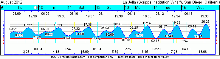
 Tides for La Jolla (Scripps Institution Wharf) starting with August 9, 2012.

www.saltwatertides.com
Day        High      Tide  Height   Sunrise    Moon  Time      % Moon
           /Low      Time    Feet    Sunset                    Visible
 
Th   9     High   3:28 AM     2.9   6:09 AM     Set  1:25 PM      58
     9      Low   8:09 AM     2.4   7:40 PM
     9     High   3:22 PM     4.5
     9      Low  11:13 PM     1.6
 
F   10     High   6:07 AM     2.9   6:09 AM    Rise 12:04 AM      49
    10      Low   9:27 AM     2.8   7:39 PM     Set  2:18 PM
    10     High   4:33 PM     4.6
 
Sa  11      Low  12:28 AM     1.2   6:10 AM    Rise 12:47 AM      39
    11     High   7:32 AM     3.1   7:38 PM     Set  3:10 PM
    11      Low  11:00 AM     2.9
    11     High   5:38 PM     4.8
 
Su  12      Low   1:14 AM     0.8   6:11 AM    Rise  1:34 AM      30
    12     High   8:03 AM     3.4   7:37 PM     Set  3:59 PM
    12      Low  12:09 PM     2.7
    12     High   6:30 PM     5.1
 
M   13      Low   1:48 AM     0.4   6:11 AM    Rise  2:25 AM      22
    13     High   8:25 AM     3.6   7:36 PM     Set  4:45 PM
    13      Low  12:59 PM     2.4
    13     High   7:14 PM     5.4