Sunday, September 23, 2012

More surf...S AND NW...!


Greetings Earthlings!  Looks like we’re coming off some pretty small swell but will start the week of right with some building SW groundswell Monday and our first NW groundswell starting to fill in late Monday and into Tuesday (Just check the Pipeline cams if you don't believe me!).  Surf looks to be only thigh/waist high Monday morning with some slightly bigger waist high surf by the evening out of the NW.  Tuesday morning will see waist high surf building through the day to waist/chest and peaking late in the day with the occasional shoulder high wave at the better N facing winter spots.  I would hardly call it “Opening Day” but it’s definitely the first good NW groundswell that’s popped up from the Aleutians.  Wed things start to back off as we see some background surf from Hurricane Miriam as she heads NW.  This is a very good thing as right now she’s a little too far SE so the swells will start off too steep for most of SD (OC and LA I’m talking to you here!) but if she moves up in the forecasted path then we should see some pretty nice hurricane swell in the chest/shoulder range by Thurs and Fri with swell peaking in the occasional HH range at more of the SD beaches by Sat.  It’ll never be SW mind you so still hit the better summer spots to take advantage of this swell.  The good news is there is another SW ground swell that looks to be heading into our swell window.  This one looks to have some kick in it as the storm that created it is sitting in our window and is just sitting there stirring up swell. Look for surf to bum up next Sunday throughout the county…Saturday afternoon and Sunday.  As the week passes I’ll keep you updated on how that swell is going to show up…don’t want this to just be another “internet hype” swell eh?

The Fall weather is upon us…sort of.  We’re still going to see some pretty nice temperatures in the high 70s along the coast but we’ll also see a bit more onshore west wind midweek as the high pressure system breaks down a little, temperatures cool and the system that created that NW groundswell nudges us a little.  I don’t think we’ll actually see water fall from the sky just yet but we might see a few more clouds for the latter part of the week.  The best part is that we’ll see cooler nighttime temps Mon-Thurs…much more pleasant sleeping weather.   The morning sessions look like they might have a little light offshore for the first few days of the week before the breezes pick up.  Nice!  And as we near the Full Moon on Saturday we’re going to start seeing a bit more water movement throughout the week.  We’ll start with medium high early AM, medium low midday to big high at sunset and then see more extreme movement by Wed.  Water temps are trying to warm up but we’re still seeing the high 60sa and low 70 here and there with slightly warmer temps in N. County in the mid 70s.  I’m hoping this steep hurricane swell combo’d with the NW groundswell doesn’t cool things down too much this week.

Looks like a fun week of surf on into the weekend.  The early and sunset sessions might be your best bet as winds might become an issue midday.  Enjoy it…this is the best part of the year (if you ask me!).

Lates,
Mish

Ocean Notes:

1)       This Wednesday catch Taylor Steele’s This Time Tomorrow at La Paloma Theater at 8pm.  You can’t beat the combo of a Taylor Steele surf flick with Dave Rastovich and Craig Anderson tracking a Pacific swell.  Gonna be some fine surfing!  Catch it!

2)      Here’s a good one…have you been munching on the pricey water-grown veggies from your local farmer’s market?  Well now you can do hydroponic gardening thanks to IKEA!  Yes, just click on the link…you’ll be pleasantly surprised!

3)      Put this on your calendar…the Patagonia store in Cardiff will be having another Board Swap on Sat. October 13th from 8-noon.  Email store_cardiff@patagonia.com to reserve a spot. It’s free to have your boards there and Patagonia doesn’t take a cut.

4)      Yup, Slates sets another record for us to gawk at…50 WCT wins with #50 happening last week at Trestles in some inconsistent and fading S swell but it was enough to get the man his trophy.  Must be nice!

5)      And here’s more eye candy to end these notes…crankin’ Tassie surf…big and cold.  Dang…I mean BIG AND COLD!


Tides for La Jolla (Scripps Institution Wharf) starting with September 24, 2012.

www.saltwatertides.com
Day        High      Tide  Height   Sunrise    Moon  Time      % Moon
           /Low      Time    Feet    Sunset                    Visible
 
M   24     High   6:41 AM     4.0   6:39 AM     Set  1:16 AM      61
    24      Low  11:42 AM     2.5   6:42 PM    Rise  3:18 PM
    24     High   5:47 PM     5.2
 
Tu  25      Low  12:42 AM     0.1   6:40 AM     Set  2:19 AM      72
    25     High   7:20 AM     4.5   6:41 PM    Rise  3:58 PM
    25      Low  12:45 PM     1.9
    25     High   6:48 PM     5.3
 
W   26      Low   1:24 AM     0.0   6:40 AM     Set  3:20 AM      81
    26     High   7:52 AM     4.9   6:40 PM    Rise  4:34 PM
    26      Low   1:34 PM     1.4
    26     High   7:38 PM     5.4
 
Th  27      Low   2:00 AM     0.1   6:41 AM     Set  4:20 AM      88
    27     High   8:21 AM     5.2   6:38 PM    Rise  5:08 PM
    27      Low   2:15 PM     0.9
    27     High   8:22 PM     5.4
 
F   28      Low   2:32 AM     0.2   6:42 AM     Set  5:19 AM      94
    28     High   8:49 AM     5.4   6:37 PM    Rise  5:41 PM
    28      Low   2:53 PM     0.6
    28     High   9:02 PM     5.2
 

Tuesday, September 18, 2012

New swell moving in!


We’re on the up with a new SW swell on it’s way in.  The buoys have picked up and there were even a few early arrivers this evening.  After the last bits of Kristy swell dribbles past SD County look for surf to pick up around town Wednesday into the waist/chest high range with south facing beaches more noticeable of course.  Swell holds in size through the day and into Thursday morning before starting to taper off in the evening.  We’ll also see some NW wind swell mixed in there that will put some excess bump on the SW.  Friday we’re seeing more NW wind swell than SW but surf still in the waist high range.  Saturday things really taper off with knee high surf mostly from the NW wind swell…small still for the start of Sunday.  The good news is that a WSW swell should fill in starting Sun afternoon with a small pick up in size into the waist high range.  Monday and Tuesday will see most waist/chest high surf with the added bonus of…yes, our first NW ground swell!  The storm that is creating this swell is forecasted to just swoop down into our swell window for a short period so most of the swell will be aimed at the Hawaiian Islands earlier in the week before we get it around the middle of next week.  I’ll keep my eyes on that storm and update you in a few days.

More fantastic weather on board with some early morning fog, clearing skies and pleasant air temps in the mid/upper 70s along the coast.  Look for a little warm up for the end of the week and plenty of sunshine for the weekend.  Winds light to calm in the mornings with the usual light to moderate west winds for the afternoon.  Water temps are in the high60s/low 70s with the cooler water being in the lower half of the county.  We’re looking at some decent tide swings as we come off the new moon.  Still a big high just before midday that might give the new swell a nice push before slowing things down.  Then things drain out for the sunset session…could be pretty fun at the right south facing beach.

Looks like some Fall/Winter surf is right around the corner…

We’re overdue!
Mish 

Ocean Notes:
1)       If you’re a beer and bratwurst kinda guy or gal then get thyself to Encinitas this Sunday for the Oktoberfest celebration!  For more info click here!

2)      Goofy footer’s delight…some sweet footage of Craig Anderson from Daily Surf Videos.

3)      Hurricane Kristy helped out with some surf for Trestles just in time for the Hurley Pro this week.  And you have to love the free surf sessions.  Pros just ripping it up and having fun…just like you and I right?

4)      A horrendous oil spill down in Mainland Mex in the Oxaca region is now coating beaches over 120 miles of coastline.  Not only did the 4750 galls of oil go uncontained but you can imagine the havoc it’s wreaking on the marine life.  Read this Surfer Mag article for more of the ugly details.

5)      Here are some waves to really drool over…the Put Up or Shut Up  freesurfing tournament at G-land…come on…you know this has to be good!


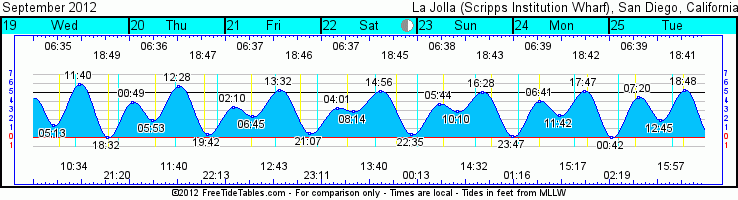
Tides for La Jolla (Scripps Institution Wharf) starting with September 19, 2012.

www.saltwatertides.com
Day        High      Tide  Height   Sunrise    Moon  Time      % Moon
           /Low      Time    Feet    Sunset                    Visible
 
W   19      Low   5:13 AM     1.4   6:36 AM    Rise 10:34 AM      10
    19     High  11:40 AM     5.9   6:49 PM     Set  9:20 PM
    19      Low   6:32 PM     0.1
 
Th  20     High  12:49 AM     3.9   6:36 AM    Rise 11:41 AM      18
    20      Low   5:53 AM     1.9   6:48 PM     Set 10:13 PM
    20     High  12:28 PM     5.7
    20      Low   7:42 PM     0.4
 
F   21     High   2:10 AM     3.4   6:37 AM    Rise 12:43 PM      28
    21      Low   6:45 AM     2.4   6:46 PM     Set 11:11 PM
    21     High   1:32 PM     5.3
    21      Low   9:07 PM     0.5
 
Sa  22     High   4:01 AM     3.3   6:38 AM    Rise  1:41 PM      39
    22      Low   8:14 AM     2.9   6:45 PM
    22     High   2:56 PM     5.1
    22      Low  10:35 PM     0.4
 
Su  23     High   5:44 AM     3.7   6:38 AM     Set 12:13 AM      50
    23      Low  10:10 AM     2.9   6:44 PM    Rise  2:32 PM
    23     High   4:28 PM     5.1
    23      Low  11:47 PM     0.2

Saturday, September 15, 2012

Hot small tropical storm surf then some groundswell


Seeing a little love out of the SSE from Tropical Storm Kristy this afternoon so if you hit the right south facing beach (mostly waaaaaaay up north county) you can still score some waves for Sunday. Look for some decent chest/shoulder high waves at the best summer spots up north. Around the rest of SD we’re looking at more small NW wind swell in the waist high range and very little gusto.  Look for things taper off Monday and then midday Tuesday we should see our next SW swell and surf will bump back up into the waist/chest range.  There’s a slightly better angle on this one…slightly so more of SD county will see some surf.  Swell builds slightly through Wed with mostly chest high surf before tapering off Thurs and Fri with waist high waves.  Looks like we should see some more swell developing for next weekend with some activity down by New Zealand but it’s got some time to get here so we’ll wait and see what it does.  We also have Tropical Storm Lane stirring around down there but he’s looking pretty weak and not quite headed in our direction…you never know!

The weather is…um, HOT!  SO HOT!  (“HOW HOT IS IT???”  It was so hot on the coast today the sea gulls were flying to Death Valley to cool off!  Dah dun dun!)  Slightly less heat for the rest of the weekend and next week...still plenty of heat but more tolerable (we’re such woosies in the SoCal) in the mid/low 80s instead of 100s!  Sunny skies and a SE little breeze to start the day with a SW breeze for Sunday and most westerly by midday Monday.  Low humidity makes it a dryyyyyyyyyyy heat and nighttime temps are in the mid65s.  Some bigger tide swings with the new moon Sunday.  Looking at a high tide mid-morning draining out to a late-afternoon super low tide and swinging back up high as the sun sets.  Water temps have cooled a  bit but you’d never know it with the high heat lately.  Mid to high 60s in the water but some warmer temps offshore so with a little SW swell things should heat back up.  Enjoy it during this heat wave!

That’s all she wrote folks…still a little bug keeping me down so no Ocean Notes today.

Adios!
Mish


Tides for La Jolla (Scripps Institution Wharf) starting with September 16, 2012.

www.saltewatertides.com
 
Day        High      Tide  Height   Sunrise    Moon  Time      % Moon
           /Low      Time    Feet    Sunset                    Visible
 
Su  16      Low   3:34 AM     0.2   6:34 AM    Rise  7:13 AM      0
    16     High   9:50 AM     5.7   6:53 PM     Set  7:08 PM
    16      Low   4:00 PM     0.1
    16     High  10:10 PM     5.4
 
M   17      Low   4:06 AM     0.5   6:34 AM    Rise  8:19 AM      0
    17     High  10:23 AM     5.9   6:52 PM     Set  7:48 PM
    17      Low   4:45 PM     0.0
    17     High  10:56 PM     5.0
 
Tu  18      Low   4:38 AM     0.9   6:35 AM    Rise  9:27 AM      4
    18     High  10:59 AM     6.0   6:51 PM     Set  8:32 PM
    18      Low   5:35 PM     0.0
    18     High  11:47 PM     4.4
 
W   19      Low   5:13 AM     1.4   6:36 AM    Rise 10:34 AM      10
    19     High  11:40 AM     5.9   6:49 PM     Set  9:20 PM
    19      Low   6:32 PM     0.1
 
Th  20     High  12:49 AM     3.9   6:36 AM    Rise 11:41 AM      18
    20      Low   5:53 AM     1.9   6:48 PM     Set 10:13 PM
    20     High  12:28 PM     5.7
    20      Low   7:42 PM     0.4

Monday, September 10, 2012

Pretty small with some S by Thursday

(For those of you on my email list I can't figure out why it's not sending the blogs to your email...still working on it...thanks for following!)


Aloha!  Fighting the flu so this is gonna be quick.  Not much on tap for the next 48hrs.  Tues and Wed look pretty quiet with little to no swell.  By Thursday we should see a little bump up of waist/chest high surf by midday. The angle doesn’t have as much west as I’d like for most of SD to get waves but we should still see some surf around town.  Continuing S swell for Friday mixed in with some NW windswell giving us surf in the waist high range.  Size drops off for Sat with some knee/waist surf.  Sunday will see more windswell and a new but poorly angled SE swell.  I’m pretty sure this one will miss SD so look for small surf for the start of next week.

Weather wise we’re looking at continuing heat, sunshine, and a little morning fog.  Light winds and medium water movement for the first half of the week with much more extreme water movement for the second half of the week as we approach the New Moon on Sunday.  Water’s back up to the low 70s thank goodness. 

Some good paddling water out there…keep those arms in shape…Winter’s right around the corner!

Mish

Sorry, no Ocean Notes today!

Mish


Tides for La Jolla (Scripps Institution Wharf) starting with September 10, 2012.

www.freesaltwatertides.com 
 
Day        High      Tide  Height   Sunrise    Moon  Time      % Moon
           /Low      Time    Feet    Sunset                    Visible
 
M   10      Low  12:27 AM     1.0   6:30 AM    Rise  1:09 AM      37
    10     High   7:27 AM     3.6   7:01 PM     Set  3:22 PM
    10      Low  11:53 AM     2.8
    10     High   5:58 PM     4.8
 
Tu  11      Low   1:05 AM     0.6   6:31 AM    Rise  2:04 AM      28
    11     High   7:44 AM     4.0   7:00 PM     Set  4:03 PM
    11      Low  12:43 PM     2.4
    11     High   6:46 PM     5.2
 
W   12      Low   1:36 AM     0.3   6:31 AM    Rise  3:02 AM      19
    12     High   8:04 AM     4.2   6:59 PM     Set  4:42 PM
    12      Low   1:23 PM     1.9
    12     High   7:28 PM     5.4
 
Th  13      Low   2:05 AM     0.1   6:32 AM    Rise  4:02 AM      12
    13     High   8:27 AM     4.7   6:57 PM     Set  5:19 PM
    13      Low   2:01 PM     1.4
    13     High   8:08 PM     5.6
 
F   14      Low   2:35 AM     0.0   6:33 AM    Rise  5:04 AM      6
    14     High   8:53 AM     5.1   6:56 PM     Set  5:55 PM
    14      Low   2:39 PM     0.9
    14     High   8:47 PM     5.7

Thursday, September 6, 2012

Pretty small for SD...some S up north.


Hola campers!  Hope the short work week is treating everyone well.  We’re on the tail end of this latest SSW swell with most of SD in the knee high range for Friday but spots around O’side and north will still be seeing some waist/chest high surf.  (Hope you checked out yesterday’s quick post for pics…sick!)  Things get pretty small for Saturday and Sunday as that SSW poops out and nothing much fills the void.  Late Sun and into Monday it looks like a small NW will actually show up and surf should bump up at the more westerly and northerly breaks in the waist high range.  About the same for Tuesday and smaller for Wednesday.   We’ll see some steep and small background S swell at the same time but like this last swell SD will be left out and any lingering energy will head north to OC and LA. A SW groundswell looks to fill in for the end of next week and into the weekend.  This swell has some energy but got stuck behind New Zealand and redirected so most of the energy isn’t heading our way but we should still see some fun waist/chest surf for midday Thursday and into Friday and the weekend. 

The heat isn’t letting up much for the weekend with daily highs dipping a few degrees but the humidity and mild winds will continue thru the weekend.  More patchy early morning fog clearing to sunny skies by mid morning.  The humidity should taper off a little next week but the heat will remain.  Tides aren’t much  with a little movement through the middle of the day but no swell for it to help out.  Water temp seems to be the biggest  news maker around these parts with some pretty brisk temperatures showing up.  Those S and SE swells pushed the water north and offshore causing for some upwelling which is great for the kelp but means some chilly water temps in the mid to even low 60s in some spots.  COOOOOOOOOLD!  The midday sun helps for sure but just be prepared.  The satellite images show some warmer water moving back in so things should start warming up again but there might definitely be some cooler spots for a few days especially at the lower tides.

Well, looks like SUP sales will be on the rise for a few days as the doldrums continue in SD County.  Folks up north are still grinning from ear to ear (just wait for Winter El Nino swell!).

Get wet San Diego!
Mish

Ocean Notes:

1)       The Indian Ocean is set to rock the house and Reunion Island has been having a heck of a summer.  The Fall should be just as good…if not better!  Check out some pumping swell on Surfline.

2)      And if you’re heading to Indo soon, well, you lucky dog you! 


3)      And if you’re ready for big cold surf check out this Surfline article…big, gorgeous, clean but COOOOOOOLD (and sharky) Southern Oz.  Awesome!

4)      Does it ever end?  More sick coverage of the latest swell.  

5)      And more…we can’t forget Trestles !  Can we?


Tides for La Jolla (Scripps Institution Wharf) starting with September 7, 2012.

Day        High      Tide  Height   Sunrise    Moon  Time      % Moon
           /Low      Time    Feet    Sunset                    Visible
 
F    7     High   3:02 AM     2.9   6:28 AM     Set  1:01 PM      65
     7      Low   6:37 AM     2.8   7:05 PM    Rise 11:28 PM
     7     High   2:04 PM     4.4
     7      Low  10:06 PM     1.6
 
Sa   8     High   3:31 PM     4.3   6:29 AM     Set  1:51 PM      56
     8      Low  11:34 PM     1.4   7:04 PM
 
Su   9     High   7:13 AM     3.3   6:29 AM    Rise 12:16 AM      47
     9      Low  10:39 AM     3.2   7:03 PM     Set  2:38 PM
     9     High   4:55 PM     4.5
 
M   10      Low  12:27 AM     1.0   6:30 AM    Rise  1:09 AM      37
    10     High   7:27 AM     3.6   7:01 PM     Set  3:22 PM
    10      Low  11:53 AM     2.8
    10     High   5:58 PM     4.8
 
Tu  11      Low   1:05 AM     0.6   6:31 AM    Rise  2:04 AM      28
    11     High   7:44 AM     4.0   7:00 PM     Set  4:03 PM
    11      Low  12:43 PM     2.4
    11     High   6:46 PM     5.2

Wednesday, September 5, 2012

Labor Day Weekend surf pics...


Just had to share this link from Surfline…some insane pics from this weekend's swell.

Full forecast tomorrow…it’ll be F-L-A-T tomorrow…picking up a hair on Friday.

Mish

Monday, September 3, 2012

Happy Labor Day surf!


Ahhhhhhhhhh, let the summer truly begin!  The lineups will (hopefully) be a little less packed and the roads will have a few less cars on them after today.   Bring on the SUMMER SWELLS!  I hope everyone got in the water.  Unless you headed to far North County it was a bit jumbled as we had both S swell (steeper than I had originally anticipated) and hurricane swell.  It was also significantly smaller.  Some good summer spots were picking up the energy but it was messy and not all that big while other breaks up north were cranking and punishing to those of us with “small swell noodle arms”.  Things should calm down a bit more Tuesday and become more consistent with waist/chest high surf around most of SD County and still some chest/shoulder high surf at the northerly reaches of town.  That S and the hurricane swell will continue to taper off through the day and will be around but still smaller for Wed.  Thursday looks to be the smallest day of the week with steep Tropical Storm John swell flying by us.  Winds aren’t very impressive for John and the direction will be mostly out of SD’s window but it is forecasted to turn north so we might get a little nugget or two Thursday. Friday we’re looking for a new and smaller short-lived SW swell.  This will have a similar angle as the one we’re having now so not ideal for all of SD but the best summer spots will see surf pick up into the waist and occasional chest high range.   Saturday will see smaller surf with some energy in the waist high range.  Sunday is looking like…dare I say it…some WNW swell?  A doozy of a storm peeked into the N. Pac and threw a shot of swell our way.  It’s not huge groundswell by any means but perhaps a hint of some swell by next Sun/Mon.  Looks like a little activity in the S. Pacific might throw us some love for the middle/end of next week.  The N. Pacific goes quiet again but there’s still plenty of time for activity up there this winter (Come on El Nino!).

Same old boring weather for the upcoming week.  Some dense morning fog as the water temps have dipped a little and it’s still scorching inland.  Things should clear up by late morning with some light/moderate west winds kicking up in the afternoon.  Same story for the rest of the week with a little less fog and hopefully more sunshine.  Air temps in the high to mid 70s.  Water temps have dipped a little so we’re seeing 69-71 around town.  The tides are already mellowing out from Friday’s Blue Moon so we’re seeing a medium low a little before dawn pushing to a medium high midday and then dropping out another medium low at sunset.

Hope everyone had a few fun waves, good times with friends and family and some tasty BBQ!  Happy Labor Day!

Alooooooha!
Mish

Ocean Notes:

1)       With the fun surf we’ve had this wave pool might look boring but these guys are pretty good and make it look easy.  Go ahead…give it a whirl! 

2)      If you’re heading to the south end of the county for a surf you might want to check Coastkeeper’s beach status website to see how those 5 MILLION gallons of sewage that flowed out of TJ last week are doing.  Probably a bit stinky still.  Remember my moto…”Don’t surf in poo!”  If you haven’t already you should download their beach status app called The Swim Guide.

3)      As I mentioned, the swell didn’t quite hit SD like it did breaks farther north, like…say…the Wedge in Newport where it was a beastly 15’!  Check out these pics of the action!  How’d you like a piece of that pie?

4)      And last but not least…Surfer Mag leaves us with…hot surfer chicks!  By hot I mean she’s only in a bathing suit… silly Swamis locals!


Tides for La Jolla (Scripps Institution Wharf) starting with September 4, 2012.

www.saltwatertides.com
Day        High      Tide  Height   Sunrise    Moon  Time      % Moon
           /Low      Time    Feet    Sunset                    Visible
 
Tu   4      Low   5:29 AM     1.5   6:26 AM     Set 10:20 AM      89
     4     High  11:51 AM     5.1   7:09 PM    Rise  9:23 PM
     4      Low   6:23 PM     1.2
 
W    5     High  12:29 AM     3.8   6:27 AM     Set 11:15 AM      82
     5      Low   5:54 AM     1.9   7:08 PM    Rise 10:02 PM
     5     High  12:24 PM     4.9
     5      Low   7:16 PM     1.4
 
Th   6     High   1:26 AM     3.2   6:27 AM     Set 12:09 PM      74
     6      Low   6:17 AM     2.4   7:07 PM    Rise 10:43 PM
     6     High   1:05 PM     4.6
     6      Low   8:29 PM     1.6
 
F    7     High   3:02 AM     2.9   6:28 AM     Set  1:01 PM      65
     7      Low   6:37 AM     2.8   7:05 PM    Rise 11:28 PM
     7     High   2:04 PM     4.4
     7      Low  10:06 PM     1.6
 
Sa   8     High   3:31 PM     4.3   6:29 AM     Set  1:51 PM      56
     8      Low  11:34 PM     1.4   7:04 PM