Thursday, March 6, 2014

Winter's not over...more fun surf!


Well THAT was fun! I hope everyone survived the MASSIVE waves we had last weekend.  There’s more where that came from. Plenty more swell on the way for the next week.  Chest/shoulder high waves out of the WNW on tap for the Friday morning session.  Surf should start picking up too so there might be some HH sets…even slightly bigger in the southern half of the region.  A new WNW is filling in so by midday we should see some fairly decent HH/OH waves. This groundswell doesn’t have super long intervals so surf will be decently consistent.  Well OH-OH+ by nightfall.  The swell peaks Saturday morning with OH waves at first light. Things taper off to abut shoulder/HH by evening.  Sunday sees chest/shoulder high waves tapering off quickly to waist high by sunset.  Another new NW makes it way into town for Monday with surf staring off on the smaller side and then filling in to chest/shoulder high by midday.  Size holds through the night and through most of Tuesday.  There’s more N in this one so the breaks farther south and the better Winter spots will see slightly larger surf.  Size decreases for Wednesday with waist/chest high surf and waist high by the evening session.  Smaller surf Thursday but it looks like there may be yet another small NW waiting in the wings.  The storms are sort of small so the swells aren’t huge…fun but not huge.

The So Cal version of the Polar Vortex brought us some much needed rain and some INSANELY big surf but that’s all gone now and we’re looking at Santa Ana type weather for the weekend. Before that we have a little chance of drizzle tonight and in the morning with partly cloudy skies all day…probably more so at the coast with some sunshine inland.  Then we’ll see some sunshine all weekend with air temps in the high 60s for Friday and then mid to high 70s and maybe even 80 by Sunday and clear skies.  Evenings will see east winds and light to moderate west winds by midday.  Things cooling off and clouding up a little for the start of the week but then warming up midweek and sliding into a sunny weekend next week.  Water temps got a boost with that last swell as it swept up from the south.  Readings are in the low 60s around most of town and maybe a hair cooler closer to the border and at the lower tides.  Mid-morning medium low moving slightly up to a late-afternoon/early evening high.

Looks like some fun surf for this weekend and nice weather on top of that!  Stay wet San Diego!

Mish

Ocean Notes:
1)      Well, I couldn’t very well pass up all the insane fotos of the massive swell on the biggest days EVER.  There’s Youtube (lots more on YouTube), Surfline, Surfing Mag, and of course, Surfer Mag.

2)    Peahi was doing it’s thing and almost took a few surfers down.

3)    And how about this wipeout down in Tazzieland!  This is their SUMMER surf!!!  It amazes me that we don’t see more wipeouts like this.  Glad the dude survived!


La Jolla Cove March 1, 2014
Photo:Rick Avena


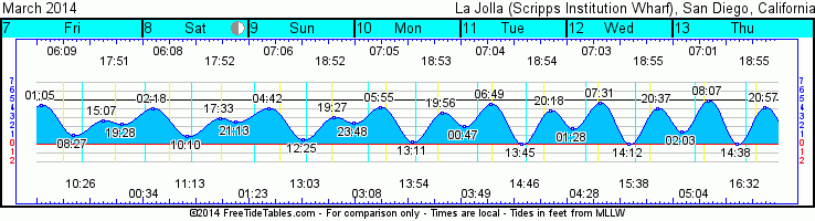
 Tides for La Jolla (Scripps Institution Wharf) starting with March 7, 2014.

www.saltwatertides.com
Day        High      Tide  Height   Sunrise    Moon  Time      % Moon
           /Low      Time    Feet    Sunset                    Visible
 
F    7     High   1:04 AM     4.4   6:09 AM    Rise 10:25 AM      33
     7      Low   8:27 AM     1.0   5:51 PM
     7     High   3:09 PM     2.7
     7      Low   7:28 PM     2.3
 
Sa   8     High   2:17 AM     4.1   6:08 AM     Set 12:34 AM      43
     8      Low  10:09 AM     0.9   5:52 PM    Rise 11:13 AM
     8     High   5:31 PM     2.9
     8      Low   9:15 PM     2.5
 
Su   9     High   4:43 AM     4.0   7:07 AM     Set  1:23 AM      52
     9      Low  12:24 PM     0.6   6:52 PM    Rise  1:02 PM
     9     High   7:26 PM     3.2
     9      Low  11:50 PM     2.4
 
M   10     High   5:56 AM     4.2   7:05 AM     Set  3:08 AM      62
    10      Low   1:12 PM     0.4   6:53 PM    Rise  1:53 PM
    10     High   7:55 PM     3.5
 
Tu  11      Low  12:48 AM     2.0   7:04 AM     Set  3:50 AM      71
    11     High   6:50 AM     4.5   6:54 PM    Rise  2:45 PM
    11      Low   1:45 PM     0.1
    11     High   8:17 PM     3.7
 

Saturday, March 1, 2014

Plenty of surf and more on the way!


“Don’t surf in POO!!!!!!”

WOW…I mean…WOW!  What a few days of crazy weather and BIG surf!  It’s not over yet!  We have a few more days of big surf…and then more swells on the way!  The bomber swell we saw today (Saturday) will peak overnight and by dawn on Sunday we’re looking at fading swell but still well into the DOH range.  Swell drops rapidly through the day with HH-OH (6-8’) with some OH+ sets still making it through.  Look for conditions to improve significantly as the winds calm WAAAAAAAAAAY down BUT water quality will be less than ideal.  Monday kicks off the week with HH-HH+ waves still on the fade.  Waist/chest high by sundown.  Tuesday morning is the smallest surf of the week with waist/chest high surf but another new WNW groundswell makes it way into So Cal midday. This swell will be significantly smaller but we’re still looking at HH by nightfall. Super long period intervals so be patient.  Wednesday the swell is still building with HH-OH waves throughout the day and consistency improves.  Swell peaks midday.   

Thursday we’re looking at the backside of that swell and HH waves to start the day, backing off just slightly through the day.  Friday looks still pretty fun with chest/shoulder high waves through the day.  The good news is that there’s yet another WNW swell filling in late Friday. From the looks of the storm it’s going to be a shorter lived swell with the peak hitting overnight but HH waves for Saturday morning. Waves taper off slowly through the day.  Luckily Mother Nature looks to be sending us more waves with another NW groundswell in the mix for the next Monday or so.  That’s another nice long period groundswell.

Weather wise we’re looking at the tail end of this big rain/wind maker. Scattered showers possible through Sunday but mostly sunny and light NW winds.  A few clouds Sunday night and east winds. The rest of the week we’re looking at improving weather with some scattered clouds along the coast but that also means SUNSHINE!  Air temps slowly warm back up into the mid to high 60s by the middle of the week along the coast.  Thursday we may see a little dip in air temp and a few more clouds but then things warm up for the weekend with some low/mid 70s!  YAY!  Tides are fairly extreme right now with a pretty high mid-morning tide for a few days backing off to a negative low in the mid-afternoon before it races back up overnight.  By the middle of the week we’ll see a morning low tide and a midday high. Water temps in the high 50s.  And of course, after an 1”-2” of rain throughout the county please be wary of impaired water quality.  The big surf certainly helps mix things up but we’re still looking at almost the whole winter’s worth of “junk” washing out the stormdrains from miles upstream and emptying into the ocean.  You might not see it but trust me, it’s there! Be smart don’t surf in poo (or all the other junk that’s there!).

Stay wet (but healthy) San Diego!
Mish


Gotta love buoy readings like these!


A water spout caught off Rosarito, Mexico 
(courtesy of KUUUUUUUUUUSI news)


Tides for La Jolla (Scripps Institution Wharf) starting with March 2, 2014.

www.saltwatertides.com
Day        High      Tide  Height   Sunrise    Moon  Time      % Moon
           /Low      Time    Feet    Sunset                    Visible
 
Su   2      Low   3:24 AM    -0.1   6:15 AM    Rise  6:57 AM      0
     2     High   9:36 AM     5.5   5:47 PM     Set  7:40 PM
     2      Low   3:48 PM    -0.7
     2     High  10:06 PM     5.3
 
M    3      Low   4:11 AM    -0.1   6:14 AM    Rise  7:36 AM      3
     3     High  10:21 AM     5.0   5:48 PM     Set  8:44 PM
     3      Low   4:24 PM    -0.1
     3     High  10:44 PM     5.2
 
Tu   4      Low   5:01 AM     0.1   6:13 AM    Rise  8:16 AM      8
     4     High  11:09 AM     4.3   5:49 PM     Set  9:46 PM
     4      Low   5:00 PM     0.6
     4     High  11:24 PM     5.1
 
W    5      Low   5:55 AM     0.4   6:12 AM    Rise  8:57 AM      15
     5     High  12:03 PM     3.6   5:49 PM     Set 10:45 PM
     5      Low   5:38 PM     1.3
 
Th   6     High  12:09 AM     4.8   6:10 AM    Rise  9:40 AM      24
     6      Low   7:01 AM     0.8   5:50 PM     Set 11:41 PM
     6     High   1:14 PM     2.9
     6      Low   6:21 PM     1.8
 

Tuesday, February 25, 2014

Big rain and HUGE WSW windswell on the way!


Update on all the craziness about to land on SoCal in the next week!  Wednesday will start off with waist high surf but later in the day we’ll see a new NW groundswell make its way to our shores Thursday.  Surf will pick up overnight to shoulder/HH with some HH+ standouts at the better winter breaks.  Conditions will already get a little dicey with mild overnight rain and ESE winds picking up overnight.  That swell peaks through the night and into Friday morning.  As it tapers off the weather pretty much takes over for the rest of the weekend and the skies unleash on Southern California giving us some much needed rain…and lots of it!  Bottom line is…rain, wind, rain, wind and more rain for Friday and Saturday.  As far as surf goes the NW groundswell tapers off through the day Friday but the next big storm that’s getting sucked up into us from the south (the good ol’ Pineapple Express) is going to bring a huge WSW windswell.  Saturday waves start in the shoulder/HH range and quickly increase into the 3-4’ overhead range by nightfall.  

Sunday the swell peaks with DOH and DOH+ waves along our coast.  Remember this will be out of the WSW so you’re looking at summer breaks for the most direct swell but west and north facing beaches will see plenty of their share as well.  As the swell progresses there will be more west in it at it moves north.  That means more large close out sets at the west facing beaches.  Big surf remains the story all day but decreases after the peak Sunday morning. We’re still looking at OH surf by nightfall.  Monday morning look for HH swell but dropping quickly through the day and back down to waist/chest high by nightfall.  Tuesday morning is looking about the same but a nice new WNW groundswell looks to be filling in late Tuesday with some long period and inconsistent swell.  Wednesday is going to see some larger surf with size gradually picking up through the day to chest/shoulder high.  We may see more inclement weather however so we’ll have to watch that and see how that all pans out next week.

Weather is really the big driver this weekend.  Three waves of storms will make landfall over the next 5 days.  The first band arrives Wed night with late rain overnight and into Thursday morning.  Light ESE winds come along with that one so conditions should still be surfable especially at some of the breaks that hold those nice S winds.  Friday is D-Day! That second band of rain moves in with heavy rain starting in the pre-dawn hours and gusting winds through the day in the 25-30mph range and gusts to 40mph.  Really heavy rain all day will be accompanied by the occasional thunderstorm.  Probably a good day to buy your Netflix membership and invest heavily in popcorn and hot chocolate!   More heavy rain through the night and for most of Saturday with slightly calmer winds but still plenty gusty.  The third wave of rain is much lighter showers Saturday evening and through Sunday. Winds back way down and blow moderately out of the east.  Tough to say when conditions will be surfable after all those gusty winds but Sunday afternoon might be a good call.  Forecast looks like S winds for the start of the work week.  Light overnight Sunday and into Monday before picking up in the late morning and through the night.   

Water temps in the high 50s/low 60s.  New moon Saturday will be causing some extreme tides.  Big highs in the early morning and super drained out lows in the early afternoon before heading back up for the late evening push.  Look for flooding in the low lying areas on Sat and Sun as that huge swell moves in and morning high tide pushes.
So, while the best days are looking like early Thursday, midday Sunday and next Monday morning please remember that the water quality will be extremely questionable.  Waves will also be quite large so be smart and surf away from lagoon/river mouths and storm drains and in size that fits your ability. 

Stay wet San Diego!
Mish


Tides for La Jolla (Scripps Institution Wharf) starting with February 26, 2014.
Day        High      Tide  Height   Sunrise    Moon  Time      % Moon
           /Low      Time    Feet    Sunset                    Visible

W   26      Low  12:13 AM     1.5   6:20 AM    Rise  4:03 AM      16
    26     High   6:30 AM     5.8   5:44 PM     Set  3:10 PM
    26      Low   1:19 PM    -1.2
    26     High   7:41 PM     4.3

Th  27      Low   1:05 AM     0.9   6:19 AM    Rise  4:51 AM      8
    27     High   7:19 AM     6.1   5:45 PM     Set  4:18 PM
    27      Low   1:58 PM    -1.4
    27     High   8:17 PM     4.8

F   28      Low   1:52 AM     0.4   6:18 AM    Rise  5:35 AM      3
    28     High   8:06 AM     6.2   5:45 PM     Set  5:27 PM
    28      Low   2:35 PM    -1.4
    28     High   8:53 PM     5.1

Sa   1      Low   2:38 AM     0.0   6:17 AM    Rise  6:17 AM      0
     1     High   8:51 AM     6.0   5:46 PM     Set  6:34 PM
     1      Low   3:12 PM    -1.1
     1     High   9:29 PM     5.3

Su   2      Low   3:24 AM    -0.1   6:15 AM    Rise  6:57 AM      0
     2     High   9:36 AM     5.5   5:47 PM     Set  7:40 PM
     2      Low   3:48 PM    -0.7
     2     High  10:06 PM     5.3

Monday, February 24, 2014

Huge surf and intense rain on the way!

Super quickie short forecast with the full report tomorrow...

Small (fluctuating with the tide) waist high surf for the next few days thru Wednesday.  Then we'll see some new WNW groundswell fill in Thursday and Friday along with the first really big storm in the past few years. Winds will pickup and blow onshore while the head high surf rolls in all day Thursday and into Friday. The bad news is that the Mother Lode of rain will unleash starting Friday in the wee hours of the morning.  Expect dumping rain all day with gusty onshore winds. Weather forecasts are calling for 1-1.5" of rain between 4am and 10pm. Yuck!  The surf picks up even more late Friday and early Saturday with OH to 2-3' OH but the wind picks up too with gusts forecasted at 30-35mph. That's ugly!  Another band of rain comes through Saturday late afternoon and into Sunday. Surf really picks up and peaks Sunday midday with WSW surf in the double overhead range.  The good news is that the winds will have backed down significantly so things will be cleaning up. We'll still see some moderate SW winds though so conditions will be better but still questionable.

Some higher tide swings will make for some really interesting conditions for the low lying areas around town as that DOH surf shows up.  Much cooler air temps as well!

It'll see how thing progress over the next 24 hrs and update things tomorrow.

All for now...
Stay wet San Diego! 

Mish

Monday, February 17, 2014

More fun medium sized surf and sun!


Happy President’s Day!  Tuesday we’ve got a nice NW short period ground swell filling in with some shorter period NW windswell on top of it.  We’ll see fun waves in the chest/shoulder high range with some HH waves at the better winter spots.  Surf should be fairly consistent too so lots of waves to share!  Wednesday things taper off a bit to waist/chest high and then bump up again Thursday as a smaller WNW shorter period swell moves in for more waist high waves.  A slightly bigger NW groundswell fills in Friday. This one will be fairly consistent too but short lived as we really only see chest high waves for the day. Early Saturday things quiet down with waist high waves but it looks like we’re going to start seeing some SW groundswell late Saturday and into Sunday.  The angle of this swell is aimed a bit more at Mexico but we should see some waist/chest high waves at the better summer spots for Sunday and early Monday.  Smaller surf for Tuesday but it looks like a long period WNW groundswell should be showing up around Wed or so.  The high pressure system seems to be kicking all the storms fairly north of us and out of our swell window early so we’ll have to watch the models to see if that swell makes it to us.  Cross your fingers!

Unfortunately, it looks like more fantastic sunny warm weather for us here in So Cal. Slightly cooler to start the week with air temps in the low 60s along the coast a bit more clod coverage but things should clear up by midweek and we should see temps back up into the mid-70s by the end of the week.  No rain in sight for the next 10 days at least!  Mild winds too with light E winds this evening and light SW winds during the day thru Thurs before turning more northerly.  Water temps are in the high 50s/low60s. Cooler temps seem to be south of Pt. Loma.  Tides are moving just enough to give us a little push every day.  For the next few days look for a late morning high tide push going out to a medium low just before sunset. 


Looks like some fun surf ahead of us!
Stay wet San Diego!
Lates,
Mish  


My son and I having a little paddle adventure in the kelp beds on Friday.


Tides for La Jolla (Scripps Institution Wharf) starting with February 18, 2014.

www.saltwatertides.com
Day        High      Tide  Height   Sunrise    Moon  Time      % Moon
           /Low      Time    Feet    Sunset                    Visible
 
Tu  18      Low   4:39 AM     1.0   6:29 AM     Set  8:18 AM      92
    18     High  10:37 AM     4.2   5:37 PM    Rise  9:20 PM
    18      Low   4:45 PM     0.5
    18     High  11:14 PM     4.5
 
W   19      Low   5:25 AM     1.1   6:28 AM     Set  8:53 AM      86
    19     High  11:18 AM     3.8   5:38 PM    Rise 10:18 PM
    19      Low   5:11 PM     1.0
    19     High  11:50 PM     4.5
 
Th  20      Low   6:25 AM     1.2   6:27 AM     Set  9:32 AM      78
    20     High  12:14 PM     3.1   5:39 PM    Rise 11:17 PM
    20      Low   5:42 PM     1.4
 
F   21     High  12:38 AM     4.5   6:26 AM     Set 10:15 AM      69
    21      Low   7:48 AM     1.2   5:40 PM
    21     High   1:44 PM     2.7
    21      Low   6:27 PM     1.8
 
Sa  22     High   1:47 AM     4.5   6:25 AM    Rise 12:17 AM      59
    22      Low   9:26 AM     0.9   5:40 PM     Set 11:03 AM
    22     High   3:51 PM     2.6
    22      Low   7:58 PM     2.2
