Monday, June 18, 2012

Small to medium combo swell midweek then small.


Greeting Earthlings!  I’m back from my travels and it looks like we’re sitting on some small surf!  We’ve got some fading background S swell that’s mostly passing us by and some small NW wind swell that’s giving us knee high surf. We won’t see much change Tuesday except less SW with more knee high surf.  Wednesday we should see some NW wind swell that will bump surf into the knee/waist high range.  The good news is that we’ll see some combo swell as a small SW ground swell helps wave size on Thursday as surf at the better summer spots bump up to waist high and the occasional chest high set. We’ll keep seeing that NW wind swell too.  Friday will be the “biggest” day as the swells peak and we see waist/chest high surf around town, mostly west and south facing beaches.  Most NW wind swell for the weekend as another little messy system moves down the coast.  Saturday will see some waist and occasional chest high set with Sunday looking smaller in the knee/waist range.  Both hemispheres aren’t looking very encouraging in terms of surf for next week.  Cross your fingers!

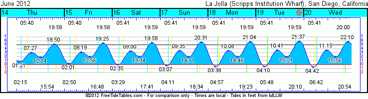
It looks like June Gloom is definitely upon us here on the coast.  Looks for patchy fog and slight clearing (if you’re lucky) along the coast for most of the week.  Air temps in the mid60s during the day and low 60s/high 50s at night.  Unfortunately it’s also going to remain fairly humid when/if it does clear midday.  Light onshore winds in the morning with light/moderate west winds midday, turn the page…and repeat thru Thursday.  By Friday we’re looking at slightly more southerly winds holding on through next weekend.  Water temps are holding in the mid60s.  Hopefully a few more south swells will push some of the warm stuff our way soon.  Tides are a bit extreme right now as we have the New Moon on Wed (The Summer Solstice…longest day of the year!) but this time of year we’re not seeing the huge swings between high and low tides.  The morning sessions will enjoy a nice little tide push as will the evening sessions.  The midday sessions will see minimal tidal movement.

Some surfable and fun sized surf midweek with a combination of NW wind and SW swells…enjoy!

Ciao!
Mish

Ocean Notes:

1)       Wow, lots going on as we kick off the summer (the Solstice is Wednesday you know!).  This Thursday we’ll see the first of the Encinitas Classic Car Nights . It’s the third Thursday of each summer month from 5:30pm – 7:30pm.  Not only will there be some sweet rides to check out but there will also be bands at the SMOG Test Only stage and Cardiff Classics stage.

2)      This Wednesday is also International Surfing Day!  Surfrider San Diego Chapter will be co-sponsoring a cool event at the Paradise Point Resort…free new Taylor Steele flick (suggested $10 donation) and “complimentary beverages and bites”.  What else are you going to do Wednesday night? Check it out!

3)      Green tips from the Environmental Protection Agency (EPA) Clean greener: If you're going to wash the car, deck, boat, or RV– be sure to look for the Design for the Environment (DfE) label to quickly identify and choose cleaning products that are safer for families and also help protect the environment. Look for the DfE label on grill cleaners as well. For more info click onto the EPA website: http://www.epa.gov/dfe

4)      Ok, here’s something easy on the eyes…surf where you might not expect it.  See, we get more than TVs, tennis shoes and baseball caps from China!  Good surf!

5)      And I’m gong to end it with a BANG!  Not sure how I missed this last week but Day 5 of the Volcom Pro took a little detour when a massive swell sent paddle in waves into the 20’+ range.  They cancelled the contest for the day (a bit of a bone of contention for some) and watched as the big-wave surfers had a hay day!.  Dang, talk about some BIG GNARLY WAVES!


Tides for La Jolla (Scripps Institution Wharf) starting with June 19, 2012.

www.saltwatertides.com
Day        High      Tide  Height   Sunrise    Moon  Time      % Moon
           /Low      Time    Feet    Sunset                    Visible
 
Tu  19      Low   4:10 AM    -0.6   5:41 AM    Rise  5:48 AM      0
    19     High  10:41 AM     3.7   8:00 PM     Set  8:11 PM
    19      Low   3:21 PM     2.1
    19     High   9:37 PM     5.9
 
W   20      Low   4:42 AM    -0.7   5:41 AM    Rise  6:42 AM      0
    20     High  11:15 AM     3.7   8:00 PM     Set  8:54 PM
    20      Low   3:56 PM     2.1
    20     High  10:10 PM     5.8
 
Th  21      Low   5:15 AM    -0.6   5:41 AM    Rise  7:38 AM      1
    21     High  11:50 AM     3.8   8:01 PM     Set  9:34 PM
    21      Low   4:34 PM     2.2
    21     High  10:45 PM     5.6
 
F   22      Low   5:50 AM    -0.5   5:42 AM    Rise  8:37 AM      4
    22     High  12:28 PM     3.8   8:01 PM     Set 10:11 PM
    22      Low   5:16 PM     2.2
    22     High  11:22 PM     5.3
 
Sa  23      Low   6:25 AM    -0.3   5:42 AM    Rise  9:36 AM      10
    23     High   1:09 PM     4.0   8:01 PM     Set 10:46 PM
    23      Low   6:07 PM     2.3

Wednesday, June 13, 2012

More NW wind swell and some small S too!


(I’m heading out on vacation so the next report won’t be until next Monday the 18th)

Oh boy it’s another holiday weekend coming up AND (sing it with me now…) “SCHOOOOOOOOOOOOL’S OUT FOR SUMMER!!!!!”  To kick off the first weekend of many kiddos summer vacation we’re looking at some combo WNW pseudo groundswell (ok, just call it wind swell) mixed in with some super long period SW groundswell.  For Thursday that translates into waist/chest high decently consistent surf at W and N facing beaches with very VERY inconsistent waist high surf at the S facing beaches.  A bit more S on Friday with decreasing WNW.  The weekend (Sat/Sun) is looking like mostly the left overs of the S swell so…hmmmmmm, waist/knee high.  The W and N facing beaches should see some tiny NW wind swell in the background.  Best to hit the beach breaks with a fun shortboard and the reefs with a log…a BIG log!  Late Monday is looking like the next opportunity for new swell with more NW wind swell showing up to help the toe high surf into the knee high range.  Luckily Tuesday we’re also looking at some new SW ground swell that looks to finally have a little gusto in it with surf picking up for the end of next week.  Again, that’s a ways off but the storm models look promising.

Our weather patterns seems sort of painfully steady with overcast skies sticking to the coastline and low to mid60s.  A small system will deliver a chance of drizzles tonight (yes, really!) with a bit more sunshine for Fri and Sat.  Father’s Day looks like a decently nice day with the warmest air temps all weekend (high 60s/low 70s) and maybe even some sunshine by midday.  We’ll have a little S winds tonight and early east winds before becoming westerly.  S winds on Thurs night and Fri as our pal “coastal Eddy” swoops into town for the day.  Nicer days with lighter S winds Sat and light W winds by midday Sun.  We’re seeing only minor tidal movement midday with big tide swings starting up around sunset (big high tides) and negative lows through the middle of the night.  Water temps have cooled off a tad with temps in the 64-66 degree range around the county.

I hope everyone has a nice Father’s Day weekend and if you’re getting out of school…have a great first summer weekend!

Outta here!
Mish

Ocean Notes:

1)       Here’s an app you might not have… Trash Backwards…an upp for UPCYCLING your garbage…do something with it before it heads to the recycling center!  Figure out what to do with just any anything you have that you might want to recycle!  Just try it…you’ll be surprised!

2)      And Dad probably doesn’t need ANOTHER pair of on-sale boardshorts.  Why not check out the Treehugger Green Gift Guide to give you some ideas.  Shoot…upcycle the boardshorts using the Trash Backwards app!

3)      Don’t forget about International Surfing Day on Wednesday June 20th!  Head over to Paradise Point Resort and Spa with the San Diego Surfrider for some fun eats, treats, beverages and the world premiere of Taylor Steele’s new surf flick Here & Now.

4)      And if you’re one of the thousands who will flock to the Fair this weekend also check out Surfrider’s award winning Ocean Friendly Garden display.  Get some good ideas for your own backyard while you’re there!

5)      Well, by now you might have heard that it was PUUUUUUUUMPING for the Volcom Pro in Fiji this past week.  If you don’t believe it then here’s the proof. Put your seat belt on cause this might just blow you AWAY!

6)      And I try to save the best for last…you’ll sleep soundly tonight dreaming about this…Kelly Slater just rocked the house and made it look so amazingly easy to rip during the finals of the Volcom Pro to win first place.  A-MA-ZING!!!


Tides for La Jolla (Scripps Institution Wharf) starting with June 14, 2012.

www.saltwatertides.com
Day        High      Tide  Height   Sunrise    Moon  Time      % Moon
           /Low      Time    Feet    Sunset                    Visible
 
Th  14      Low   1:21 AM     0.8   5:40 AM    Rise  2:15 AM      27
    14     High   7:27 AM     3.1   7:59 PM     Set  3:55 PM
    14      Low  12:14 PM     1.9
    14     High   6:50 PM     5.2
 
F   15      Low   2:01 AM     0.3   5:40 AM    Rise  2:50 AM      19
    15     High   8:19 AM     3.2   7:59 PM     Set  4:49 PM
    15      Low  12:56 PM     2.0
    15     High   7:25 PM     5.4
 
Sa  16      Low   2:35 AM     0.0   5:40 AM    Rise  3:28 AM      12
    16     High   9:00 AM     3.4   7:59 PM     Set  5:42 PM
    16      Low   1:34 PM     2.1
    16     High   7:58 PM     5.6
 
Su  17      Low   3:07 AM    -0.3   5:41 AM    Rise  4:10 AM      6
    17     High   9:35 AM     3.5   8:00 PM     Set  6:34 PM
    17      Low   2:11 PM     2.1
    17     High   8:31 PM     5.7
 
M   18      Low   3:38 AM    -0.5   5:41 AM    Rise  4:57 AM      2
    18     High  10:08 AM     3.6   8:00 PM     Set  7:24 PM
    18      Low   2:46 PM     2.1
    18     High   9:04 PM     5.8

Sunday, June 10, 2012

Some fun combo swell for the start of the week


Aloha all!  We’re rolling into the work week with some NW wind swell on top of some new SW ground swell.  Monday we’re looking at some combo surf in the waist/chest high zone at most beaches with some bigger sets at the south facing beaches.  The SW is going to hang in for most of the day and fade a bit by Tuesday with less NW wind swell and some waist/chest high south swell.  Late Tues we’re looking at very little swell from any direction as Wednesday looks like knee high surf with small long period SW swell.  Late Wed a new NW swell fills in and surf bumps up through the night with some chest high surf by Thursday morning and building to shoulder high for the middle of the day.  Size should hold for most of Friday and then back off Saturday into the waist high range and taper off through the rest of the weekend.  The N Pacific holds some potential for wind swell still and the S Pacific looks like there is some potential for surf waaaaay off in the distance but there aren’t any real juicy swells heading our way at this point.

Weather wise we’re looking at a nice sunny day Monday with more marine layer and early and late fog later this week.  Air temps are looking in the mid to upper 60s all week.  Winds bump will be an issue in the mornings with west winds blowing Monday and Tuesday night.  Water is warming up nicely…high 60s along most of SD’s coastline. 

Gotta run but enjoy the surf Monday…more details in the next report/forecast!
Mish


Tides for La Jolla (Scripps Institution Wharf) starting with June 11, 2012.

Day        High      Tide  Height   Sunrise    Moon  Time      % Moon
           /Low      Time    Feet    Sunset                    Visible
 
M   11     High   3:25 AM     3.6   5:40 AM    Rise 12:41 AM      55
    11      Low   9:45 AM     1.0   7:58 PM     Set  1:11 PM
    11     High   4:46 PM     4.5
    11      Low  11:22 PM     1.7
 
Tu  12     High   4:53 AM     3.2   5:40 AM    Rise  1:12 AM      45
    12      Low  10:38 AM     1.4   7:58 PM     Set  2:06 PM
    12     High   5:33 PM     4.8
 
W   13      Low  12:31 AM     1.3   5:40 AM    Rise  1:43 AM      36
    13     High   6:19 AM     3.1   7:58 PM     Set  3:00 PM
    13      Low  11:28 AM     1.6
    13     High   6:14 PM     5.0
 
Th  14      Low   1:21 AM     0.8   5:40 AM    Rise  2:15 AM      27
    14     High   7:27 AM     3.1   7:59 PM     Set  3:55 PM
    14      Low  12:14 PM     1.9
    14     High   6:50 PM     5.2
 
F   15      Low   2:01 AM     0.3   5:40 AM    Rise  2:50 AM      19
    15     High   8:19 AM     3.2   7:59 PM     Set  4:49 PM
    15      Low  12:56 PM     2.0
    15     High   7:25 PM     5.4
 

Thursday, June 7, 2012

Linger NW, new S, sunshine...it's all good!


Greetings all!  We’re looking at some fading NW wind swell that’s been producing some pretty nice waves around town lately. Heard rumors of some dredging 7-9’ waves around N. County this morning as the tide turned around.  YOWZA!  Friday things will quiet down just a smidge with less NW wind swell (chest/shoulder in the AM and waist/chest by nightfall) but there’s a little SW groundswell that’s we’re already starting to see on some of the buoys.  The 20 second period will mean very very inconsistent S for the next day or so and since it’s not the most powerful swell we’re really only looking at some waist high waves for south facing beaches late Friday.  Swell picks up over Sat a little with some waist/chest high surf and on into Sunday.  We’ll also see some new NW wind swell helping the surf no Saturday and into Sunday…waves at west and north facing beaches in the chest and shoulder high range by late Sat and early Sun.  Both swells fade on Monday with the S lasting a hair longer and hanging on until Tuesday with some knee/waist high surf.  Looks like some new wind swell for Wednesday but surf only in the waist high range.  The southern hemi looks like it’s going to pick up for next weekend (figures, I’ll be out of town!) with a decent storm looking like it might sit and spin a little while down there by Tazzieland before moving on.  I’ll keep my eye on it and let you know.

We’ve been enjoying some mighty nice weather the past few days…waking up to sunshine and warm beach temps.  There’s a bit more marine layer in our near future with patchy fog tonight and early tomorrow but clearing with sunshine and similar air temps by midday.  Same patterns for most of the weekend…perhaps a hair cooler.  Light south winds will pick up each day (ugh…Springtime!) but I’m not anticipating it to get to blustery.  Water temps seem pretty variable right now (see Terrafin chart below) with the southern half of the county getting some low 60s and a nice bubble of warm water (high 60s) hanging up around O’side.  We’re seeing some fairly drained out early morning tides moving to a medium high by mid-afternoon and then back down before sunset.

Looks pretty fun for awhile…a little spring breeze mixed in with some wind swell and early S swell…surf it!

Lates,
Mish

Ocean notes:

1)       This weekend has all sorts of fun stuff going on.  If you find yourself in Encinitas on Sunday between 10am and 4pm cruise on down to Cottonwood Creek Park and check out Encinitas Environment Day!!!  There are booths of good organic food, exhibits and vendors, kids activities and of course free raffle prizes!

2)      Our fridges are full of reusable food containers these days.  Check out this Earth 911 link to find out the best way to reuse all of that plastic and glass!

3)      Here’s a fun video from Surfer Mag…fun Indo with some pros…and some “no-so-pros”…just watch it!

4)      This is a must read!  Volunteer pros teaching autistic kids to surf.  . Way to go everyone!  What a great day at The Bu!

5)      I’d watch this video of Taj, Mick and Kelly even if these three guys were just walking down the street…but they’re not…they’re RIPPING FIJI!   

Log on to www.terrafin.com to check out the water temps near you!


Tides for La Jolla (Scripps Institution Wharf) starting with June 8, 2012.

www.saltwatertides.com
Day        High      Tide  Height   Sunrise    Moon  Time      % Moon
           /Low      Time    Feet    Sunset                    Visible
 
F    8     High  12:08 AM     5.5   5:40 AM     Set 10:14 AM      84
     8      Low   7:11 AM    -0.7   7:56 PM    Rise 11:36 PM
     8     High   1:56 PM     4.0
     8      Low   7:05 PM     2.2
 
Sa   9     High   1:03 AM     4.9   5:40 AM     Set 11:16 AM      75
     9      Low   8:01 AM    -0.1   7:57 PM
     9     High   2:54 PM     4.1
     9      Low   8:24 PM     2.3
 
Su  10     High   2:07 AM     4.1   5:40 AM    Rise 12:09 AM      65
    10      Low   8:53 AM     0.5   7:57 PM     Set 12:14 PM
    10     High   3:52 PM     4.3
    10      Low   9:54 PM     2.1
 
M   11     High   3:25 AM     3.6   5:40 AM    Rise 12:41 AM      55
    11      Low   9:45 AM     1.0   7:58 PM     Set  1:11 PM
    11     High   4:46 PM     4.5
    11      Low  11:22 PM     1.7
 
Tu  12     High   4:53 AM     3.2   5:40 AM    Rise  1:12 AM      45
    12      Low  10:38 AM     1.4   7:58 PM     Set  2:06 PM
    12     High   5:33 PM     4.8
 

Tuesday, June 5, 2012

New NW wind swell and some smaller surf ahead


Madames et monsieurs…well, the wind wasn’t actually as horrible as the wind charts made them out to be…some winds for sure but also some pretty fun surf.  That S swell is still on the fade and the new NW wind swell is building quickly.  Buoys are jumping with surf for Wednesday looking to be in the HH+ range.  The swell peaks midday with some consistent and sizable waves…wind conditions don’t look too bad so it should be a fun day of surf.  Surf backs down Thursday with lingering NW wind swell in the chest high range and further still for Friday in the waist high zone.  We should see a little hiccup of new SW ground swell Friday with very inconsistent waist high waves showing up at the south facing spots.  Looks surf gets pretty small for the rest of the weekend with lingering S swell.  Waves in the knee/waist high range for Saturday and Sunday.  Looks like we should see some small SW groundswell for the start of next week.  No huge storms in the southern hemi but one looks like it spun just long enough to send us a little something to kick off our week.

The winds and steep full moon tides will be the deciding factor for Wed with some early but SE winds all night and into the morning and then picking up out of the west midday.  Looks like the midmorning winds will be the lightest.  Looks for some bump on the super early dawn patrol waves not to mention the drained out tide.  Luckily we’ll see some more sunshine tomorrow with decent air temps in the high 60s.  Looks for a similar pattern for Thursday and Friday with a big more marine layer in the early AM and late evening.  Big singing tide with an early negative low and medium high midday going to a medium low a few hours before sunset.  Water’s feeling nice especially midday with some sunshine on your back. 

Don’t forget the SPF!
Au revoir!
Mish

Ocean Notes:

1)       Here’s a great read from the NY Times… "The Darker Thrills of EcoTourism" from today’s paper.  Author recounts thee travels of Andrew Blackwell, a Brooklyn-based author and journalist, who highlights the not-so-green parts of our planet exposing the uglier side of what humans are doing to our planet.  It’s a far cry from the pristine beaches we seek out.  An eye opener for sure!

2)      Whatcha doing this Saturday?  Come check out the Carlsbad Beach Fest!  It’s got everything from a Triathalon, K, surf contests, SUP races, Zumba-thon, booths, activities for kiddies, food court, beach clean up, sand art, live entertainment and of course drawings and prizes.  What else would you want to do?  It’s a mile of summery beach fun!  Check it out!

3)      And if you hadn’t heard…this past Saturday President Obama declared June National Ocean Month!  Read more to find out what exactly the administration is going to do to celebrate…head to Disneyland? 

4)      Life in Tavarua now is mighty fine right now...especially if you’re John John Florence.  If you don’t believe me just check out these pics from Surfer Mag's coverage or just watch the final heat online!

5)      And for those of you looking for a nice new screen savers to drool over check out these entries to Surfing Mag’s Follow the Light contest.

6)      And if you like Shipsterns down in Tazzieland here is some great footage of the spot a little more calm but fun.

Tides for Point Loma starting with June 6, 2012.

www.saltwatertides.com
Day        High      Tide  Height   Sunrise    Moon  Time      % Moon
           /Low      Time    Feet    Sunset                    Visible
 
W    6      Low   5:36 AM    -1.5   5:41 AM     Set  8:04 AM      97
     6     High  11:59 AM     4.0   7:55 PM    Rise 10:15 PM
     6      Low   5:04 PM     1.7
     6     High  11:08 PM     6.2
 
Th   7      Low   6:24 AM    -1.1   5:41 AM     Set  9:10 AM      91
     7     High  12:52 PM     4.0   7:55 PM    Rise 10:58 PM
     7      Low   6:01 PM     1.9
     7     High  11:59 PM     5.5
 
F    8      Low   7:13 AM    -0.6   5:41 AM     Set 10:15 AM      84
     8     High   1:47 PM     4.0   7:56 PM    Rise 11:35 PM
     8      Low   7:07 PM     2.1
 
Sa   9     High  12:54 AM     4.9   5:41 AM     Set 11:16 AM      75
     9      Low   8:03 AM    -0.1   7:56 PM
     9     High   2:45 PM     4.1
     9      Low   8:26 PM     2.2
 
Su  10     High   1:58 AM     4.1   5:41 AM    Rise 12:09 AM      65
    10      Low   8:55 AM     0.5   7:57 PM     Set 12:14 PM
    10     High   3:43 PM     4.3
    10      Low   9:56 PM     2.0

Monday, June 4, 2012

It's gonna get windy for Tues


Yikes…kinda late on this one so it’s gonna be short.  Gusty south winds on tap for Tuesday morning so get on it early.  There will already be some light S winds on it but it’s going to get gusty by midday/early afternoon.  Still plenty of steep S swell with some nice shoulder/HH sets today and HH+ at the stand out summer south facing spots.  It’ll be fading tomorrow so dawn patrol is better especially with the full moon tides.   More sizable (shoulder/HH+) NW wind swell and less wind for Wed...with some morning glass for Thursday and Friday.  Update on Tuesday night…

Mish


Tides for La Jolla (Scripps Institution Wharf) starting with June 4, 2012.

www.saltwatertides.com
Day        High      Tide  Height   Sunrise    Moon  Time      % Moon
           /Low      Time    Feet    Sunset                    Visible
 
M    4      Low   3:59 AM    -1.7   5:41 AM     Set  5:52 AM      99
     4     High  10:26 AM     4.0   7:54 PM    Rise  8:29 PM
     4      Low   3:20 PM     1.6
     4     High   9:42 PM     6.8
 
Tu   5      Low   4:46 AM    -1.7   5:41 AM     Set  6:57 AM      99
     5     High  11:16 AM     4.0   7:55 PM    Rise  9:26 PM
     5      Low   4:09 PM     1.6
     5     High  10:28 PM     6.5
 
W    6      Low   5:34 AM    -1.6   5:40 AM     Set  8:04 AM      97
     6     High  12:08 PM     4.0   7:55 PM    Rise 10:16 PM
     6      Low   5:02 PM     1.8
     6     High  11:17 PM     6.2
 
Th   7      Low   6:22 AM    -1.2   5:40 AM     Set  9:10 AM      91
     7     High   1:01 PM     4.0   7:56 PM    Rise 10:58 PM
     7      Low   5:59 PM     2.0
 
F    8     High  12:08 AM     5.5   5:40 AM     Set 10:14 AM      84
     8      Low   7:11 AM    -0.7   7:56 PM    Rise 11:36 PM
     8     High   1:56 PM     4.0
     8      Low   7:05 PM     2.2

Friday, June 1, 2012

SW ground swell and NW wind swell for this week


Hola hola eh!  Sup So Cal?  Hope you’ve been catching some sliders lately.  It’s been small with mostly NW wind swell but there are still been some pretty fun waves.  We’re looking at a little more NW wind swell Saturday morning in the waist high range and the occasional chest high set.  For Sunday we’ll look for it to taper off a bit and deliver mostly knee/waist high waves.  Late Sunday look for some long period (that means inconsistent) SW ground swell to fill in. We’re looking at size to bump up to chest high by Monday morning (remember, it’ll be inconsistent) and the swell will continue to fill in through the day.  Swell peaks with some fun shoulder/HH waves and some HH+ at the stand out south facing summer spots by late in the day.  Holding S swell first thing in the morning before more NW wind swell kicks in as a small weather system drops in to town Tuesday.  The swell looks to fill in through the afternoon and into Wednesday morning as it peaks mid morning in the HH+ range and then starts to back down for the rest of the day.  Thursday seems to be an in between day with some left over wind swell in the waist/chest high range.  Although it’s a week away it looks like some storms down in the Southern Hemi should send us some decent ground swell for the end of next week.  More details as we approach the middle of next week.

We’ve had a variety of weather with marine layer, cool breezes mixed with sunshine.  Look for similar weather Saturday and more sun Sunday and Monday.  By Monday night and into Tuesday that next low pressure system will be making it’s way into town and we’ll see more clouds, a chance of drizzle and those dreaded south winds.  Luckily it’s not going to be one of those crazy wind storms so that sizable NW wind swell might be pretty fun!  Air temps in the mid to upper 60s for the rest of the weekend with only a slight dip in air temps as that system moves through Tuesday and then warming up again for the end of next week (and hopefully more SW groundswell!).  Full moon Monday means big water movement in the tides.  Negative lows over night lead to a medium high tide push for the early morning session.  Medium low midday then spikes up to a pretty high tide by sunset.  Water temps are so nice…mid 60s all around…upper 60s in spots.

Looks like some fun surf coming up. More S swells providing fun surf and warm water!

Yeehaw it’s starting to feel like summahtime!
Mish

Ocean Notes:

1)       To add to the plastic story that seems never ending (have you looked around your house and realized how much plastic there is?)…this inspiring story from some kids up north shows how every little (person) bit of help counts in the battle to clean up the planet.  Kids vs Crayola!

2)       And San Diego Coastkeeper has just released a great new FREE app called The Swim Guide .  It gives you the water quality at most San Diego beaches.  Check the water quality before you drive all the way there to check the surf!

3)      Are you still phasing out those “ole school” light bulbs at your house?  Why not score a cool and hip “GREEN LAMP” to go wit your new energy efficient bulbs?

4)      Surfline’s “ Sequence of the Week ” is a doozy…I would be standing in this barrel too…having a heart attack!

5)      And now for something completely surfy!  The Volcom Pro is back at Tavarua and it looks like there’s going to be some kickin’ swell for the contest that starts Sunday.  Can’t afford a beach front ticket to Fiji?  Well, log on and watch LIVE!


Tides for La Jolla (Scripps Institution Wharf) starting with June 2, 2012.

www.saltwatertides.com
Day        High      Tide  Height   Sunrise    Moon  Time      % Moon
           /Low      Time    Feet    Sunset                    Visible
 
Sa   2      Low   2:24 AM    -1.0   5:41 AM     Set  3:59 AM      90
     2     High   8:42 AM     3.9   7:53 PM    Rise  6:17 PM
     2      Low   1:44 PM     1.4
     2     High   8:11 PM     6.6
 
Su   3      Low   3:12 AM    -1.5   5:41 AM     Set  4:52 AM      96
     3     High   9:35 AM     4.0   7:54 PM    Rise  7:25 PM
     3      Low   2:32 PM     1.5
     3     High   8:56 PM     6.8
 
M    4      Low   3:59 AM    -1.7   5:41 AM     Set  5:52 AM      99
     4     High  10:26 AM     4.0   7:54 PM    Rise  8:29 PM
     4      Low   3:20 PM     1.6
     4     High   9:42 PM     6.8
 
Tu   5      Low   4:46 AM    -1.7   5:41 AM     Set  6:57 AM      99
     5     High  11:16 AM     4.0   7:55 PM    Rise  9:26 PM
     5      Low   4:09 PM     1.6
     5     High  10:28 PM     6.5
 
W    6      Low   5:34 AM    -1.6   5:40 AM     Set  8:04 AM      97
     6     High  12:08 PM     4.0   7:55 PM    Rise 10:16 PM
     6      Low   5:02 PM     1.8
     6     High  11:17 PM     6.2