Tuesday, August 14, 2012

Fading SW but more for the weekend!


Aloha all!  Is everyone exhausted from the heat, warm weather and fun surf this past weekend?  We’re just seeing the tail end of that SW swell with some NW wind swell lumped on top for Wednesday.  Surf backing down into the waist high range.  The quality and size will really vary depending on the tides as we near the New Moon on Friday. Thursday the surf backs down even farther to the thigh/waist high range.  Late Thursday we’ll see the start of the next SW swell. This one’s a little more steep than the previous swell but we should still see some fun waves.  Friday morning we’re looking at long interval waist/chest high surf.  Spots farther north and aimin’ south should pick up some pretty fun waves from this swell with slightly bigger sets in the shoulder/HH arena.  Tacked on to this swell will be some smaller FKA Hurricane Hector swell.  Hector came out from under Baja and swung in our general direction but sort of pooped out along the way.  We’ll see most of our energy coming from the original SW with some backup swell from Hector.   Shoulder high by the end of Friday and into Saturday.  Swell peaks Saturday but we’ll still see surf Sunday in the waist/chest range and then slightly smaller for the start of next week.  Looks like some longer period swell with more west in it for the start of next week.  No huge swells out there but it’ll give us something to ride for next week.

The heat’s finally starting to break at the coast.  We’ll be “dropping” down into the high-mid70s for the rest of the week and even slightly cooler (low 70s) for the weekend and next week.  We’ll still see some early morning clouds and late sunset clouds Wed with mostly sunshine Thursday and Fri.  A few more morning clouds coming back for the weekend.  Light and variable winds through the evening and mild for most of the day with a nice breeze by midday.  Water temperatures are a phenomenal 72-74 degrees.  Tides are not moving a lot in the morning hours…a mild high tide mid-morning to a medium low in the early afternoon but the super high tide  in the evening will surely slow some waves down a bit for those sunset sessions.

Count your blessings that it’s only 80 at the coast and 73 in the water…you could be in Phoenix where it’s forecasted to be 111 degrees tomorrow and not an ocean insight!

Mahalo!
Mish

Ocean Notes:

1)       While many cities are banning plastic you can still take your used grocery bags and recycle them at recycling centers at the store.  And what happens after you stuff it into that big cardboard box?  I’m glad you asked…check out this Youtube video showing how plastic bags are recycled.
2)      As many of us are heading to places more tropical, to the in-laws for a visit or just getting away from it all there are a few things you can do to not only cut down on your carbon footprint but save yourself money by not burning electricity when you’re not even home to use it.  Here are a few tips from Earth911.com.

3)      It’s THAT time of year…find a friend who has the biggest flat screen TV and hang on to your seats.  It’s the Billabong Pro at Teahupoo! Last year the surf went RICHTER and the tow session they had during the “too big to surf” stoppage.  The forecast isn’t as good as last year but Teahupoo and pro surfers never disappoint!

4)      And in case you aren’t reading this from Padang Padang…Chris Ward won the Rip Curl Pro there last Friday in some pretty nice conditions.  Here, judge for yourself!

5)      And we’ll end with a clip of summer session a few years ago...Malibu with Joel Tudor and Alex Knost…two guys who really know how to longboard! 


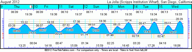
Tides for La Jolla (Scripps Institution Wharf) starting with August 15, 2012.

www.saltwatertides.com
Day        High      Tide  Height   Sunrise    Moon  Time      % Moon
           /Low      Time    Feet    Sunset                    Visible
 
W   15      Low   2:47 AM    -0.2   6:13 AM    Rise  4:17 AM      8
    15     High   9:11 AM     4.1   7:34 PM     Set  6:09 PM
    15      Low   2:17 PM     1.8
    15     High   8:29 PM     6.0
 
Th  16      Low   3:15 AM    -0.4   6:13 AM    Rise  5:17 AM      3
    16     High   9:36 AM     4.4   7:33 PM     Set  6:47 PM
    16      Low   2:54 PM     1.5
    16     High   9:05 PM     6.1
 
F   17      Low   3:44 AM    -0.4   6:14 AM    Rise  6:18 AM      0
    17     High  10:03 AM     4.7   7:31 PM     Set  7:23 PM
    17      Low   3:32 PM     1.3
    17     High   9:42 PM     6.0
 
Sa  18      Low   4:13 AM    -0.3   6:15 AM    Rise  7:20 AM      0
    18     High  10:32 AM     5.0   7:30 PM     Set  7:58 PM
    18      Low   4:13 PM     1.0
    18     High  10:20 PM     5.7
 
Su  19      Low   4:43 AM    -0.1   6:16 AM    Rise  8:24 AM      1
    19     High  11:03 AM     5.2   7:29 PM     Set  8:34 PM
    19      Low   4:56 PM     0.9
    19     High  11:01 PM     5.3

Saturday, August 11, 2012

More SW and warm water ahead!


So, how’s your week going?  Getting some surf?  There’s more on the way!  We’re seeing some nice SW swell around town and peaking tomorrow (Sunday) with some fun chest/shoulder high waves.  There were some nice HH+ waves farther up north in the OC/LA area.  It’s also getting backed up by the storm formerly known as Hurricane Gilma.  She took a nice northerly turn and threw some fun hurricane energy our way.  That will help with size Sunday and will taper off on Monday.  The good news is that we’re looking at continuing energy from the SW with more chest/shoulder high surf through Monday with probably some slightly bigger sets at the top summer spots.   Continuing into the start of Tuesday before it starts to back down.  Waist/chest for Wednesday morning and then back into the knee/waist range with some chest high sets for Thursday.  Then we’re seeing the next nice SW ground swell make an appearance.  We’ll start seeing the long period stuff late Thursday but Friday and Saturday will return to chest/shoulder high waves with better sets for the more southerly facing summer breaks and with plenty of surf for the weekend.  I’m also keeping and eye on tropical storm Hector who’s moving out from under the tip of Baja but projecting surf more westerly and needs to move more northerly to really give us any surf.

The weather looks like it’s going to cooperate and stay nice and warm with a slight cooling trend from the low 80s to high 70s along the coast by midweek.  Still seeing some early morning marine layer a few clouds by sunset.  Calm mornings with midday breezes picking up out of the west.  Doesn’t look too bad but things will have a little bump on them in the afternoon.  Water temps are a tremendous 70s-72 degrees all along the coast.  For those fishermen out there the tropical species are starting to show up!  Just make sure you are mindful of the new Marine Protected Areas around town.  It’s not worth the $5000 ticket!  Tides are pretty flat for the first part of the day with more water movement in the second half of the day.  The high tide around sunset is slowing things down a little so prepare for that if you head out for a sunset session.  That will get more extreme as we move through the week.

Looks like a fun weekend of surf and even some nuggets of surf through the week.

Have fun and lather up that SPF!
Ciao!
Mish

Ocean Notes:

1)       With fishing season going full throttle please be mindful and aware of the new marine protected areas along the coast.  If you have a fishing license it’s your responsibility to know the law.  Check out the Department of Fish and Game Marine Life Protection Act website with links to the mobile app of protection areas and Southern California page of maps and regulations.  It’s a minimum of $5000 if you get caught.

2)      And don’t forget about beach water quality. Here’s a great sight to bookmark…Coastkeeper’s San Diego County Beach Status website.  It’s got up to date information on beach closures and warnings. 

3)      And as we cruise through August some folks are staring at “Back to School” sales with great dread…or not.  How about throwing some green into that backpack?  Here are 9 eco-savvy school supplies from Treehugger.  There are actually a lot more green school supplies out there too.  These days the big name companies like Staples, Target and Office Depot have green alternatives to many supplies.  Just look around.

4)      Getting down to all things surf…here’s a great new flick that premiered last week…Fox’s new movie No Filter .  But be warned…it’s only good if you like killer surf with guys rippin’ on it!  J

5)      San Diego hasn’t seen a ton of good swell this month yet BUT other spots along the coast and farther south certainly have!  Surfline’s got the proof Just click here and enjoy!


Tides for La Jolla (Scripps Institution Wharf) starting with August 12, 2012.

www.saltwatertides.com
Day        High      Tide  Height   Sunrise    Moon  Time      % Moon
           /Low      Time    Feet    Sunset                    Visible
 
Su  12      Low   1:14 AM     0.8   6:11 AM    Rise  1:34 AM      30
    12     High   8:03 AM     3.4   7:37 PM     Set  3:59 PM
    12      Low  12:09 PM     2.7
    12     High   6:30 PM     5.1
 
M   13      Low   1:48 AM     0.4   6:11 AM    Rise  2:25 AM      22
    13     High   8:25 AM     3.6   7:36 PM     Set  4:45 PM
    13      Low  12:59 PM     2.4
    13     High   7:14 PM     5.4
 
Tu  14      Low   2:18 AM     0.1   6:12 AM    Rise  3:19 AM      14
    14     High   8:47 AM     3.9   7:35 PM     Set  5:29 PM
    14      Low   1:40 PM     2.1
    14     High   7:53 PM     5.7
 
W   15      Low   2:47 AM    -0.2   6:13 AM    Rise  4:17 AM      8
    15     High   9:11 AM     4.1   7:34 PM     Set  6:09 PM
    15      Low   2:17 PM     1.8
    15     High   8:29 PM     6.0
 
Th  16      Low   3:15 AM    -0.4   6:13 AM    Rise  5:17 AM      3
    16     High   9:36 AM     4.4   7:33 PM     Set  6:47 PM
    16      Low   2:54 PM     1.5
    16     High   9:05 PM     6.1
 

Wednesday, August 8, 2012

Some fun warm S swells on the way!


Is it just me or is it hot in here?  Hot and steamy…too bad we’re not all on vacation in some super tropical location!  Well, at least we have some surf.  We’ve been seeing some really steep SSE swell that’s been missing a lot of SD with the NW wind swell filling in for some waist high waves.  Spots up in north N. County have been seeing some shoulder/HH+ sets but that’s backing off to waist/chest for Thursday.  Look for waist high again at most SD beaches.  Late Thursday a new SW will be filling in for Friday morning.  Surf should bump back up into the waist/chest range for more of SD County as there’s more W in this SW.  The energy is much lower than this last swell but directed much better into our swell window.  Things back off a little Saturday but then Sunday afternoon we should see more SW swell and things hitting the chest/shoulder range for the summer south spots.  The icing on this cake is Hurricane Gilma.  While not the biggest baddest hurricane in town (in fact she doesn’t really hit hurricane status until Thursday) she’s turning a little more northerly which is good news if she continues to head our direction.  That swell will show up Monday/Tues with some fun energetic swell in the chest/shoulder high range with some larger HH sets (as long as she stays heading N).  And there’s more swell on the way too for the end of the week…looks promising!

So this heat wave that we’re having is going to stick around for a few more days, through the weekend and actually into next week!  Things will cool down a tad…from the low 80s to the high 70s by Monday along the coast.  Winds look nominal too…a welcome breeze to cool us off in the afternoon.  Very slight breeze out of the S for the AM and turning more SW by midday.  Temps remain warm through the night…high 60s.  UGH!  The best news is the water is in the low 70s throughout SD County with warmer water sitting offshore. Hopefully these next few swells will push that warmer water even farther north.  Tides aren’t really doing much over the next few days…in fact, practically nothing at all on Friday morning with a 0.1’ tide “swing” from high to low then a bit more water movement n the afternoon. 

Looks like some fun surf on it’s way…warm water…sunny skies…yup, we’re living the life folks.  Appreciate it!

Lates,
Mish

Ocean Notes:

1)       With the super hot weather in town for awhile SDG&E has declared a “Reduce Your Use” day tomorrow. This means we need to try extra hard to turn off electrical appliance during peak hours (11am-6pm).  This includes unplugging things that actually use energy even though they’re turned “off” like TVs, DVDs, computers, entertainment systems and phone and battery chargers.  You can even sign up and they’ll send you a notice letting you know when “Reduce Your Use” days are coming.  You can even get rewards on your SDG&E bill! Click HERE for more info.

2)       If you haven’t already cleaned out your closets this past Spring and have a house full of “STUFF” then you definitely need to watch this short 20 minute flick called, "The Story of Stuff".   It chronicles (in only 20 minutes) the story of production to destruction of all of our “stuff”.  A great flick and much see TV!

3)      And my most favorite challenge I’ve seen in a long time…the "Tape It, Don't Trash It: Duct Tape Challenge".  What have you done with duct tape to extend the life of something precious to you?  Lowes wants to know!  Love it!

4)      Something’s brewing between Surfrider and Stone Brewing …come find out what it is on Friday and Saturday at Cal State San Marcos. That is only if you like tasty craft beer of course!  Proceeds head on over to SD Surfrider!

5)      And now for something surfy…Teahupoo and a HUGE spitter.  SWEET!

6)      And more Teahupoo…but this is Bruce Irons sharing one of his scariest moments…and something tells me he doesn’t have many of those when he’s surfing!

 Tides for La Jolla (Scripps Institution Wharf) starting with August 9, 2012.

www.saltwatertides.com
Day        High      Tide  Height   Sunrise    Moon  Time      % Moon
           /Low      Time    Feet    Sunset                    Visible
 
Th   9     High   3:28 AM     2.9   6:09 AM     Set  1:25 PM      58
     9      Low   8:09 AM     2.4   7:40 PM
     9     High   3:22 PM     4.5
     9      Low  11:13 PM     1.6
 
F   10     High   6:07 AM     2.9   6:09 AM    Rise 12:04 AM      49
    10      Low   9:27 AM     2.8   7:39 PM     Set  2:18 PM
    10     High   4:33 PM     4.6
 
Sa  11      Low  12:28 AM     1.2   6:10 AM    Rise 12:47 AM      39
    11     High   7:32 AM     3.1   7:38 PM     Set  3:10 PM
    11      Low  11:00 AM     2.9
    11     High   5:38 PM     4.8
 
Su  12      Low   1:14 AM     0.8   6:11 AM    Rise  1:34 AM      30
    12     High   8:03 AM     3.4   7:37 PM     Set  3:59 PM
    12      Low  12:09 PM     2.7
    12     High   6:30 PM     5.1
 
M   13      Low   1:48 AM     0.4   6:11 AM    Rise  2:25 AM      22
    13     High   8:25 AM     3.6   7:36 PM     Set  4:45 PM
    13      Low  12:59 PM     2.4
    13     High   7:14 PM     5.4
 

Sunday, August 5, 2012

Super steep to start then fun to end the week!


The Eagle has landed!  Well, our next swell is well on it’s way as I’m seeing very long period swell show up along the coast. This steep swell is still making an appearance as there were some very inconsistent but decently sized waves in the waist/chest range late Sunday afternoon.  Monday we’ll see more steep swell with most of the energy passing SD County but we’ll still see some wrapping and the better summer spots will see some waist/chest high swell for early Monday as the swell continues to fill in.  Far N. County and the better summer spots will see some chest/shoulder high surf by the end of the day as the swell peaks with shoulder high waves.  Early Tuesday we should see another steep swell continue the shoulder high waves and possibly some slightly bigger sets.  This is a very steep swell so a lot of SD will not see the bulk of the energy from the swell.  Size tapers off early Wed into the waist/chest high range.  We should see some swinging sets in the waist/chest high range for Wed and early Thursday. Size will then fade Thursday into the waist high range.  Friday it looks like the next SW swell will reach our swell window with much more west in it so more swell for more beaches. We’re looking again at waist/chest high surf mixed with some W wind swell. We’ll see mostly SW swell as it builds Friday and into Saturday in the chest/shoulder high range.  Swell will continue in the same range through Sunday and into the first part of the week.  Models show some potentially fun swell for the rest of that week but it’s a ways off…as usual, stay tuned.

Weather wise we’re looking at some nice weather throughout the upcoming week.  We’re looking at some patchy fog in the mornings and late evenings with hopefully some clearing by midday.  The heat in the eastern part of the county might hinder that and keep cloud cover onshore but we’ll hope for some sunshine by some point midday.  Light winds though the evenings and mild to moderate west winds by midday.  Air temps in the high 70s all week.  Water’s warming up especially as we see the next few S swells pulse into town.  We’re seeing some fairly low but not negative tide in the early morning and swinging up to a medium high tide midday and then draining back out to a medium low right after sunset for the first part of the week.  Not much movement for the second half of the week as we’re mid-cycle between the Full and New moon.

That’s it for today…get some surf this week!
Mish


Tides for La Jolla (Scripps Institution Wharf) starting with August 5, 2012.

Day        High      Tide  Height   Sunrise    Moon  Time      % Moon
           /Low      Time    Feet    Sunset                    Visible
 
Su   5      Low   5:50 AM     0.2   6:06 AM     Set  9:43 AM      91
     5     High  12:15 PM     4.9   7:44 PM    Rise  9:43 PM
     5      Low   6:08 PM     1.5
 
M    6     High  12:08 AM     4.6   6:07 AM     Set 10:40 AM      84
     6      Low   6:21 AM     0.8   7:43 PM    Rise 10:15 PM
     6     High  12:52 PM     4.8
     6      Low   7:01 PM     1.6
 
Tu   7     High  12:54 AM     3.9   6:07 AM     Set 11:36 AM      76
     7      Low   6:52 AM     1.4   7:42 PM    Rise 10:49 PM
     7     High   1:32 PM     4.7
     7      Low   8:06 PM     1.7
 
W    8     High   1:54 AM     3.3   6:08 AM     Set 12:31 PM      68
     8      Low   7:25 AM     1.9   7:41 PM    Rise 11:25 PM
     8     High   2:21 PM     4.5
     8      Low   9:31 PM     1.8
 
Th   9     High   3:28 AM     2.9   6:09 AM     Set  1:25 PM      58
     9      Low   8:09 AM     2.4   7:40 PM
     9     High   3:22 PM     4.5
     9      Low  11:13 PM     1.6

Wednesday, August 1, 2012

Hump Day!


Hump day!  Let’s hope it gets us over this hump of ZERO surf!  Knee high surf around town for most of SD today but we should start to see things turn around tomorrow.  I’m already seeing some 20 second period swell on the buoys out of the SW which means most SW swell filling in for Thursday.  Look for inconsistent and still very small surf for the AM session with building swell into the waist/chest high range by evening.  Looks like Friday will see the peak of the swell with chest high surf around town at the summer spots and fading just a bit for Saturday.  By Sunday we should be back into the waist high range.  Sunday will see a new steeply angled SSE swell that will miss a lot of SD County. We definitely won’t see the punch from this swell but we should at least have some waist/chest high surf at the better spots late Sunday and possibly some solid chest high with the occasional shoulder high set for the best summer south facing spots.  Like a lot of the other steep S swells that have missed us the bulk of the energy will be hitting OC and north…definitely worth of a trip to the Bu if you’ve got the time and patience.  That swell peaks late Mon and into Tues with swell backing down to the waist/chest range and more so Wed.  Looks like a nice swell swirling down south that should throw some decent Southern Hemi swell into our swell window for the end of next week.

More of the same weather that we’ve been having for the next week.  Just about the same air temps (high 60s/low 70s along the coast) and some early marine layer, then sunny skies, a little west wind and a few evening clouds.  We’ve still got moisture moving up from the south bringing those high clouds and humidity and a hint of S winds in the evening.  Some big tide swings with today’s Full Moon but the biggest water movement is at night. We’ll still see a negative tide for the dawn patrol and some significant movement from the later afternoon medium low to the super high tide a few hours after sunset.  Water’s sticking to the 68/69 degree mark.  We should see some slightly warmer water show up with the next few south swells…come on 70!

Looks like some fun surf to end the week and kick off the weekend.  Have fun and enjoy the great conditions!

Don’t forget the SPF!
Mish

Ocean Notes:

1)       Congrats to the City of Encinitas! Today starts the one year long pilot program to waive fees  for energy efficient projects such as installing electric vehicle charging stations and solar panel projects.  That’s $14,500 of revenue they will miss but it’ll be worth it!

2)      Speaking of saving the planet…here’s a great idea…the Go Box!  It’s a reusable “to go” box like those Styrofoam clamshell boxes we all get with take out food but it’s reusable.  Can San Diego use Go Boxes?

3)      Come celebrate CoastKeeper’s Clear Blue 2012 event at Mission Bay this Sunday.  Help celebrate clean swimmable water with a rockin’ DJ, food and a kayak and swim race!

4)      WOW…check out this GLOW IN THE DARK skate park!

5)      Now let’s get surfy.  This weekend’s surf looks like it might provide for some fun waves for the 2012 Nike US Open in Huntington!  There are heats going on now but here's a preview  of the HOT action expected this weekend.   

6)      And to end things…some Mentawais footage.  I never tire of Mentawais footage! 


Tides for La Jolla (Scripps Institution Wharf) starting with August 2, 2012.

Day        High      Tide  Height   Sunrise    Moon  Time      % Moon
           /Low      Time    Feet    Sunset                    Visible
 
Th   2      Low   4:09 AM    -1.1   6:04 AM     Set  6:41 AM      99
     2     High  10:30 AM     4.7   7:46 PM    Rise  8:02 PM
     2      Low   3:52 PM     1.3
     2     High  10:05 PM     6.3
 
F    3      Low   4:44 AM    -0.8   6:05 AM     Set  7:43 AM      99
     3     High  11:05 AM     4.9   7:46 PM    Rise  8:38 PM
     3      Low   4:37 PM     1.3
     3     High  10:46 PM     5.8
 
Sa   4      Low   5:17 AM    -0.3   6:05 AM     Set  8:44 AM      96
     4     High  11:40 AM     4.9   7:45 PM    Rise  9:11 PM
     4      Low   5:21 PM     1.3
     4     High  11:26 PM     5.2
 
Su   5      Low   5:50 AM     0.2   6:06 AM     Set  9:43 AM      91
     5     High  12:15 PM     4.9   7:44 PM    Rise  9:43 PM
     5      Low   6:08 PM     1.5
 
M    6     High  12:08 AM     4.6   6:07 AM     Set 10:40 AM      84
     6      Low   6:21 AM     0.8   7:43 PM    Rise 10:15 PM
     6     High  12:52 PM     4.8
     6      Low   7:01 PM     1.6