Yeh baby! Here
some our summer swells! We have the tail
end of that WNW and SW swells in the water for Wednesday with waist high waves along most of the counties
beaches. Late in the day and into Thursday morning we will start to see
the next SW swell combined with a more shorter period NW ground swell. The SW builds all day Thursday and into
Friday. We’ll start with waist high
super inconsistent surf and it’ll make its way up to chest/shoulder high at SD
County summer spots and shoulder/HH by nightfall at breaks in OC and LA. Looks like Tropical Storm Dougie will be
throwing some swell in our general direction.
I think it’ll mostly fly by us but all that energy should help boost the
already growing SW swell so hopefully we’ll see some nice surprise
nuggets. Friday the 4th of July we should see fairly solid
chest/shoulder high waves in SD County and shoulder/HH in OC and LA. Swell peaks midday Friday but there will still
be plenty of energy for Saturday. We’ll
see a little less consistency but still size in the chest/shoulder range.
The best news is
that there are actually several steep S swell that will be lining up starting Sunday.
The super long period stuff that we looooooooooove to see on the
models. Late Sunday could see some
incredibly inconsistent but bigger set waves in the shoulder/HH range as it
mixes with the tail end of the previous swell.
Monday look for very steep shoulder/HH
waves. The best summer spots will really
make a difference on this once with the majority of the swell’s energy moving
past us but we’ll still see plenty of fun waves. OC and LA should expect HH/OH+ waves Monday
and some REALLY fun summer waves. My bet
is that we’ll see some of the best stuff in a later issue of Surfer Mag! Tuesday
and into Wed the waves will taper
off every so slightly with plenty of fun shoulder/HH waves Tues and
chest/shoulder by Wed.
Weather wise it
looks like air temps along the coast will increase by the weekend so we should
see mid-70s by the weekend.
Unfortunately we’ll still see plenty of clouds at night and in the early
mornings. Might be better to watch
fireworks a little more inland Friday night.
Winds look mostly light in the morning with mild to moderate W winds by
the afternoons. Water temps are
fantastic for this time of year (I hope that doesn’t jinx it!) as it’s in the
high 60s/low 70s all over SD and mid to high 60s at the OC/LA breaks. Pretty low tide in the morning with a medium
high in the early afternoon and back out to a low around sunset. The turn around tides have been pretty fun on
these last few swells…mid-morning push and mid-afternoon drainage.
Looks like a
pretty fun holiday weekend of summer swells!
Play nicely and don’t forget to lather up on SPF even on those cloudy
mornings!
Stay wet and get
shacked So Cal!
Mish

Photo courtesy of
The Reader
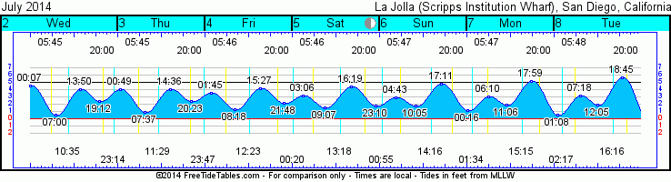
Tides for La Jolla (Scripps Institution Wharf) starting with July 2, 2014.
www.saltwatertides.com
Day High Tide Height Sunrise Moon Time % Moon
/Low Time Feet Sunset Visible
W 2 High 12:06 AM 4.6 5:45 AM Rise 10:36 AM 17
2 Low 7:00 AM 0.5 8:01 PM Set 11:15 PM
2 High 1:51 PM 4.0
2 Low 7:11 PM 2.5
Th 3 High 12:48 AM 4.1 5:45 AM Rise 11:29 AM 25
3 Low 7:36 AM 0.9 8:01 PM Set 11:47 PM
3 High 2:37 PM 4.0
3 Low 8:24 PM 2.5
F 4 High 1:43 AM 3.6 5:46 AM Rise 12:23 PM 34
4 Low 8:17 AM 1.2 8:01 PM
4 High 3:27 PM 4.2
4 Low 9:50 PM 2.2
Sa 5 High 3:05 AM 3.1 5:46 AM Set 12:20 AM 43
5 Low 9:05 AM 1.6 8:01 PM Rise 1:19 PM
5 High 4:19 PM 4.5
5 Low 11:12 PM 1.8
Su 6 High 4:44 AM 2.9 5:47 AM Set 12:56 AM 53
6 Low 10:03 AM 1.8 8:01 PM Rise 2:16 PM
6 High 5:10 PM 4.8
No comments:
Post a Comment