I’m heading out of town until next Wednesday so this will have to hold ya’ until Thursday night! Much cleaner conditions the past two days after some wind and rain. That new SW groundswell (i.e. inconsistent) is picking up and looks to give us some fun waist/chest waves for Friday. We’ve got some NW on top of that as well so most beaches around town should get some surfable activity. Saturday things back down a little with waist high waves mostly out of the south. Sunday a new shorter period NW looks to move into town with waves back up into the waist high range and then picking up with more WNW windswell Monday with waist/chest and some shoulder high sets at the standout beaches. Swell peaks late afternoon Monday with size fading quickly on Tuesday. Waist/chest to start the day Tuesday but fading off to waist with the occasional chest high set by sunset. Size drops off Wednesday morning with thigh/waist high but a new NW looks to fill in Thurs but really only giving us some waist high waves. Things look to get a little quiet after that.
Weather is looking mostly favorable as we head into the weekend. Cooler nighttime temps and air temps in the low 70s along the coast until Sunday when a low pressure system drops in and really cools things down. Look for low 60s for daytime temps Sunday and Monday with a slight chance of showers for Sunday night and Monday. Then right back into the low 70s daytime and low 50s nighttime with clear skies for the rest of the week. Winds are looking pretty favorable too with some light south winds developing as that system moves in. The middle of the week looks like light winter Santa Ana
Looks like pretty nice conditions with some fun surf over the next 5-6 days.
Stay wet San Diego
Mish

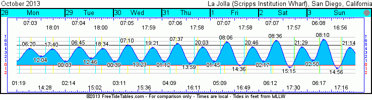
Tides for La Jolla (Scripps Institution Wharf
www.saltwatertides.com
Day High Tide Height Sunrise
/Low Time Feet Sunset Visible
F 1 Low 1:44 AM 1.0 7:07 AM Rise 5:10 AM 8
1 High 8:06 AM 5.8 5:58 PM Set 4:49 PM
1 Low 2:37 PM 0.0
1 High 8:46 PM 4.5
Sa 2 Low 2:16 AM 1.1 7:08 AM Rise 6:12 AM 3
2 High 8:36 AM 6.2 5:57 PM Set 5:30 PM
2 Low 3:15 PM -0.5
2 High 9:29 PM 4.5
Su 3 Low 2:50 AM 1.3 6:09 AM Rise 6:17 AM 0
3 High 8:09 AM 6.4 4:56 PM Set 5:16 PM
3 Low 2:57 PM -0.8
3 High 9:14 PM 4.4
M 4 Low 2:25 AM 1.5 6:10 AM Rise 7:22 AM 0
4 High 8:45 AM 6.5 4:55 PM Set 6:08 PM
4 Low 3:41 PM -0.9
4 High 10:03 PM 4.2
Tu 5 Low 3:03 AM 1.7 6:11 AM Rise 8:26 AM 2
5 High 9:25 AM 6.4 4:54 PM Set 7:05 PM
5 Low 4:29 PM -0.9
5 High 10:57 PM 4.0


.jpg)


