Aloha all! Hope everyone hopped in the nice clean
conditions this morning because that’s all about to change! We’re looking at a low pressure system moving
in with a lot of wind swell and wind in the next 48-72 hours. South winds are already blowing and will
continue as WNW wind swell fills in for Monday. We’ll see some waist high waves out of the SW
with sloppy wind swell on top of that.
Same thing for Tuesday with
more winds and plenty of WNW wind swell.
As things calm down on Wed we’ll
see some steep S swell from Hurricane Raymond who is spinning nicely SW of Cabo
and headed in our direction. The better
summer spots will see some waist/chest high surf out of that continuing and
joined by new SW groundswell Thursday. Surf in the waist/chest with some better
shoulder high sets around town. With
that added SW more spots will show this secondary S swell than the hurricane
swell but the added energy will help boost surf around town. Surf holds Friday with size tapering a tad on Saturday. A new NW swell
will start to fill in Sunday and
into Monday for more waves to kick
off the work week.
As for the weather
we’re looking at S/SE winds through the night picking up at dawn blowing pretty
hard throughout the day and thru Tuesday. Accompanying those winds will be some
showers…chance of showers Monday with more chance of showers after about 5pm
and thru the night. More showers on and
off Tuesday. Winds switch from S/SW to W
on Wednesday but calm down a little and we might even get some offshores by
Thurs/Fri. Air temps get a bit chilly
for us So Cal folks with low 60s during the day thru Wed and a bit more
sunshine and high 60s for Thursday.
Clear skies and warming for Friday.
Next weekend looks to be sunny and in the low 70s/high 60s and will be
carried on into next week. Water temps
have definitely cooled down with low 60s already in spots and probably cooler
temps on the way with all the wind and weather we’re about to have. We’ll see medium tides for Monday but tides
will start to swing a bit more extreme with a high in the AM and low in the
early afternoon as we move through the week towards the New Moon this weekend.
Oh boy…more
weather, more poopy water but then some reprieve!
Stay healthy but
wet San Diego!
Mish

Drive safely!
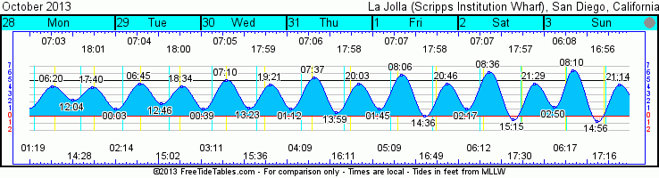
Tides for La Jolla (Scripps Institution Wharf) starting with October 28, 2013.
www.saltwatertides.com
Day High Tide Height Sunrise Moon Time % Moon
/Low Time Feet Sunset Visible
M 28 High 6:22 AM 4.2 7:04 AM Rise 1:20 AM 41
28 Low 12:03 PM 2.4 6:02 PM Set 2:29 PM
28 High 5:39 PM 4.0
Tu 29 Low 12:04 AM 1.1 7:05 AM Rise 2:15 AM 32
29 High 6:46 AM 4.6 6:01 PM Set 3:03 PM
29 Low 12:46 PM 1.7
29 High 6:34 PM 4.2
W 30 Low 12:39 AM 1.0 7:06 AM Rise 3:11 AM 23
30 High 7:11 AM 5.0 6:00 PM Set 3:37 PM
30 Low 1:23 PM 1.2
30 High 7:20 PM 4.3
Th 31 Low 1:12 AM 1.0 7:07 AM Rise 4:09 AM 15
31 High 7:37 AM 5.4 5:59 PM Set 4:12 PM
31 Low 2:00 PM 0.5
31 High 8:03 PM 4.5
F 1 Low 1:44 AM 1.0 7:07 AM Rise 5:10 AM 8
1 High 8:06 AM 5.8 5:58 PM Set 4:49 PM
1 Low 2:37 PM 0.0
1 High 8:46 PM 4.5
No comments:
Post a Comment