Ok, updating the
upcoming sizable swell it looks like we’ll be battling wind with this swell so
you need to catch the right wind windows to get the best conditions (I guess
that’s sort of always the case but…). We’re looking at an overnight N breeze
that will be probably putting some bump on the already HH waves from the latest
shorter period ground swell we’ve been seeing the last day or so. There’s still plenty of energy in the water
for Monday’s session. I’d try to catch it early as the winds will
pick up again with more HH and slightly OH straight W swell. Surf will pick up through the second half of
the day and overnight. The next swell peaks Tuesday mid-morning. Size
will be in the OH to OH+ range…8-10’ faces in SD, 6-8’ in LA/OC I’m thinking
with some slightly bigger sets at the best spots. Pretty much straight west so lined up and
some closeout at the west facing beach breaks. This swell is fairly short period too so plenty
of energy and plenty of waves all day.
The big trick will be the wind. See below for the wind conditions.
Wednesday things back off but we’ll still see
consistent OH+
range waves to kick off the day. The swell
quickly fades to about HH by nightfall. Thursday will see HH waves to start the day and the last of the
swell will fade quickly through the day to end with some waist/chest high waves
by sunset. Luckily another longer period
W groundswell is right there to kick things back into the chest/shoulder range
for Friday with some slightly OH
sets hitting by nightfall. Waves remain
in the HH range or just slightly smaller for Saturday and Sunday before tapering off into the start of the next
week. There’s a little lull but still
more swell generators out there in the N. Pac. We should have more fun surf on the way!
As I mentioned the
wind will be our biggest enemy or our best friend with this next swell. Monday looks to be a fairly windy day so I’d
hit it early as the tide pushes starting at dawn. Forecast is for some gusty NW winds by midday
which will make a bit of a mess of our nice swell. Luckily, it should subside
overnight and turn out of the E. This should really help clean things up for
the best part of the swell Tues AM.
Winds will turn back out of the W by the afternoon though so again, I’d
hit the AM session for the best conditions.
Wednesday the weather pattern starts to change up with slightly calmer
winds and patchy AM fog. The second half
of the week looks much more favorable with a bit of NE
Santa Ana kicking in. NE
winds from Wed thru Friday and air temps from the high 60s Mon/Tues to the high
70s/low80s for the second half of the week and into the weekend. Medium low tides at dawn pushing up through
the day for a medium high midday and then back down again for another medium
low a bit after sunset. Water temps
still at an amazing 60-63 degrees up and down the So Cal coastline.
Looks to be
another fun week of sizable surf! Have fun and stay wet So Cal!
Mish

Unknown
Grom ripping it at a secret N.county spot
Feb. 15, 2010
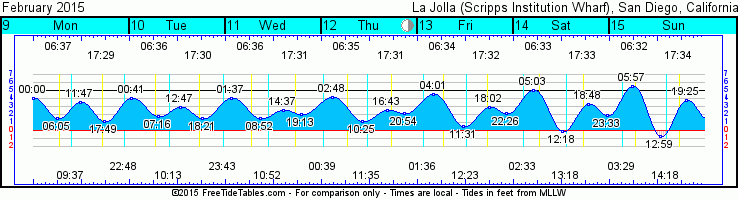
Tides for La Jolla (Scripps Institution Wharf) starting with February 9, 2015.
www.saltwatertides.com
Day High Tide Height Sunrise Moon Time % Moon
/Low Time Feet Sunset Visible
M 9 High 12:00 AM 4.1 6:38 AM Set 9:37 AM 80
9 Low 6:06 AM 1.6 5:29 PM Rise 10:48 PM
9 High 11:46 AM 3.4
9 Low 5:48 PM 1.2
Tu 10 High 12:41 AM 4.0 6:37 AM Set 10:12 AM 72
10 Low 7:17 AM 1.7 5:30 PM Rise 11:43 PM
10 High 12:48 PM 2.9
10 Low 6:20 PM 1.6
W 11 High 1:35 AM 4.1 6:36 AM Set 10:51 AM 63
11 Low 8:52 AM 1.6 5:31 PM
11 High 2:38 PM 2.5
11 Low 7:12 PM 2.0
Th 12 High 2:47 AM 4.2 6:35 AM Rise 12:40 AM 53
12 Low 10:25 AM 1.2 5:32 PM Set 11:35 AM
12 High 4:45 PM 2.6
12 Low 8:55 PM 2.2
F 13 High 4:01 AM 4.5 6:34 AM Rise 1:37 AM 43
13 Low 11:30 AM 0.5 5:32 PM Set 12:23 PM
13 High 6:02 PM 2.9
13 Low 10:27 PM 2.2
No comments:
Post a Comment